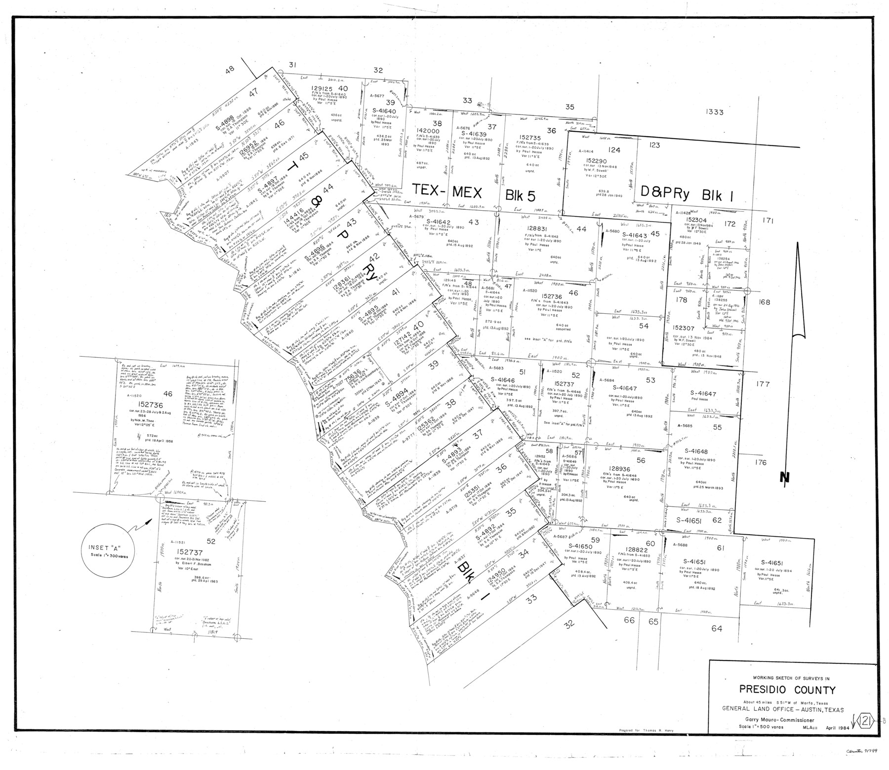
Presidio County Working Sketch 121b
-
Map/Doc
71799
-
Collection
General Map Collection
-
Object Dates
4/1984 (Creation Date)
-
Counties
Presidio
-
Subjects
Surveying Working Sketch
-
Height x Width
36.0 x 41.5 inches
91.4 x 105.4 cm
-
Scale
1" = 500 varas
Part of: General Map Collection

Real County Working Sketch 84

Print $20.00
- Digital $50.00
Real County Working Sketch 84
1986
Size 25.0 x 40.7 inches
Map/Doc 71976
Denton County Working Sketch 19

Print $20.00
- Digital $50.00
Denton County Working Sketch 19
1976
Size 24.3 x 27.3 inches
Map/Doc 68624
Map of Milam County

Print $20.00
- Digital $50.00
Map of Milam County
1868
Size 28.2 x 23.9 inches
Map/Doc 3882
Map of Cherokee Co.

Print $40.00
- Digital $50.00
Map of Cherokee Co.
1902
Size 49.6 x 39.7 inches
Map/Doc 4908
Sterling County Sketch File 19

Print $8.00
- Digital $50.00
Sterling County Sketch File 19
1949
Size 11.2 x 8.6 inches
Map/Doc 37169
Map of Williamson County

Print $20.00
- Digital $50.00
Map of Williamson County
1863
Size 22.7 x 29.7 inches
Map/Doc 4150
Jeff Davis County Working Sketch 47

Print $20.00
- Digital $50.00
Jeff Davis County Working Sketch 47
2000
Size 30.1 x 40.1 inches
Map/Doc 66542

Upton County Sketch File 8

Print $4.00
- Digital $50.00
Upton County Sketch File 8
1913
Size 14.4 x 8.8 inches
Map/Doc 38822
Bosque County Working Sketch 29

Print $20.00
- Digital $50.00
Bosque County Working Sketch 29
2009
Size 35.9 x 40.6 inches
Map/Doc 88997
Colorado County Working Sketch 29

Print $20.00
- Digital $50.00
Colorado County Working Sketch 29
1980
Size 15.4 x 12.4 inches
Map/Doc 68129
You may also like

![90591, [Block K7], Twichell Survey Records](https://historictexasmaps.com/wmedia_w700/maps/90591-1.tif.jpg)
Concho County Boundary File 3

Print $10.00
- Digital $50.00
Concho County Boundary File 3
Size 8.5 x 3.9 inches
Map/Doc 51820
Flight Mission No. DCL-6C, Frame 79, Kenedy County

Print $20.00
- Digital $50.00
Flight Mission No. DCL-6C, Frame 79, Kenedy County
1943
Size 18.6 x 22.4 inches
Map/Doc 85921
Brazos River, Clemens State Farm Sheet

Print $20.00
- Digital $50.00
Brazos River, Clemens State Farm Sheet
1915
Size 37.5 x 34.6 inches
Map/Doc 69673
Dallas County Working Sketch 15

Print $20.00
- Digital $50.00
Dallas County Working Sketch 15
1980
Size 14.3 x 11.4 inches
Map/Doc 68581
Potter County Sketch File 9

Print $20.00
- Digital $50.00
Potter County Sketch File 9
1887
Size 12.5 x 17.7 inches
Map/Doc 12198
[Blocks C34, C44, C40, C42, C31-C38, A19 and others in vicinity]
![93210, [Blocks C34, C44, C40, C42, C31-C38, A19 and others in vicinity], Twichell Survey Records](https://historictexasmaps.com/wmedia_w700/maps/93210-1.tif.jpg)
Print $40.00
- Digital $50.00
[Blocks C34, C44, C40, C42, C31-C38, A19 and others in vicinity]
Size 71.0 x 55.2 inches
Map/Doc 93210
Concho County Sketch File 6

Print $8.00
- Digital $50.00
Concho County Sketch File 6
1858
Size 13.3 x 8.3 inches
Map/Doc 19127
Deaf Smith County Sketch File 6

Print $12.00
- Digital $50.00
Deaf Smith County Sketch File 6
1912
Size 7.0 x 7.4 inches
Map/Doc 20658
Flight Mission No. DQN-6K, Frame 3, Calhoun County

Print $20.00
- Digital $50.00
Flight Mission No. DQN-6K, Frame 3, Calhoun County
1953
Size 18.3 x 22.1 inches
Map/Doc 84425
Hardin County Rolled Sketch 8

Print $20.00
- Digital $50.00
Hardin County Rolled Sketch 8
1947
Size 23.7 x 25.8 inches
Map/Doc 6081