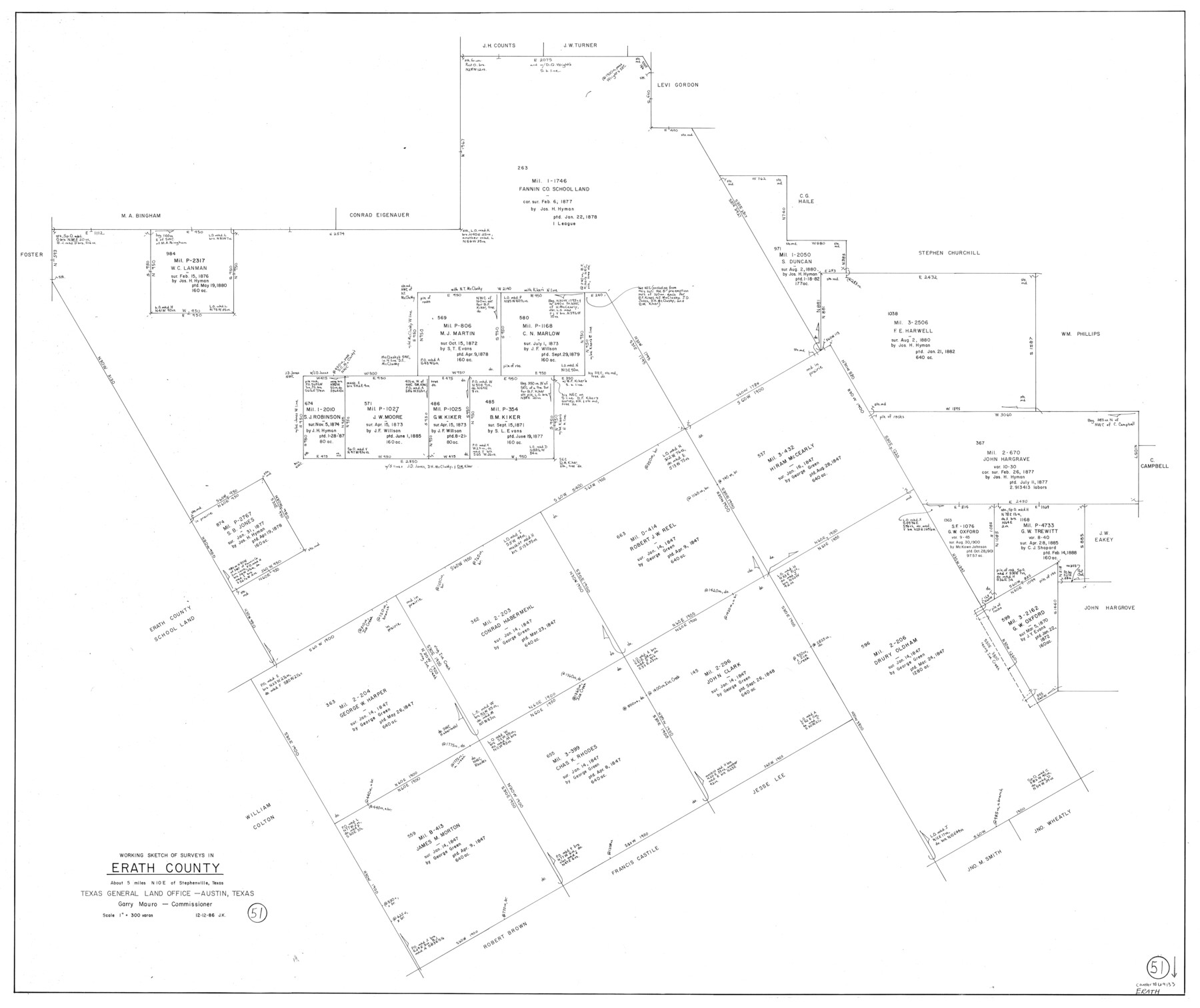
Erath County Working Sketch 51
-
Map/Doc
69133
-
Collection
General Map Collection
-
Object Dates
12/12/1986 (Creation Date)
-
People and Organizations
Joan Kilpatrick (Draftsman)
-
Counties
Erath
-
Subjects
Surveying Working Sketch
-
Height x Width
38.3 x 45.6 inches
97.3 x 115.8 cm
-
Scale
1" = 300 varas
Part of: General Map Collection
Flight Mission No. DCL-6C, Frame 50, Kenedy County

Print $20.00
- Digital $50.00
Flight Mission No. DCL-6C, Frame 50, Kenedy County
1943
Size 18.7 x 22.4 inches
Map/Doc 85892
Presidio County Rolled Sketch 129

Print $20.00
- Digital $50.00
Presidio County Rolled Sketch 129
1989
Size 27.0 x 46.0 inches
Map/Doc 7399
Flight Mission No. CGI-1N, Frame 182, Cameron County

Print $20.00
- Digital $50.00
Flight Mission No. CGI-1N, Frame 182, Cameron County
1955
Size 18.6 x 22.3 inches
Map/Doc 84517

Flight Mission No. CGI-3N, Frame 44, Cameron County

Print $20.00
- Digital $50.00
Flight Mission No. CGI-3N, Frame 44, Cameron County
1954
Size 18.9 x 22.5 inches
Map/Doc 84550
Galveston County Sketch File 34

Print $20.00
- Digital $50.00
Galveston County Sketch File 34
1934
Size 11.5 x 20.1 inches
Map/Doc 11536
Johnson County Sketch File 14a

Print $6.00
- Digital $50.00
Johnson County Sketch File 14a
1862
Size 8.0 x 11.1 inches
Map/Doc 28452
Mustang Island, Nueces County, Texas

Print $20.00
- Digital $50.00
Mustang Island, Nueces County, Texas
1978
Size 40.7 x 36.2 inches
Map/Doc 2500
Packery Channel

Print $20.00
- Digital $50.00
Packery Channel
1937
Size 23.8 x 22.4 inches
Map/Doc 3008
Duval County Working Sketch 44

Print $20.00
- Digital $50.00
Duval County Working Sketch 44
1977
Size 27.5 x 40.7 inches
Map/Doc 68768
Sketch of surveys made by Erath and Green in August 1846 on the waters of the Bosque River

Print $2.00
- Digital $50.00
Sketch of surveys made by Erath and Green in August 1846 on the waters of the Bosque River
1846
Size 10.6 x 7.8 inches
Map/Doc 303
Map of Zapata County

Print $20.00
- Digital $50.00
Map of Zapata County
1879
Size 27.4 x 25.6 inches
Map/Doc 4176
You may also like
Right of Way & Track Map Houston & Brazos Valley Ry. operated by Houston & Brazos Valley Ry. Co., Hoskins Mound Branch

Print $40.00
- Digital $50.00
Right of Way & Track Map Houston & Brazos Valley Ry. operated by Houston & Brazos Valley Ry. Co., Hoskins Mound Branch
1924
Size 25.3 x 56.4 inches
Map/Doc 64609
Jefferson County Rolled Sketch 50

Print $20.00
- Digital $50.00
Jefferson County Rolled Sketch 50
Size 34.2 x 41.6 inches
Map/Doc 9306
Webb County Sketch File 5

Print $8.00
- Digital $50.00
Webb County Sketch File 5
1876
Size 12.8 x 8.1 inches
Map/Doc 39725
Map of Robertson District

Print $40.00
- Digital $50.00
Map of Robertson District
1846
Size 81.3 x 45.3 inches
Map/Doc 3032
Burleson County Working Sketch 6

Print $20.00
- Digital $50.00
Burleson County Working Sketch 6
1980
Size 22.3 x 16.0 inches
Map/Doc 67725
T. & P. R. R. Co. Block 44, Township 1 S

Print $20.00
- Digital $50.00
T. & P. R. R. Co. Block 44, Township 1 S
Size 18.1 x 22.8 inches
Map/Doc 90826
Intracoastal Waterway, Houma, LA to Corpus Christi, TX

Print $20.00
- Digital $50.00
Intracoastal Waterway, Houma, LA to Corpus Christi, TX
Size 18.9 x 27.9 inches
Map/Doc 61906
A Geographically Correct County Map of States Traversed by the St. Louis, Iron Mountain & Southern Railway and its Connections

Print $20.00
- Digital $50.00
A Geographically Correct County Map of States Traversed by the St. Louis, Iron Mountain & Southern Railway and its Connections
1877
Size 18.5 x 16.1 inches
Map/Doc 95782
Upton County Working Sketch 26

Print $20.00
- Digital $50.00
Upton County Working Sketch 26
1953
Size 29.5 x 17.6 inches
Map/Doc 69522
Reeves County Sketch File 9

Print $20.00
- Digital $50.00
Reeves County Sketch File 9
Size 46.3 x 38.2 inches
Map/Doc 10587
Angelina County Working Sketch 3

Print $20.00
- Digital $50.00
Angelina County Working Sketch 3
1894
Size 17.9 x 16.6 inches
Map/Doc 67083
Township No. 5 South Range No. 15 West of the Indian Meridian

Print $4.00
- Digital $50.00
Township No. 5 South Range No. 15 West of the Indian Meridian
1875
Size 18.1 x 23.1 inches
Map/Doc 75138