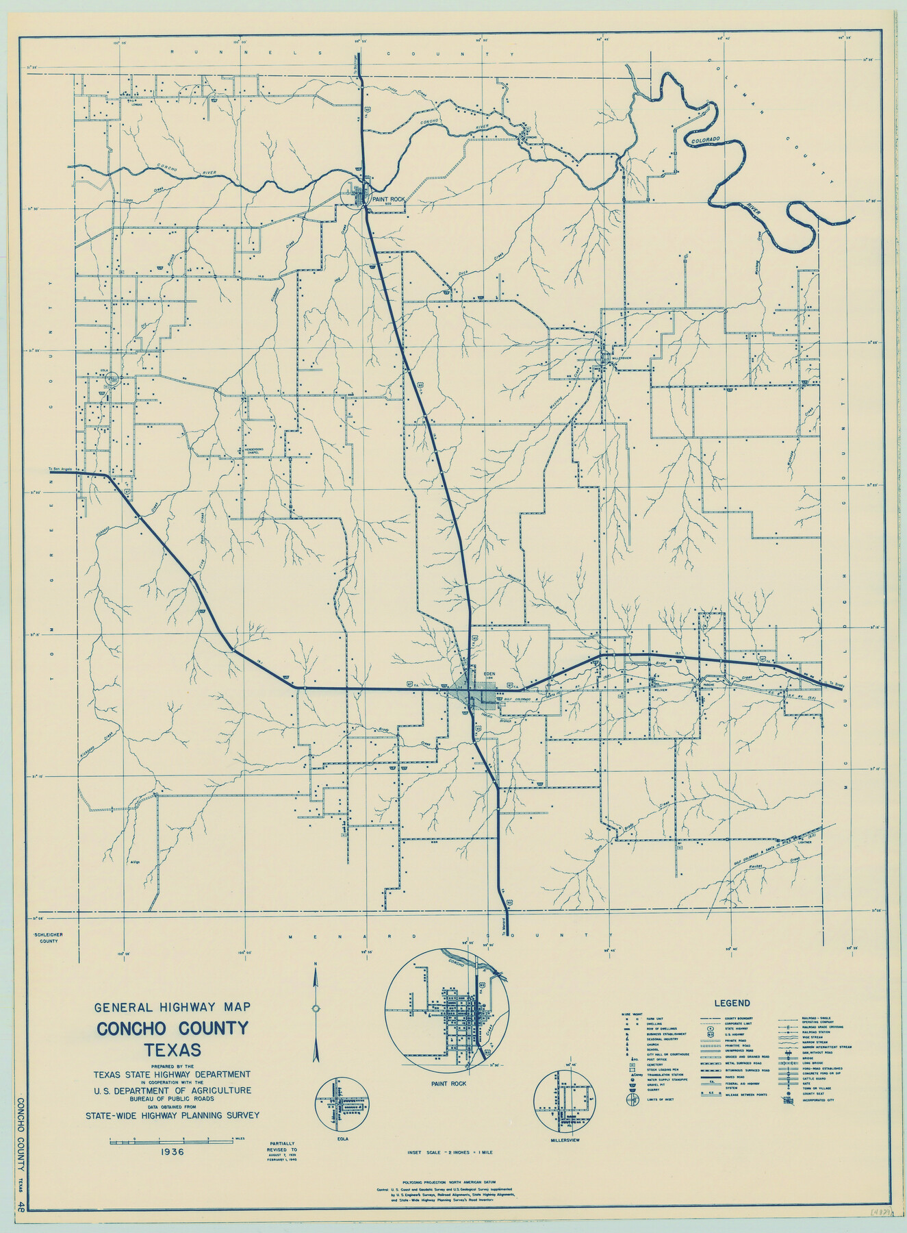
General Highway Map, Concho County, Texas
-
Map/Doc
79057
-
Collection
Texas State Library and Archives
-
Object Dates
1940 (Creation Date)
-
People and Organizations
Texas State Highway Department (Publisher)
-
Counties
Concho
-
Subjects
County
-
Height x Width
25.2 x 18.6 inches
64.0 x 47.2 cm
-
Comments
Prints available courtesy of the Texas State Library and Archives.
More info can be found here: TSLAC Map 04829
Part of: Texas State Library and Archives
General Highway Map, Frio County, Texas

Print $20.00
General Highway Map, Frio County, Texas
1940
Size 18.4 x 24.9 inches
Map/Doc 79095
Map of the Republic of Mexico

Print $20.00
Map of the Republic of Mexico
1882
Size 33.0 x 47.4 inches
Map/Doc 76220
Worley's Map of Greater Dallas

Print $20.00
Worley's Map of Greater Dallas
1905
Size 34.9 x 25.4 inches
Map/Doc 79319
General Highway Map, Jefferson County, Texas

Print $20.00
General Highway Map, Jefferson County, Texas
1940
Size 24.8 x 18.6 inches
Map/Doc 79144
General Highway Map, Johnson County, Texas

Print $20.00
General Highway Map, Johnson County, Texas
1961
Size 18.2 x 24.8 inches
Map/Doc 79545
Mapa de los Estados Unidos de Méjico, Segun lo organizado y definido por las varias actas del Congreso de dicha Republica: y construido por las mejores autoridades

Print $20.00
Mapa de los Estados Unidos de Méjico, Segun lo organizado y definido por las varias actas del Congreso de dicha Republica: y construido por las mejores autoridades
1846
Size 30.8 x 42.4 inches
Map/Doc 79727
General Highway Map, Orange County, Texas

Print $20.00
General Highway Map, Orange County, Texas
1940
Size 18.3 x 24.5 inches
Map/Doc 79212
General Highway Map, McCulloch County, Texas

Print $20.00
General Highway Map, McCulloch County, Texas
1961
Size 25.0 x 19.3 inches
Map/Doc 79588
General Highway Map, Kenedy County, Texas

Print $20.00
General Highway Map, Kenedy County, Texas
1961
Size 18.0 x 24.6 inches
Map/Doc 79446
General Highway Map, Madison County, Texas

Print $20.00
General Highway Map, Madison County, Texas
1940
Size 18.3 x 24.5 inches
Map/Doc 79183
General Highway Map, Presidio County, Texas

Print $20.00
General Highway Map, Presidio County, Texas
1940
Size 24.6 x 18.3 inches
Map/Doc 79222

You may also like
Hill County Sketch File 18

Print $26.00
- Digital $50.00
Hill County Sketch File 18
1852
Size 8.6 x 4.9 inches
Map/Doc 26486
Culberson County Rolled Sketch 42

Print $20.00
- Digital $50.00
Culberson County Rolled Sketch 42
Size 23.0 x 29.0 inches
Map/Doc 5663
Flight Mission No. BQR-9K, Frame 10, Brazoria County

Print $20.00
- Digital $50.00
Flight Mission No. BQR-9K, Frame 10, Brazoria County
1952
Size 18.7 x 22.3 inches
Map/Doc 84039
El Paso County Working Sketch 49

Print $20.00
- Digital $50.00
El Paso County Working Sketch 49
1990
Size 36.8 x 23.1 inches
Map/Doc 69071
McLennan County Sketch File 25

Print $2.00
- Digital $50.00
McLennan County Sketch File 25
Size 8.8 x 12.3 inches
Map/Doc 31299
Nolan County Sketch File 14

Print $20.00
- Digital $50.00
Nolan County Sketch File 14
1927
Size 32.6 x 20.0 inches
Map/Doc 42164
Edwards County Working Sketch 97

Print $20.00
- Digital $50.00
Edwards County Working Sketch 97
1969
Size 25.5 x 27.6 inches
Map/Doc 68973
Howard County Working Sketch 5

Print $20.00
- Digital $50.00
Howard County Working Sketch 5
1944
Size 23.9 x 32.8 inches
Map/Doc 66271
[Surveying sketch of Jones County showing Micaela Fiagoso survey]
![387, [Surveying sketch of Jones County showing Micaela Fiagoso survey], Maddox Collection](https://historictexasmaps.com/wmedia_w700/maps/0387-1.tif.jpg)
Print $20.00
- Digital $50.00
[Surveying sketch of Jones County showing Micaela Fiagoso survey]
Size 19.5 x 16.8 inches
Map/Doc 387
Hill County Sketch File 8

Print $4.00
- Digital $50.00
Hill County Sketch File 8
1859
Size 10.1 x 8.2 inches
Map/Doc 26472
Nueces County Sketch File 49

Print $20.00
- Digital $50.00
Nueces County Sketch File 49
1956
Size 32.4 x 17.1 inches
Map/Doc 42193
Culberson County Rolled Sketch 45

Print $20.00
- Digital $50.00
Culberson County Rolled Sketch 45
1954
Size 19.1 x 23.4 inches
Map/Doc 5667