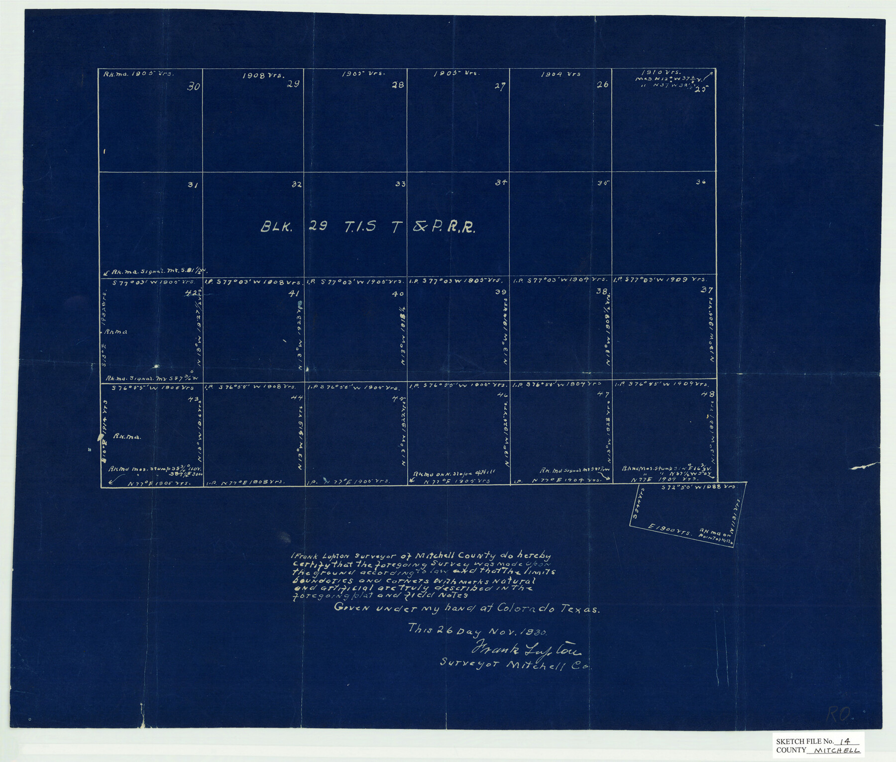
Mitchell County Sketch File 14
[T&PRRCo. Block 29, Tsp. 1 S, Mitchell County, Texas]
-
Map/Doc
12101
-
Collection
General Map Collection
-
Object Dates
11/26/1930 (Creation Date)
12/12/1930 (File Date)
-
People and Organizations
Frank L. Upton (Surveyor/Engineer)
-
Counties
Mitchell
-
Subjects
Surveying Sketch File
-
Height x Width
17.5 x 20.5 inches
44.5 x 52.1 cm
-
Medium
blueprint/diazo
Part of: General Map Collection
Edwards County Working Sketch 24

Print $20.00
- Digital $50.00
Edwards County Working Sketch 24
1942
Size 19.1 x 34.1 inches
Map/Doc 68900
Palo Pinto County Sketch File 6a

Print $20.00
- Digital $50.00
Palo Pinto County Sketch File 6a
Size 37.8 x 38.6 inches
Map/Doc 10565
Webb County Sketch File 14

Print $7.00
- Digital $50.00
Webb County Sketch File 14
1877
Size 10.0 x 8.2 inches
Map/Doc 39807
Comal County Sketch File 12

Print $4.00
- Digital $50.00
Comal County Sketch File 12
Size 8.4 x 11.3 inches
Map/Doc 19024
Jones County Boundary File 1

Print $78.00
- Digital $50.00
Jones County Boundary File 1
1882
Size 10.7 x 8.2 inches
Map/Doc 55633
Schleicher County

Print $40.00
- Digital $50.00
Schleicher County
1940
Size 38.7 x 54.9 inches
Map/Doc 73285
Flight Mission No. DQN-2K, Frame 78, Calhoun County

Print $20.00
- Digital $50.00
Flight Mission No. DQN-2K, Frame 78, Calhoun County
1953
Size 18.6 x 22.3 inches
Map/Doc 84270
Caldwell County Sketch File 5

Print $8.00
- Digital $50.00
Caldwell County Sketch File 5
Size 14.1 x 8.6 inches
Map/Doc 35843
Flight Mission No. CUG-1P, Frame 163, Kleberg County

Print $20.00
- Digital $50.00
Flight Mission No. CUG-1P, Frame 163, Kleberg County
1956
Size 18.6 x 22.2 inches
Map/Doc 86170
Wharton County Working Sketch 12

Print $20.00
- Digital $50.00
Wharton County Working Sketch 12
1970
Size 22.3 x 30.3 inches
Map/Doc 72476
Jackson County Sketch File 17

Print $20.00
- Digital $50.00
Jackson County Sketch File 17
1913
Size 19.4 x 19.1 inches
Map/Doc 11841
Atascosa County Working Sketch 25

Print $20.00
- Digital $50.00
Atascosa County Working Sketch 25
1958
Size 38.2 x 44.0 inches
Map/Doc 67221
You may also like
Map of the reconnaissance in Texas by Lieuts Blake & Meade of the Corps of Topl. Engs.

Print $20.00
- Digital $50.00
Map of the reconnaissance in Texas by Lieuts Blake & Meade of the Corps of Topl. Engs.
1846
Size 27.1 x 22.5 inches
Map/Doc 2003
Bastrop County Boundary File 2

Print $12.00
- Digital $50.00
Bastrop County Boundary File 2
Size 9.1 x 6.9 inches
Map/Doc 50315
Crosby County Boundary File 2

Print $64.00
- Digital $50.00
Crosby County Boundary File 2
Size 42.8 x 7.0 inches
Map/Doc 51997
Hunt County Sketch File 21

Print $4.00
- Digital $50.00
Hunt County Sketch File 21
Size 8.1 x 5.8 inches
Map/Doc 27122
Bell County Sketch File 15

Print $4.00
- Digital $50.00
Bell County Sketch File 15
1861
Size 6.4 x 8.0 inches
Map/Doc 14394
Map Showing Resurvey of Capitol Leagues, Lamb, Cochran & Hockley Co's.

Print $20.00
- Digital $50.00
Map Showing Resurvey of Capitol Leagues, Lamb, Cochran & Hockley Co's.
1918
Size 37.0 x 29.3 inches
Map/Doc 1759
Haskell County Working Sketch 16

Print $20.00
- Digital $50.00
Haskell County Working Sketch 16
1986
Size 37.9 x 47.3 inches
Map/Doc 66074
Orange County Working Sketch 3

Print $20.00
- Digital $50.00
Orange County Working Sketch 3
1917
Size 12.7 x 20.3 inches
Map/Doc 71335
Map of Shackelford County

Print $20.00
- Digital $50.00
Map of Shackelford County
1901
Size 26.5 x 21.9 inches
Map/Doc 63031
[H. & G. N. Block 28]
![90344, [H. & G. N. Block 28], Twichell Survey Records](https://historictexasmaps.com/wmedia_w700/maps/90344-1.tif.jpg)
Print $20.00
- Digital $50.00
[H. & G. N. Block 28]
Size 25.1 x 31.2 inches
Map/Doc 90344
[Bastrop District]
![83518, [Bastrop District], General Map Collection](https://historictexasmaps.com/wmedia_w700/maps/83518-1.tif.jpg)
Print $20.00
- Digital $50.00
[Bastrop District]
1838
Size 19.5 x 44.2 inches
Map/Doc 83518
Montague County Working Sketch 46

Print $20.00
- Digital $50.00
Montague County Working Sketch 46
2014
Size 14.7 x 20.4 inches
Map/Doc 93689