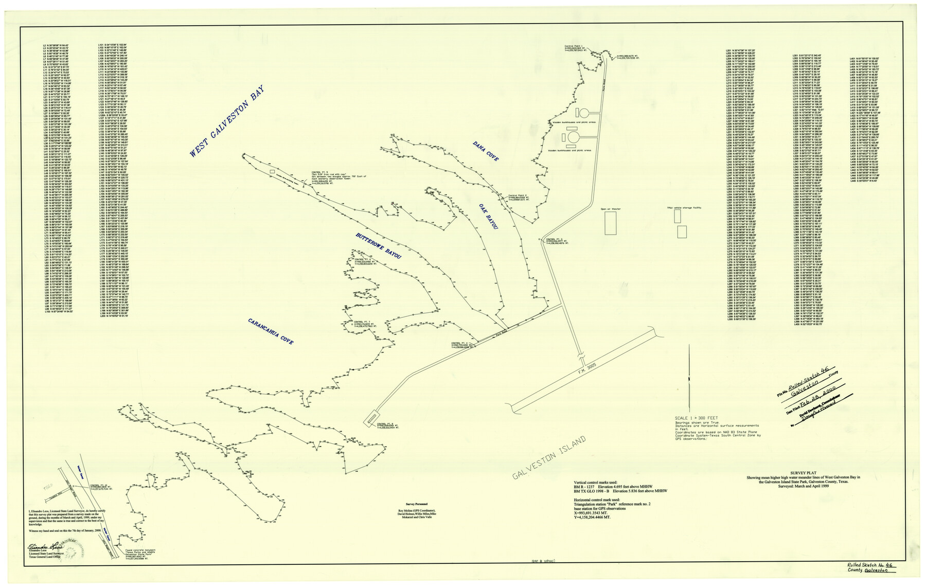
Galveston County Rolled Sketch 46
Survey plat showing mean higher high water meander lines of West Galveston Bay in the Galveston Island State Park
-
Map/Doc
5981
-
Collection
General Map Collection
-
Object Dates
1/7/2000 (Creation Date)
2/28/2000 (File Date)
4/1999 (Survey Date)
-
People and Organizations
Elisandro Leos (Surveyor/Engineer)
David Holmes (Chainman/Field Personnel)
Willie Miles (Chainman/Field Personnel)
Mike Mokarzel (Chainman/Field Personnel)
Chris Valle (Chainman/Field Personnel)
Rosendo V. Molina (Chainman/Field Personnel)
-
Counties
Galveston
-
Subjects
Surveying Rolled Sketch
-
Height x Width
32.0 x 48.3 inches
81.3 x 122.7 cm
-
Medium
mylar, print
-
Scale
1" = 300 feet
Part of: General Map Collection
Baylor County Sketch File 10

Print $40.00
- Digital $50.00
Baylor County Sketch File 10
1890
Size 19.3 x 42.7 inches
Map/Doc 10321
Dallas, Texas

Print $20.00
- Digital $50.00
Dallas, Texas
1890
Size 14.8 x 11.7 inches
Map/Doc 94085
Flight Mission No. DIX-8P, Frame 92, Aransas County

Print $20.00
- Digital $50.00
Flight Mission No. DIX-8P, Frame 92, Aransas County
1956
Size 18.5 x 22.3 inches
Map/Doc 83917
Flight Mission No. DCL-6C, Frame 5, Kenedy County

Print $20.00
- Digital $50.00
Flight Mission No. DCL-6C, Frame 5, Kenedy County
1943
Size 18.4 x 22.4 inches
Map/Doc 85865
Crockett County Working Sketch 64

Print $20.00
- Digital $50.00
Crockett County Working Sketch 64
1957
Size 19.0 x 25.4 inches
Map/Doc 68397
Flight Mission No. CGI-4N, Frame 174, Cameron County

Print $20.00
- Digital $50.00
Flight Mission No. CGI-4N, Frame 174, Cameron County
1955
Size 18.7 x 22.3 inches
Map/Doc 84677
Brewster County Working Sketch 24

Print $20.00
- Digital $50.00
Brewster County Working Sketch 24
1939
Size 17.2 x 42.1 inches
Map/Doc 67558
Port Facilities at Texas City, Tex.

Print $20.00
- Digital $50.00
Port Facilities at Texas City, Tex.
Size 13.9 x 15.9 inches
Map/Doc 97161
Crockett County Rolled Sketch 88M

Print $20.00
- Digital $50.00
Crockett County Rolled Sketch 88M
1964
Size 25.2 x 34.2 inches
Map/Doc 5629
Carta Agricola

Print $20.00
- Digital $50.00
Carta Agricola
1897
Size 26.0 x 34.3 inches
Map/Doc 96804
Fort Bend County Working Sketch 30

Print $20.00
- Digital $50.00
Fort Bend County Working Sketch 30
1983
Size 13.6 x 13.6 inches
Map/Doc 69236
Val Verde County Working Sketch 73

Print $20.00
- Digital $50.00
Val Verde County Working Sketch 73
1970
Size 37.6 x 34.5 inches
Map/Doc 72208
You may also like
General Highway Map, Reagan County, Texas

Print $20.00
General Highway Map, Reagan County, Texas
1940
Size 25.0 x 18.2 inches
Map/Doc 79225
Fannin County Boundary File 10a and 10b and 10c

Print $2.00
- Digital $50.00
Fannin County Boundary File 10a and 10b and 10c
Size 11.2 x 9.1 inches
Map/Doc 53327
Tyler County Sketch File 1

Print $22.00
- Digital $50.00
Tyler County Sketch File 1
1849
Size 12.2 x 15.3 inches
Map/Doc 38607
Brewster County Rolled Sketch 66

Print $20.00
- Digital $50.00
Brewster County Rolled Sketch 66
1940
Size 33.0 x 36.2 inches
Map/Doc 8490
Swisher County Sketch File 2b

Print $4.00
- Digital $50.00
Swisher County Sketch File 2b
1910
Size 11.2 x 8.7 inches
Map/Doc 37616
Gaines County

Print $40.00
- Digital $50.00
Gaines County
1956
Size 45.1 x 56.6 inches
Map/Doc 95504
Wilbarger County Working Sketch 8

Print $20.00
- Digital $50.00
Wilbarger County Working Sketch 8
1948
Size 31.8 x 38.2 inches
Map/Doc 72546
Hill County Sketch file 28

Print $33.00
- Digital $50.00
Hill County Sketch file 28
1987
Size 11.3 x 8.9 inches
Map/Doc 26530
Shackelford County Working Sketch 2

Print $20.00
- Digital $50.00
Shackelford County Working Sketch 2
1914
Size 17.2 x 17.3 inches
Map/Doc 63842
Lee County Sketch File 10

Print $10.00
- Digital $50.00
Lee County Sketch File 10
2009
Size 11.0 x 8.5 inches
Map/Doc 89289
Garden City, Tom Green County, Texas, Section 5, Range 4-S Block 33

Print $3.00
- Digital $50.00
Garden City, Tom Green County, Texas, Section 5, Range 4-S Block 33
1886
Size 10.0 x 16.6 inches
Map/Doc 92130
Hunt County Sketch File 20

Print $4.00
- Digital $50.00
Hunt County Sketch File 20
1853
Size 8.3 x 7.9 inches
Map/Doc 27120