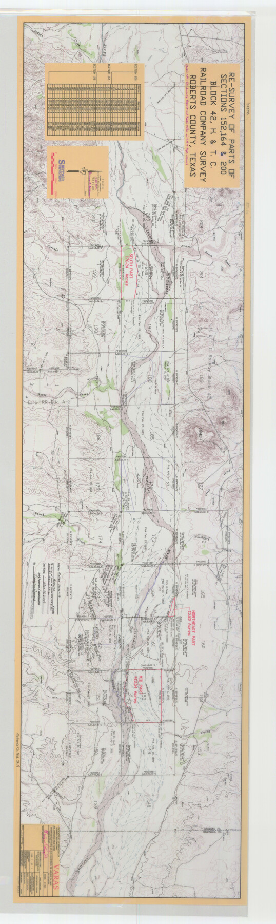
Roberts County Rolled Sketch 4
Re-survey of parts of sections 152, 164, & 200, Block 42, H. & T. C. Railroad Company survey, Roberts County, Texas [and report]
-
Map/Doc
83620
-
Collection
General Map Collection
-
Object Dates
2006/1/23 (Creation Date)
2006/3/16 (File Date)
-
People and Organizations
Maxey Sheppard (Surveyor/Engineer)
-
Counties
Roberts
-
Subjects
Surveying Rolled Sketch
-
Height x Width
66.9 x 20.0 inches
169.9 x 50.8 cm
-
Medium
mylar, print
-
Scale
1" = 500 varas
Part of: General Map Collection
Travis County Rolled Sketch 40

Print $407.00
- Digital $50.00
Travis County Rolled Sketch 40
1953
Size 10.4 x 15.4 inches
Map/Doc 49195
[Surveys along Eight Mile Creek, Harrison District]
![278, [Surveys along Eight Mile Creek, Harrison District], General Map Collection](https://historictexasmaps.com/wmedia_w700/maps/278.tif.jpg)
Print $3.00
- Digital $50.00
[Surveys along Eight Mile Creek, Harrison District]
Size 12.6 x 9.3 inches
Map/Doc 278
Dimmit County Rolled Sketch 15

Print $20.00
- Digital $50.00
Dimmit County Rolled Sketch 15
1925
Size 32.8 x 23.4 inches
Map/Doc 5723
Knox County Rolled Sketch 14

Print $40.00
- Digital $50.00
Knox County Rolled Sketch 14
1892
Size 21.8 x 54.9 inches
Map/Doc 10666
[Tom Green County]
![82060, [Tom Green County], General Map Collection](https://historictexasmaps.com/wmedia_w700/maps/82060.tif.jpg)
Print $40.00
- Digital $50.00
[Tom Green County]
1888
Size 45.8 x 113.0 inches
Map/Doc 82060
Chart of the West Indies and Spanish Dominions in North America

Print $20.00
- Digital $50.00
Chart of the West Indies and Spanish Dominions in North America
1803
Size 25.5 x 38.9 inches
Map/Doc 97139
Clay County Sketch File 5

Print $5.00
- Digital $50.00
Clay County Sketch File 5
1859
Size 8.6 x 3.8 inches
Map/Doc 18393
Calhoun County Rolled Sketch 30

Print $20.00
- Digital $50.00
Calhoun County Rolled Sketch 30
1974
Size 18.5 x 27.5 inches
Map/Doc 5496
Gregg County Working Sketch 19

Print $20.00
- Digital $50.00
Gregg County Working Sketch 19
1957
Size 31.7 x 37.3 inches
Map/Doc 63286
Hemphill County Working Sketch 7

Print $20.00
- Digital $50.00
Hemphill County Working Sketch 7
1964
Size 41.1 x 46.8 inches
Map/Doc 66102
Hutchinson County Sketch File 50

Print $12.00
- Digital $50.00
Hutchinson County Sketch File 50
1992
Size 14.2 x 8.8 inches
Map/Doc 27434
Camp County Working Sketch 2

Print $20.00
- Digital $50.00
Camp County Working Sketch 2
1975
Size 24.8 x 24.5 inches
Map/Doc 67878
You may also like
Terry County Sketch File 14

Print $20.00
- Digital $50.00
Terry County Sketch File 14
Size 11.1 x 42.4 inches
Map/Doc 10398
Marion County Working Sketch 40

Print $20.00
- Digital $50.00
Marion County Working Sketch 40
1992
Size 42.9 x 30.0 inches
Map/Doc 70816
Llano County Working Sketch 7

Print $20.00
- Digital $50.00
Llano County Working Sketch 7
1968
Size 30.9 x 30.3 inches
Map/Doc 70625
Flight Mission No. DAH-17M, Frame 62, Orange County

Print $20.00
- Digital $50.00
Flight Mission No. DAH-17M, Frame 62, Orange County
1953
Size 18.5 x 22.6 inches
Map/Doc 86896
Uvalde County Working Sketch 65

Print $20.00
- Digital $50.00
Uvalde County Working Sketch 65
Size 34.8 x 43.0 inches
Map/Doc 69696
Armstrong County Sketch File A-15

Print $40.00
- Digital $50.00
Armstrong County Sketch File A-15
Size 17.8 x 14.0 inches
Map/Doc 13716

Chambers County NRC Article 33.136 Sketch 2

Print $2.00
- Digital $50.00
Chambers County NRC Article 33.136 Sketch 2
2004
Size 8.2 x 10.8 inches
Map/Doc 82998
State Highway System of Texas Showing Condition of Improvement

Print $5.00
- Digital $50.00
State Highway System of Texas Showing Condition of Improvement
1929
Size 28.5 x 30.9 inches
Map/Doc 93720
Andrews County Sketch File 14

Print $48.00
- Digital $50.00
Andrews County Sketch File 14
1887
Size 8.0 x 8.4 inches
Map/Doc 12872
San Saba County Sketch File 5

Print $4.00
- Digital $50.00
San Saba County Sketch File 5
Size 12.8 x 8.0 inches
Map/Doc 36412
[North part of G. C. & S. F. Block OP, Runnels County School Land]
![90309, [North part of G. C. & S. F. Block OP, Runnels County School Land], Twichell Survey Records](https://historictexasmaps.com/wmedia_w700/maps/90309-1.tif.jpg)
Print $20.00
- Digital $50.00
[North part of G. C. & S. F. Block OP, Runnels County School Land]
Size 14.3 x 17.6 inches
Map/Doc 90309