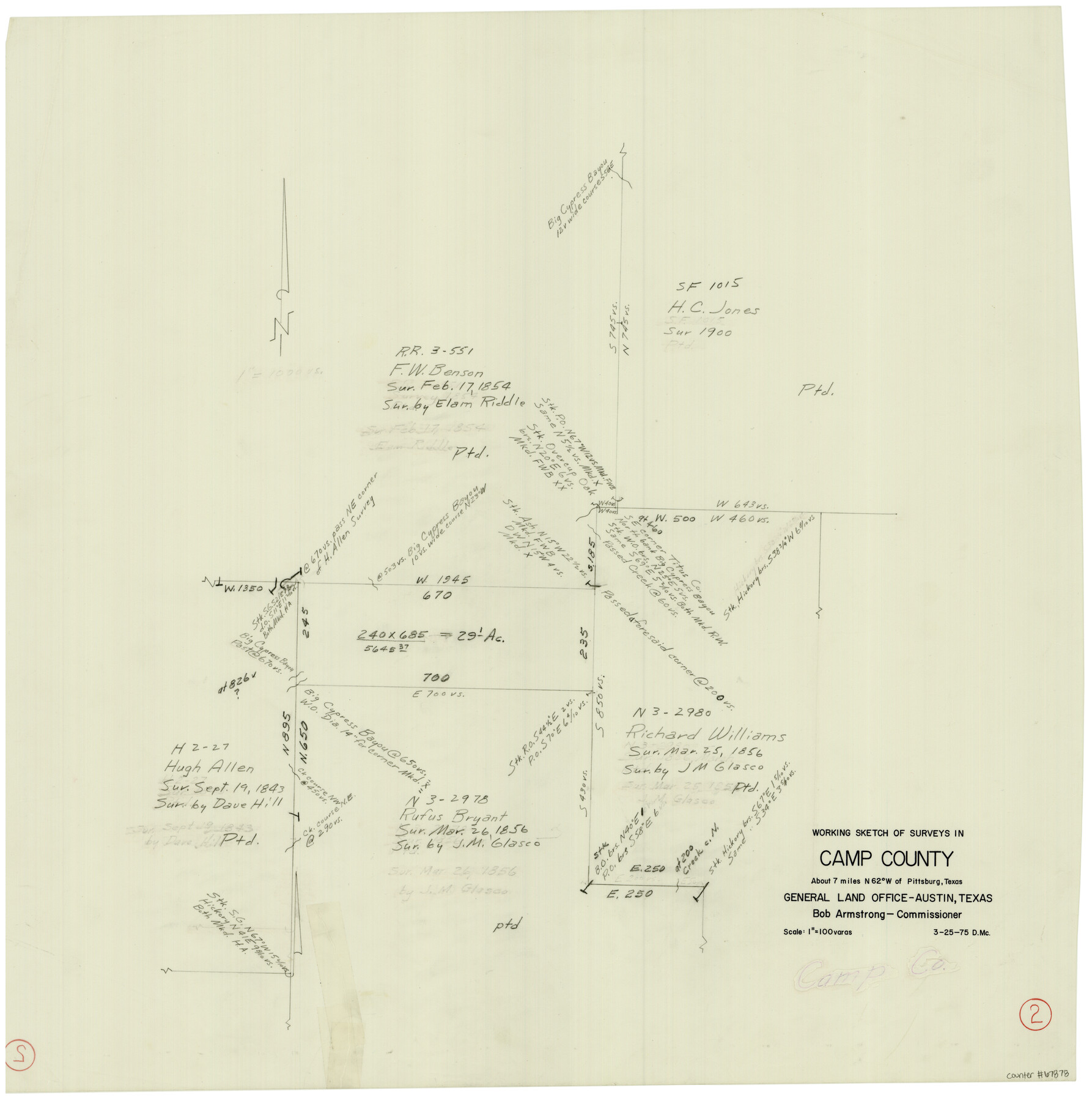
Camp County Working Sketch 2
-
Map/Doc
67878
-
Collection
General Map Collection
-
Object Dates
3/25/1975 (Creation Date)
-
Counties
Camp
-
Subjects
Surveying Working Sketch
-
Height x Width
24.8 x 24.5 inches
63.0 x 62.2 cm
-
Scale
1" = 100 varas
Part of: General Map Collection
Dallas, Ft. Worth, & Vicinity, Texas - Regional Map

Dallas, Ft. Worth, & Vicinity, Texas - Regional Map
1997
Size 25.7 x 36.7 inches
Map/Doc 97289
Flight Mission No. BRA-7M, Frame 181, Jefferson County

Print $20.00
- Digital $50.00
Flight Mission No. BRA-7M, Frame 181, Jefferson County
1953
Size 18.6 x 22.4 inches
Map/Doc 85549
Brazoria County NRC Article 33.136 Sketch 9

Print $24.00
- Digital $50.00
Brazoria County NRC Article 33.136 Sketch 9
2007
Size 24.2 x 34.1 inches
Map/Doc 87929
Jack County Working Sketch 24

Print $20.00
- Digital $50.00
Jack County Working Sketch 24
2010
Size 24.1 x 29.7 inches
Map/Doc 90030
Fort Bend Co.

Print $20.00
- Digital $50.00
Fort Bend Co.
1931
Size 40.5 x 41.3 inches
Map/Doc 77282
Flight Mission No. BRE-1P, Frame 114, Nueces County

Print $20.00
- Digital $50.00
Flight Mission No. BRE-1P, Frame 114, Nueces County
1956
Size 18.6 x 22.9 inches
Map/Doc 86680
Geodetic positions of authentic boundary mounds, established by Louisiana Geodetic Survey traverse

Print $4.00
- Digital $50.00
Geodetic positions of authentic boundary mounds, established by Louisiana Geodetic Survey traverse
Size 28.8 x 28.7 inches
Map/Doc 1734
Flight Mission No. BRA-6M, Frame 81, Jefferson County

Print $20.00
- Digital $50.00
Flight Mission No. BRA-6M, Frame 81, Jefferson County
1953
Size 18.6 x 22.6 inches
Map/Doc 85425
King County Sketch File 6 (1)

Print $43.00
- Digital $50.00
King County Sketch File 6 (1)
1897
Size 14.5 x 15.7 inches
Map/Doc 29027
[Surveys along the Colorado River]
![112, [Surveys along the Colorado River], General Map Collection](https://historictexasmaps.com/wmedia_w700/maps/112.tif.jpg)
Print $2.00
- Digital $50.00
[Surveys along the Colorado River]
1841
Size 12.2 x 8.3 inches
Map/Doc 112
Caddo Lake and Subdivision

Print $20.00
- Digital $50.00
Caddo Lake and Subdivision
1918
Size 35.0 x 29.8 inches
Map/Doc 93283
Travis County Boundary File 4

Print $52.00
- Digital $50.00
Travis County Boundary File 4
Size 9.5 x 8.2 inches
Map/Doc 59420
You may also like

Eastland County Working Sketch 23

Print $40.00
- Digital $50.00
Eastland County Working Sketch 23
1920
Size 53.5 x 42.5 inches
Map/Doc 68804

Tyler County Sketch File 1a

Print $4.00
- Digital $50.00
Tyler County Sketch File 1a
1855
Size 8.2 x 10.3 inches
Map/Doc 38609
Morton, Cochran County, Texas / Morton Cemetery First Addition, Cochran County, Texas

Print $20.00
- Digital $50.00
Morton, Cochran County, Texas / Morton Cemetery First Addition, Cochran County, Texas
Size 30.8 x 34.6 inches
Map/Doc 92542
Map of Texas, compiled from surveys on record in the General Land Office of the Republic

Print $20.00
Map of Texas, compiled from surveys on record in the General Land Office of the Republic
1847
Size 32.2 x 25.0 inches
Map/Doc 79325
Tyler County Working Sketch 8

Print $20.00
- Digital $50.00
Tyler County Working Sketch 8
1937
Size 31.0 x 34.9 inches
Map/Doc 69478
Harris County Boundary File 40

Print $8.00
- Digital $50.00
Harris County Boundary File 40
Size 14.2 x 8.7 inches
Map/Doc 54370
Upton County Sketch File 2

Print $40.00
- Digital $50.00
Upton County Sketch File 2
Size 38.5 x 55.4 inches
Map/Doc 10413
Map of Nacogdoches County

Print $20.00
- Digital $50.00
Map of Nacogdoches County
1881
Size 24.1 x 21.5 inches
Map/Doc 3909
Outer Continental Shelf Leasing Maps (Louisiana Offshore Operations)

Print $20.00
- Digital $50.00
Outer Continental Shelf Leasing Maps (Louisiana Offshore Operations)
1955
Size 14.0 x 12.8 inches
Map/Doc 76085
Flight Mission No. BRA-9M, Frame 72, Jefferson County

Print $20.00
- Digital $50.00
Flight Mission No. BRA-9M, Frame 72, Jefferson County
1953
Size 18.5 x 22.6 inches
Map/Doc 85655