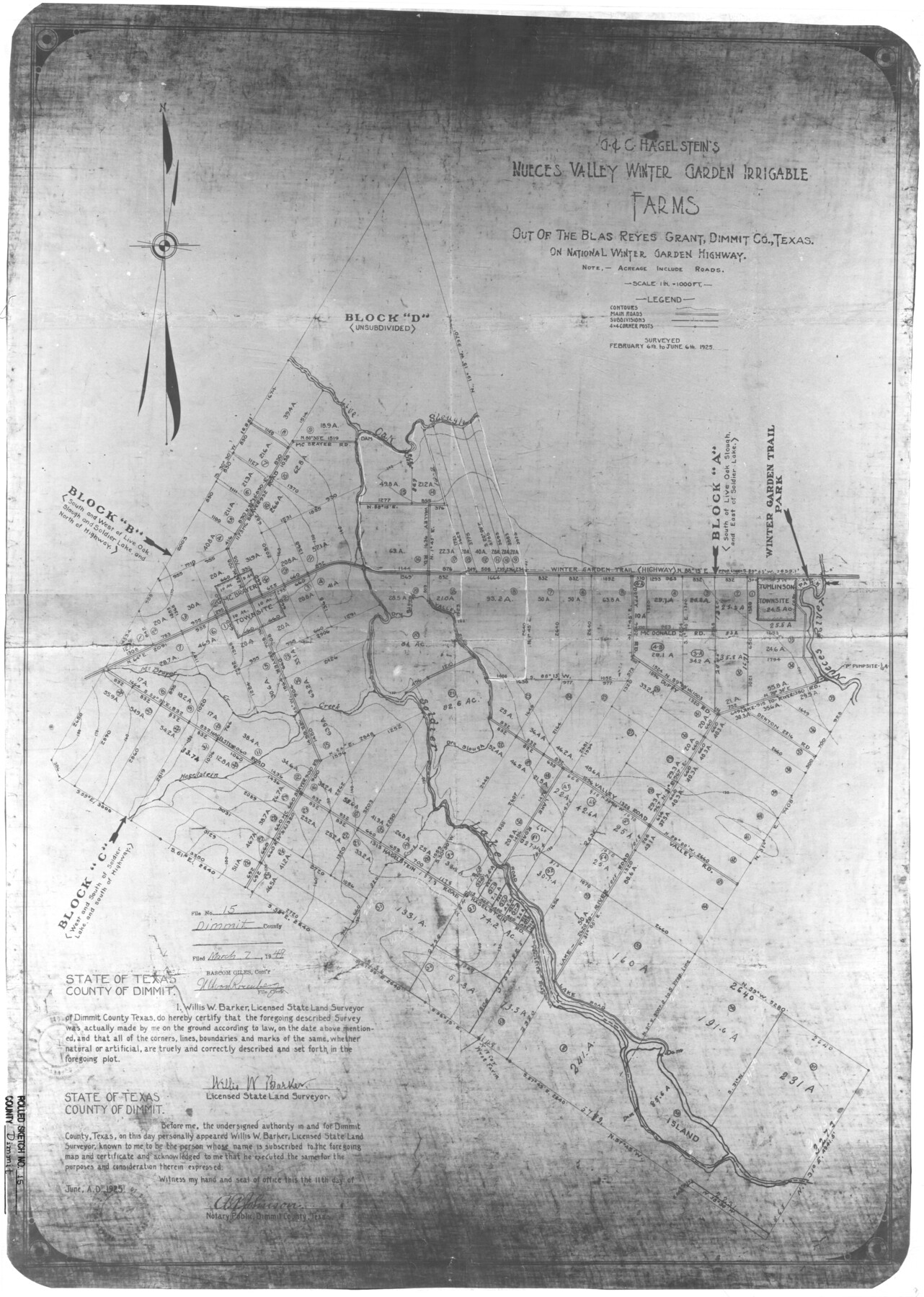
Dimmit County Rolled Sketch 15
G. & C. Hagelstein's Nueces Valley Winter Garden Irrigable Farms out of the Blas Reyes grant, Dimmit Co., Texas on National Winter Garden Highway
-
Map/Doc
5723
-
Collection
General Map Collection
-
Object Dates
1925/6/6 (Creation Date)
1949/3/7 (File Date)
-
People and Organizations
Willis W. Barker (Surveyor/Engineer)
-
Counties
Dimmit
-
Subjects
Cadastral Surveying Rolled Sketch
-
Height x Width
32.8 x 23.4 inches
83.3 x 59.4 cm
-
Medium
photostat
-
Scale
1" = 1000 feet
Part of: General Map Collection
Flight Mission No. DQN-3K, Frame 10, Calhoun County
![84342, Flight Mission No. DQN-3K, Frame 10, Calhoun County, General Map Collection](https://historictexasmaps.com/wmedia_w700/pdf_converted_jpg/qi_pdf_thumbnail_31560.jpg)
Print $20.00
- Digital $50.00
Flight Mission No. DQN-3K, Frame 10, Calhoun County
1953
Size 18.5 x 22.2 inches
Map/Doc 84342
[Cotton Belt, St. Louis Southwestern Railway of Texas, Alignment through Smith County]
![64376, [Cotton Belt, St. Louis Southwestern Railway of Texas, Alignment through Smith County], General Map Collection](https://historictexasmaps.com/wmedia_w700/maps/64376.tif.jpg)
Print $20.00
- Digital $50.00
[Cotton Belt, St. Louis Southwestern Railway of Texas, Alignment through Smith County]
1903
Size 22.0 x 29.3 inches
Map/Doc 64376
Flight Mission No. BQY-4M, Frame 118, Harris County
![85285, Flight Mission No. BQY-4M, Frame 118, Harris County, General Map Collection](https://historictexasmaps.com/wmedia_w700/pdf_converted_jpg/qi_pdf_thumbnail_32489.jpg)
Print $20.00
- Digital $50.00
Flight Mission No. BQY-4M, Frame 118, Harris County
1953
Size 18.6 x 22.3 inches
Map/Doc 85285
New Map of the State of Texas compiled from J. De Cordova's large map
![93943, New Map of the State of Texas compiled from J. De Cordova's large map, General Map Collection](https://historictexasmaps.com/wmedia_w700/maps/93943.tif.jpg)
Print $20.00
- Digital $50.00
New Map of the State of Texas compiled from J. De Cordova's large map
1855
Map/Doc 93943
Garza County Working Sketch 5
![63152, Garza County Working Sketch 5, General Map Collection](https://historictexasmaps.com/wmedia_w700/maps/63152.tif.jpg)
Print $20.00
- Digital $50.00
Garza County Working Sketch 5
Size 19.4 x 34.7 inches
Map/Doc 63152
Menard County Sketch File 1
![31484, Menard County Sketch File 1, General Map Collection](https://historictexasmaps.com/wmedia_w700/pdf_converted_jpg/qi_pdf_thumbnail_13057.jpg)
Print $4.00
- Digital $50.00
Menard County Sketch File 1
1859
Size 9.8 x 8.5 inches
Map/Doc 31484
Galveston County Sketch File 19
![23390, Galveston County Sketch File 19, General Map Collection](https://historictexasmaps.com/wmedia_w700/pdf_converted_jpg/qi_pdf_thumbnail_11299.jpg)
Print $4.00
- Digital $50.00
Galveston County Sketch File 19
Size 9.3 x 7.3 inches
Map/Doc 23390
State Mineral Subdivisions and Shoreline Meanders of Upper Trinity Bay and Trinity River Delta Area, Chambers County
![1933, State Mineral Subdivisions and Shoreline Meanders of Upper Trinity Bay and Trinity River Delta Area, Chambers County, General Map Collection](https://historictexasmaps.com/wmedia_w700/maps/1933.tif.jpg)
Print $20.00
- Digital $50.00
State Mineral Subdivisions and Shoreline Meanders of Upper Trinity Bay and Trinity River Delta Area, Chambers County
1950
Size 42.8 x 44.7 inches
Map/Doc 1933
The south west and N.E. lines of Mary Thomas and A. Morrallis surveys
![336, The south west and N.E. lines of Mary Thomas and A. Morrallis surveys, General Map Collection](https://historictexasmaps.com/wmedia_w700/maps/336.tif.jpg)
Print $2.00
- Digital $50.00
The south west and N.E. lines of Mary Thomas and A. Morrallis surveys
1847
Size 9.4 x 8.1 inches
Map/Doc 336
Nacogdoches County Sketch File 6
![32245, Nacogdoches County Sketch File 6, General Map Collection](https://historictexasmaps.com/wmedia_w700/pdf_converted_jpg/qi_pdf_thumbnail_13246.jpg)
Print $10.00
- Digital $50.00
Nacogdoches County Sketch File 6
Size 8.2 x 6.8 inches
Map/Doc 32245
Pecos County Working Sketch 67
![71539, Pecos County Working Sketch 67, General Map Collection](https://historictexasmaps.com/wmedia_w700/maps/71539.tif.jpg)
Print $20.00
- Digital $50.00
Pecos County Working Sketch 67
Size 17.7 x 18.7 inches
Map/Doc 71539
Upton County Working Sketch 21
![69517, Upton County Working Sketch 21, General Map Collection](https://historictexasmaps.com/wmedia_w700/maps/69517.tif.jpg)
Print $20.00
- Digital $50.00
Upton County Working Sketch 21
Size 33.8 x 36.0 inches
Map/Doc 69517
You may also like
Map of Fisher and Miller's Colony made from the records in the Office of the District Surveyor of Bexar comprising also all the recent surveys
![82026, Map of Fisher and Miller's Colony made from the records in the Office of the District Surveyor of Bexar comprising also all the recent surveys, General Map Collection](https://historictexasmaps.com/wmedia_w700/maps/82026.tif.jpg)
Print $20.00
- Digital $50.00
Map of Fisher and Miller's Colony made from the records in the Office of the District Surveyor of Bexar comprising also all the recent surveys
1855
Size 27.2 x 39.6 inches
Map/Doc 82026
Wise County Sketch File 24
![40570, Wise County Sketch File 24, General Map Collection](https://historictexasmaps.com/wmedia_w700/pdf_converted_jpg/qi_pdf_thumbnail_15148.jpg)
Print $4.00
- Digital $50.00
Wise County Sketch File 24
1860
Size 12.3 x 7.8 inches
Map/Doc 40570
Part of Lea County
![92438, Part of Lea County, Twichell Survey Records](https://historictexasmaps.com/wmedia_w700/maps/92438.tif.jpg)
Print $20.00
- Digital $50.00
Part of Lea County
Size 42.2 x 35.5 inches
Map/Doc 92438
Flight Mission No. CUG-1P, Frame 161, Kleberg County
![86168, Flight Mission No. CUG-1P, Frame 161, Kleberg County, General Map Collection](https://historictexasmaps.com/wmedia_w700/pdf_converted_jpg/qi_pdf_thumbnail_33313.jpg)
Print $20.00
- Digital $50.00
Flight Mission No. CUG-1P, Frame 161, Kleberg County
1956
Size 18.5 x 22.3 inches
Map/Doc 86168
Presidio County Rolled Sketch 62
![78468, Presidio County Rolled Sketch 62, General Map Collection](https://historictexasmaps.com/wmedia_w700/maps/78468.tif.jpg)
Print $20.00
- Digital $50.00
Presidio County Rolled Sketch 62
1916
Size 39.5 x 21.7 inches
Map/Doc 78468
Flight Mission No. DAG-23K, Frame 178, Matagorda County
![86513, Flight Mission No. DAG-23K, Frame 178, Matagorda County, General Map Collection](https://historictexasmaps.com/wmedia_w700/pdf_converted_jpg/qi_pdf_thumbnail_33657.jpg)
Print $20.00
- Digital $50.00
Flight Mission No. DAG-23K, Frame 178, Matagorda County
1953
Size 18.8 x 22.5 inches
Map/Doc 86513
Coleman County Working Sketch 13
![68079, Coleman County Working Sketch 13, General Map Collection](https://historictexasmaps.com/wmedia_w700/maps/68079.tif.jpg)
Print $20.00
- Digital $50.00
Coleman County Working Sketch 13
Size 37.1 x 26.3 inches
Map/Doc 68079
Matagorda County Sketch File 32
![10531, Matagorda County Sketch File 32, General Map Collection](https://historictexasmaps.com/wmedia_w700/pdf_converted_jpg/qi_pdf_thumbnail_7190.jpg)
Print $20.00
- Digital $50.00
Matagorda County Sketch File 32
1918
Size 36.5 x 30.4 inches
Map/Doc 10531
Flight Mission No. CLL-1N, Frame 108, Willacy County
![87042, Flight Mission No. CLL-1N, Frame 108, Willacy County, General Map Collection](https://historictexasmaps.com/wmedia_w700/pdf_converted_jpg/qi_pdf_thumbnail_34176.jpg)
Print $20.00
- Digital $50.00
Flight Mission No. CLL-1N, Frame 108, Willacy County
1954
Size 18.3 x 22.0 inches
Map/Doc 87042
Uvalde County Boundary File 3
![59558, Uvalde County Boundary File 3, General Map Collection](https://historictexasmaps.com/wmedia_w700/pdf_converted_jpg/qi_pdf_thumbnail_16902.jpg)
Print $28.00
- Digital $50.00
Uvalde County Boundary File 3
Size 13.1 x 8.4 inches
Map/Doc 59558
[Map of Clay County]
![3402, [Map of Clay County], General Map Collection](https://historictexasmaps.com/wmedia_w700/maps/3402.tif.jpg)
Print $20.00
- Digital $50.00
[Map of Clay County]
1860
Size 28.3 x 19.1 inches
Map/Doc 3402
Maps of Gulf Intracoastal Waterway, Texas - Sabine River to the Rio Grande and connecting waterways including ship channels
![61936, Maps of Gulf Intracoastal Waterway, Texas - Sabine River to the Rio Grande and connecting waterways including ship channels, General Map Collection](https://historictexasmaps.com/wmedia_w700/maps/61936.tif.jpg)
Print $20.00
- Digital $50.00
Maps of Gulf Intracoastal Waterway, Texas - Sabine River to the Rio Grande and connecting waterways including ship channels
1966
Size 14.5 x 22.3 inches
Map/Doc 61936