San Saba County Sketch File 5
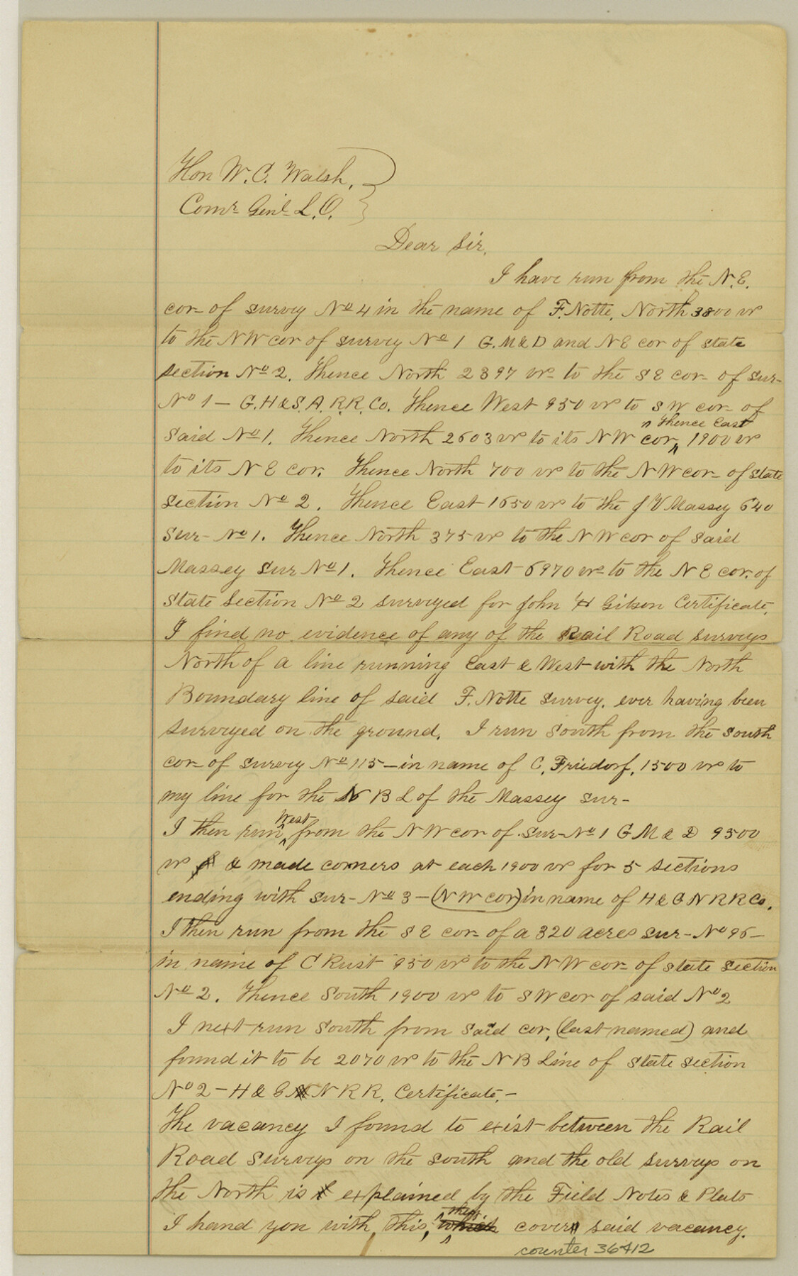
[Connecting lines from northeast corner of Nolte, Survey 4 to vicinity of Massey, Survey 1]
-
Map/Doc
36412
-
Collection
General Map Collection
-
Object Dates
1/26/1881 (File Date)
-
People and Organizations
W.L. Hayes (Surveyor/Engineer)
-
Counties
San Saba
-
Subjects
Surveying Sketch File
-
Height x Width
12.8 x 8.0 inches
32.5 x 20.3 cm
-
Medium
paper, manuscript
-
Comments
Addresses possible vacancies in area.
Related maps
San Saba County Sketch File 9

Print $22.00
- Digital $50.00
San Saba County Sketch File 9
1883
Size 12.3 x 13.7 inches
Map/Doc 36433
Part of: General Map Collection
[Neches River Bed, Plat and Calculations]
![77100, [Neches River Bed, Plat and Calculations], General Map Collection](https://historictexasmaps.com/wmedia_w700/maps/77100.tif.jpg)
Print $20.00
- Digital $50.00
[Neches River Bed, Plat and Calculations]
1928
Size 25.6 x 37.2 inches
Map/Doc 77100
Crockett County Sketch File 99

Print $14.00
- Digital $50.00
Crockett County Sketch File 99
1925
Size 14.4 x 9.4 inches
Map/Doc 19980
La Salle County Sketch File 39

Print $6.00
- Digital $50.00
La Salle County Sketch File 39
1912
Size 16.4 x 11.4 inches
Map/Doc 29592

Brooks County Working Sketch 17

Print $20.00
- Digital $50.00
Brooks County Working Sketch 17
1980
Size 38.2 x 27.7 inches
Map/Doc 67801
[Map of Block 97, Borden and Scurry Co (Exhibit A); Map of Southeastern part of Young Territory; Map of part of of Borden, Fisher, Kent, Mitchell, Scurry and Garza Cos. Showing the north boundary line of the T&P 80 mile reservation]
![65690, [Map of Block 97, Borden and Scurry Co (Exhibit A); Map of Southeastern part of Young Territory; Map of part of of Borden, Fisher, Kent, Mitchell, Scurry and Garza Cos. Showing the north boundary line of the T&P 80 mile reservation], General Map Collection](https://historictexasmaps.com/wmedia_w700/maps/65690-1.tif.jpg)
Print $40.00
- Digital $50.00
[Map of Block 97, Borden and Scurry Co (Exhibit A); Map of Southeastern part of Young Territory; Map of part of of Borden, Fisher, Kent, Mitchell, Scurry and Garza Cos. Showing the north boundary line of the T&P 80 mile reservation]
Size 58.7 x 42.4 inches
Map/Doc 65690
Morris County Rolled Sketch 2A

Print $20.00
- Digital $50.00
Morris County Rolled Sketch 2A
Size 24.3 x 18.7 inches
Map/Doc 10675
Winkler County Working Sketch 20

Print $20.00
- Digital $50.00
Winkler County Working Sketch 20
1990
Size 22.3 x 24.0 inches
Map/Doc 72614
[William Steele Survey near Copano Bay]
![2082, [William Steele Survey near Copano Bay], General Map Collection](https://historictexasmaps.com/wmedia_w700/maps/2082.tif.jpg)
Print $20.00
- Digital $50.00
[William Steele Survey near Copano Bay]
1927
Size 26.1 x 18.4 inches
Map/Doc 2082
Reeves County Rolled Sketch 33

Print $20.00
- Digital $50.00
Reeves County Rolled Sketch 33
Size 24.7 x 36.9 inches
Map/Doc 7501
Real County Sketch File 16

Print $20.00
- Digital $50.00
Real County Sketch File 16
1934
Size 23.1 x 22.1 inches
Map/Doc 12234
Sutton County Working Sketch 14

Print $40.00
- Digital $50.00
Sutton County Working Sketch 14
1972
Size 59.5 x 36.8 inches
Map/Doc 62357
You may also like
Live Oak County Sketch File 11a

Print $4.00
- Digital $50.00
Live Oak County Sketch File 11a
1876
Size 12.7 x 8.3 inches
Map/Doc 30265
Gaines County Working Sketch 34

Print $20.00
- Digital $50.00
Gaines County Working Sketch 34
1990
Size 21.0 x 20.2 inches
Map/Doc 69334
Madison County Working Sketch 4

Print $20.00
- Digital $50.00
Madison County Working Sketch 4
1973
Size 12.7 x 12.9 inches
Map/Doc 70766
Travis County Working Sketch 16

Print $20.00
- Digital $50.00
Travis County Working Sketch 16
1941
Size 17.8 x 20.5 inches
Map/Doc 69400

Jefferson County NRC Article 33.136 Sketch 9

Print $22.00
- Digital $50.00
Jefferson County NRC Article 33.136 Sketch 9
2011
Size 24.0 x 36.0 inches
Map/Doc 94517
General Highway Map, Delta County, Hopkins County, Texas

Print $20.00
General Highway Map, Delta County, Hopkins County, Texas
1940
Size 25.2 x 18.5 inches
Map/Doc 79073
Washington County

Print $20.00
- Digital $50.00
Washington County
1976
Size 31.7 x 46.5 inches
Map/Doc 73317
Texas Gulf Coast, from the Sabine River to the Rio Grande as Subdivided for Mineral Development; Matagorda, Calhoun and Aransas Counties

Print $40.00
- Digital $50.00
Texas Gulf Coast, from the Sabine River to the Rio Grande as Subdivided for Mineral Development; Matagorda, Calhoun and Aransas Counties
1976
Size 43.0 x 90.9 inches
Map/Doc 1939
Crockett County Working Sketch 86

Print $20.00
- Digital $50.00
Crockett County Working Sketch 86
1976
Size 34.7 x 38.0 inches
Map/Doc 68419
Garza County Sketch File H1

Print $24.00
- Digital $50.00
Garza County Sketch File H1
Size 7.6 x 8.8 inches
Map/Doc 24030
[Corner of Crosby, Lubbock, Lynn and Garza Counties]
![90905, [Corner of Crosby, Lubbock, Lynn and Garza Counties], Twichell Survey Records](https://historictexasmaps.com/wmedia_w700/maps/90905-1.tif.jpg)
Print $20.00
- Digital $50.00
[Corner of Crosby, Lubbock, Lynn and Garza Counties]
Size 36.0 x 22.8 inches
Map/Doc 90905