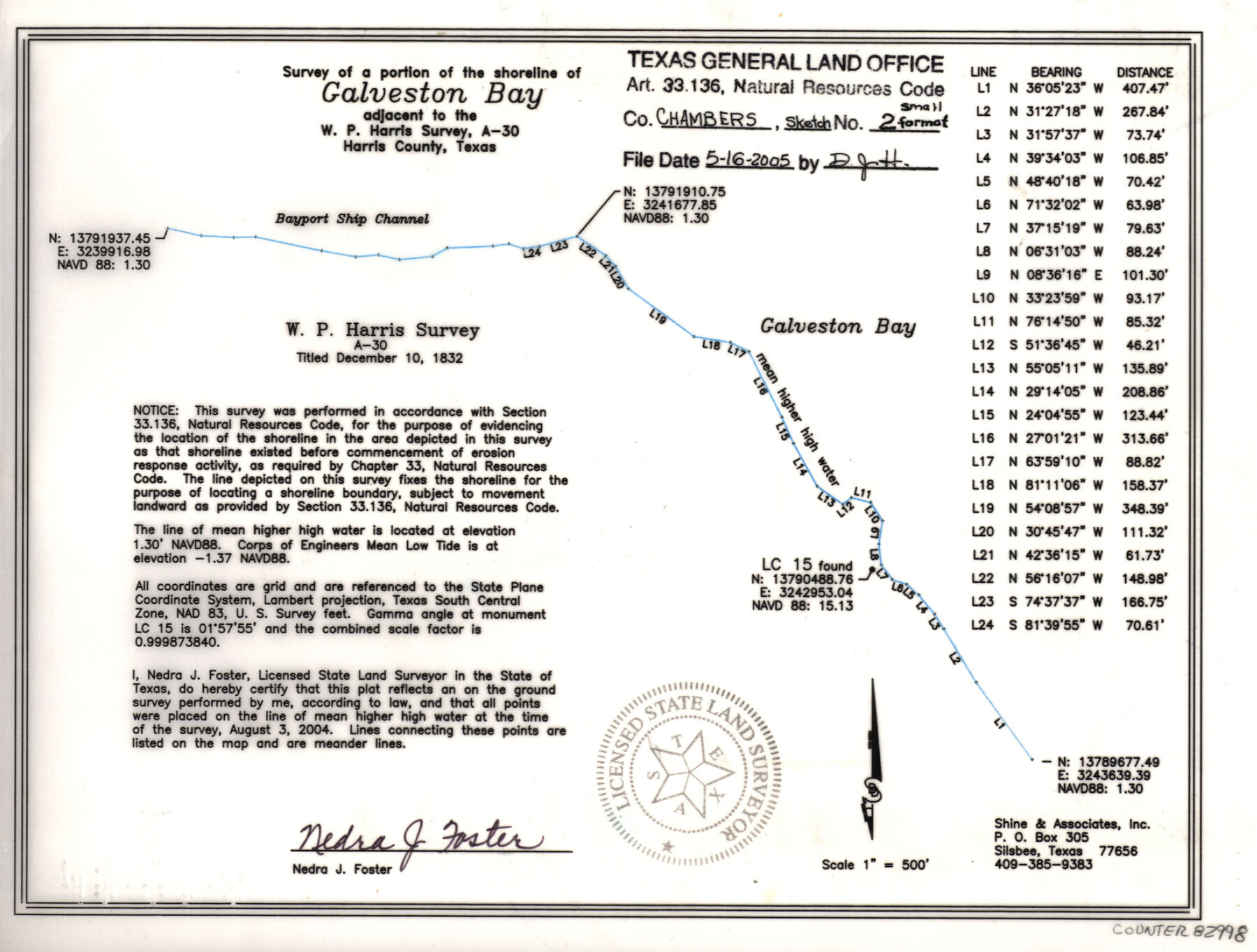
Chambers County NRC Article 33.136 Sketch 2
Survey of a Portion of the Shoreline of Galveston Bay Adjacent to W. P. Harris Survey, Abstract 30
-
Map/Doc
82998
-
Collection
General Map Collection
-
Object Dates
2004/8/3 (Creation Date)
2005/5/16 (File Date)
-
People and Organizations
Shine & Associates, Inc. (Publisher)
Shine and Associates, Inc. (Printer)
Nedra J. Foster (Surveyor/Engineer)
-
Counties
Chambers
-
Subjects
Surveying CBS
-
Height x Width
8.2 x 10.8 inches
20.8 x 27.4 cm
-
Medium
mylar, print
-
Comments
Survey located about 15 1/2 miles South 76 degrees West of Anahuca, Texas.
Part of: General Map Collection
Flight Mission No. DIX-5P, Frame 113, Aransas County

Print $20.00
- Digital $50.00
Flight Mission No. DIX-5P, Frame 113, Aransas County
1956
Size 17.6 x 17.7 inches
Map/Doc 83792
Val Verde County Sketch File 36

Print $20.00
- Digital $50.00
Val Verde County Sketch File 36
1937
Size 18.6 x 24.6 inches
Map/Doc 12577
Aransas County Sketch File 12a

Print $8.00
- Digital $50.00
Aransas County Sketch File 12a
1889
Size 14.1 x 8.8 inches
Map/Doc 13122
Henderson County Sketch File 13

Print $4.00
- Digital $50.00
Henderson County Sketch File 13
1876
Size 8.2 x 12.8 inches
Map/Doc 26353
Lampasas County Working Sketch 19

Print $40.00
- Digital $50.00
Lampasas County Working Sketch 19
1979
Size 43.8 x 48.3 inches
Map/Doc 70296
Kenedy County Rolled Sketch 18

Print $20.00
- Digital $50.00
Kenedy County Rolled Sketch 18
1995
Size 29.5 x 39.2 inches
Map/Doc 6472
Texas City Channel, Texas, Channel and Turning Basin Dredging - Sheet 3

Print $20.00
- Digital $50.00
Texas City Channel, Texas, Channel and Turning Basin Dredging - Sheet 3
1958
Size 28.4 x 40.6 inches
Map/Doc 61833
Midland County

Print $20.00
- Digital $50.00
Midland County
1930
Size 45.7 x 39.6 inches
Map/Doc 66930
Flight Mission No. DQO-13T, Frame 49, Galveston County

Print $20.00
- Digital $50.00
Flight Mission No. DQO-13T, Frame 49, Galveston County
1958
Size 18.5 x 18.4 inches
Map/Doc 85214
Bandera County Working Sketch 16a

Print $20.00
- Digital $50.00
Bandera County Working Sketch 16a
1941
Size 12.8 x 22.1 inches
Map/Doc 67609
[Map of Hardin County]
![3630, [Map of Hardin County], General Map Collection](https://historictexasmaps.com/wmedia_w700/maps/3630-2.tif.jpg)
Print $20.00
- Digital $50.00
[Map of Hardin County]
1862
Size 18.0 x 22.0 inches
Map/Doc 3630
Brazoria County Aerial Photograph Index Sheet 7

Print $20.00
- Digital $50.00
Brazoria County Aerial Photograph Index Sheet 7
1953
Size 23.9 x 19.8 inches
Map/Doc 83669
You may also like
[Sketch showing Blocks B-11, G and M-2 and 3, L, and 47, Sections 77-102]
![91733, [Sketch showing Blocks B-11, G and M-2 and 3, L, and 47, Sections 77-102], Twichell Survey Records](https://historictexasmaps.com/wmedia_w700/maps/91733-1.tif.jpg)
Print $20.00
- Digital $50.00
[Sketch showing Blocks B-11, G and M-2 and 3, L, and 47, Sections 77-102]
Size 25.4 x 18.8 inches
Map/Doc 91733
Montague County Sketch File 1

Print $40.00
- Digital $50.00
Montague County Sketch File 1
1852
Size 19.4 x 12.4 inches
Map/Doc 31709
Ward County Working Sketch 41

Print $20.00
- Digital $50.00
Ward County Working Sketch 41
1969
Size 45.3 x 31.7 inches
Map/Doc 72347
Runnels County Working Sketch 30c

Print $20.00
- Digital $50.00
Runnels County Working Sketch 30c
1959
Size 30.5 x 32.1 inches
Map/Doc 63628
Upper Galveston Bay, Houston Ship Channel, Dollar Pt. to Atkinson I.

Print $40.00
- Digital $50.00
Upper Galveston Bay, Houston Ship Channel, Dollar Pt. to Atkinson I.
1978
Size 49.3 x 36.8 inches
Map/Doc 69898
Liberty County Working Sketch 75

Print $20.00
- Digital $50.00
Liberty County Working Sketch 75
1980
Size 23.2 x 23.8 inches
Map/Doc 70535
Matagorda Light to Aransas Pass

Print $20.00
- Digital $50.00
Matagorda Light to Aransas Pass
1962
Size 35.7 x 44.8 inches
Map/Doc 73397
Flight Mission No. DQO-8K, Frame 15, Galveston County

Print $20.00
- Digital $50.00
Flight Mission No. DQO-8K, Frame 15, Galveston County
1952
Size 18.7 x 22.4 inches
Map/Doc 85138

Pecos County Working Sketch 2

Print $20.00
- Digital $50.00
Pecos County Working Sketch 2
Size 18.1 x 28.3 inches
Map/Doc 71472
Dimmit County Sketch File 61

Print $12.00
- Digital $50.00
Dimmit County Sketch File 61
1999
Size 11.4 x 8.8 inches
Map/Doc 21208
Travis County

Print $40.00
- Digital $50.00
Travis County
1936
Size 46.4 x 54.8 inches
Map/Doc 63076