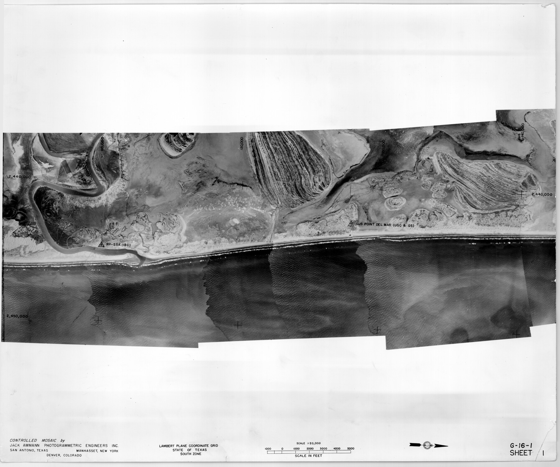
Controlled Mosaic by Jack Amman Photogrammetric Engineers, Inc - Sheet 1
[Coastal Aerial Photograph]
G-16-1
-
Map/Doc
83445
-
Collection
General Map Collection
-
Object Dates
1954 (Creation Date)
-
Subjects
Aerial Photograph
-
Height x Width
20.0 x 24.0 inches
50.8 x 61.0 cm
-
Comments
Statement on reverse side: "The reverse reflects the data shown thereon which was obtained by aerial survey made from December 31, 1953 to March 17, 1954 by Jack Ammann Photogrammetric Engineers, Inc."
Part of: General Map Collection
Flight Mission No. CUG-3P, Frame 83, Kleberg County

Print $20.00
- Digital $50.00
Flight Mission No. CUG-3P, Frame 83, Kleberg County
1956
Size 18.7 x 22.4 inches
Map/Doc 86258
G.C. & S.F. Ry. Alinement and Right of Way map of Dallas Branch, Ellis County, Texas

Print $20.00
- Digital $50.00
G.C. & S.F. Ry. Alinement and Right of Way map of Dallas Branch, Ellis County, Texas
1925
Size 30.9 x 44.2 inches
Map/Doc 64548
Carson County Boundary File 3

Print $2.00
- Digital $50.00
Carson County Boundary File 3
Size 13.3 x 8.3 inches
Map/Doc 51131
Robertson County Sketch File 10 (1)

Print $3.00
- Digital $50.00
Robertson County Sketch File 10 (1)
Size 13.0 x 10.4 inches
Map/Doc 43369
G No. 3 - Reconnaissance of the Bar and Channel of St. Marks On the Western Coast of Florida

Print $20.00
- Digital $50.00
G No. 3 - Reconnaissance of the Bar and Channel of St. Marks On the Western Coast of Florida
1852
Size 18.6 x 14.5 inches
Map/Doc 97221
Midland County

Print $20.00
- Digital $50.00
Midland County
1930
Size 44.9 x 38.5 inches
Map/Doc 73239
Flight Mission No. DQN-2K, Frame 81, Calhoun County

Print $20.00
- Digital $50.00
Flight Mission No. DQN-2K, Frame 81, Calhoun County
1953
Size 18.7 x 22.3 inches
Map/Doc 84273
Hutchinson County Working Sketch 8

Print $20.00
- Digital $50.00
Hutchinson County Working Sketch 8
1919
Size 24.8 x 16.7 inches
Map/Doc 66366
Flight Mission No. BRA-7M, Frame 138, Jefferson County

Print $20.00
- Digital $50.00
Flight Mission No. BRA-7M, Frame 138, Jefferson County
1953
Size 18.6 x 22.4 inches
Map/Doc 85532
Political Essay on the Kingdom of New Spain Vol. 3

Political Essay on the Kingdom of New Spain Vol. 3
1822
Map/Doc 97388
Mills County Working Sketch 24

Print $20.00
- Digital $50.00
Mills County Working Sketch 24
1988
Size 40.3 x 36.5 inches
Map/Doc 71054
Wilbarger County Working Sketch 22

Print $20.00
- Digital $50.00
Wilbarger County Working Sketch 22
1983
Size 39.8 x 33.6 inches
Map/Doc 72560
You may also like
Coke County Working Sketch 28

Print $20.00
- Digital $50.00
Coke County Working Sketch 28
1965
Size 32.7 x 42.2 inches
Map/Doc 68065
[Blocks D and DD, Yoakum County]
![92004, [Blocks D and DD, Yoakum County], Twichell Survey Records](https://historictexasmaps.com/wmedia_w700/maps/92004-1.tif.jpg)
Print $20.00
- Digital $50.00
[Blocks D and DD, Yoakum County]
Size 24.8 x 19.9 inches
Map/Doc 92004
Jackson County Sketch File 10

Print $26.00
- Digital $50.00
Jackson County Sketch File 10
1898
Size 11.4 x 8.6 inches
Map/Doc 27653
Nueces County Sketch File 86

Print $2.00
- Digital $50.00
Nueces County Sketch File 86
Map/Doc 81935
W. S. Mabry Land Corners and Connections, Potter County

Print $20.00
- Digital $50.00
W. S. Mabry Land Corners and Connections, Potter County
Size 22.6 x 17.5 inches
Map/Doc 91806
Fractional Township No. 7 South Range No. 1 East of the Indian Meridian, Indian Territory

Print $20.00
- Digital $50.00
Fractional Township No. 7 South Range No. 1 East of the Indian Meridian, Indian Territory
1898
Size 19.2 x 24.6 inches
Map/Doc 75199
Archer County Sketch File 29

Print $80.00
- Digital $50.00
Archer County Sketch File 29
1888
Size 21.8 x 16.5 inches
Map/Doc 10836
Aransas County NRC Article 33.136 Sketch 2

Print $26.00
- Digital $50.00
Aransas County NRC Article 33.136 Sketch 2
2001
Size 18.6 x 24.2 inches
Map/Doc 61643
Tyler County Sketch File 17b

Print $4.00
- Digital $50.00
Tyler County Sketch File 17b
Size 12.0 x 8.0 inches
Map/Doc 38666
Flight Mission No. BRE-1P, Frame 117, Nueces County

Print $20.00
- Digital $50.00
Flight Mission No. BRE-1P, Frame 117, Nueces County
1956
Size 18.4 x 22.3 inches
Map/Doc 86683
Martin County Working Sketch 15

Print $20.00
- Digital $50.00
Martin County Working Sketch 15
1975
Size 23.9 x 19.5 inches
Map/Doc 70833
Galveston County Sketch File 1b

Print $6.00
- Digital $50.00
Galveston County Sketch File 1b
1845
Size 16.2 x 11.0 inches
Map/Doc 23347