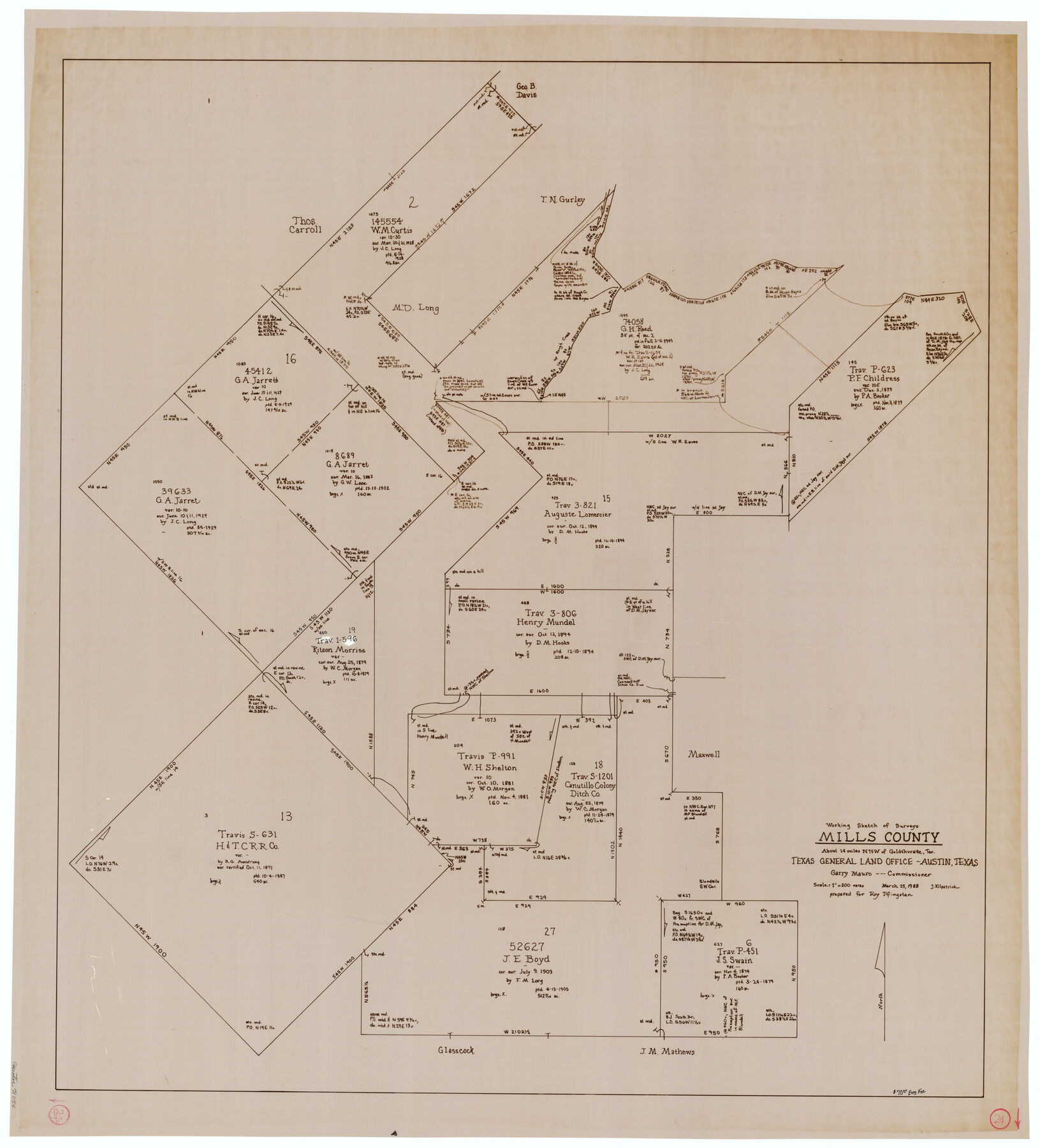
Mills County Working Sketch 24
-
Map/Doc
71054
-
Collection
General Map Collection
-
Object Dates
3/25/1988 (Creation Date)
-
People and Organizations
Joan Kilpatrick (Draftsman)
-
Counties
Mills
-
Subjects
Surveying Working Sketch
-
Height x Width
40.3 x 36.5 inches
102.4 x 92.7 cm
-
Scale
1" = 200 varas
Part of: General Map Collection
Map of Jones County

Print $20.00
- Digital $50.00
Map of Jones County
1898
Size 41.9 x 39.8 inches
Map/Doc 4996
Hutchinson County Sketch File 6a

Print $42.00
- Digital $50.00
Hutchinson County Sketch File 6a
1898
Size 7.6 x 8.6 inches
Map/Doc 27202
Supreme Court of the United States, October Term, 1930, No.2, Original - The State of New Mexico, Complainant vs. The State of Texas, Defendant

Print $138.00
- Digital $50.00
Supreme Court of the United States, October Term, 1930, No.2, Original - The State of New Mexico, Complainant vs. The State of Texas, Defendant
Size 9.2 x 6.0 inches
Map/Doc 95287
Dallas County Boundary File 6c

Print $4.00
- Digital $50.00
Dallas County Boundary File 6c
Size 14.0 x 8.6 inches
Map/Doc 52227
Wise County Sketch File 47

Print $4.00
- Digital $50.00
Wise County Sketch File 47
1888
Size 8.8 x 12.8 inches
Map/Doc 40607
Hardin County Sketch File 30

Print $6.00
- Digital $50.00
Hardin County Sketch File 30
Size 6.5 x 8.1 inches
Map/Doc 25157
Childress County Rolled Sketch 11

Print $20.00
- Digital $50.00
Childress County Rolled Sketch 11
1940
Size 45.3 x 12.0 inches
Map/Doc 8602
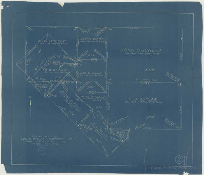
Collin County Working Sketch 2
Print $20.00
- Digital $50.00
Collin County Working Sketch 2
1926
Size 15.2 x 17.7 inches
Map/Doc 68096
Caddo Lake Subdivision, Copied from Sketch in MF 000964

Print $20.00
- Digital $50.00
Caddo Lake Subdivision, Copied from Sketch in MF 000964
1918
Size 32.5 x 28.0 inches
Map/Doc 1929
Dickens County

Print $20.00
- Digital $50.00
Dickens County
1915
Size 42.4 x 39.3 inches
Map/Doc 4722
San Augustine County Sketch File 8

Print $4.00
San Augustine County Sketch File 8
1858
Size 6.2 x 7.8 inches
Map/Doc 35648
Sulphur River, Bassett Sheet

Print $6.00
- Digital $50.00
Sulphur River, Bassett Sheet
1939
Size 23.9 x 31.2 inches
Map/Doc 65176
You may also like
Andrews County Working Sketch 5

Print $20.00
- Digital $50.00
Andrews County Working Sketch 5
1954
Size 21.7 x 43.0 inches
Map/Doc 67051
Right of Way and Track Map, the Missouri, Kansas and Texas Ry. of Texas - Henrietta Division

Print $20.00
- Digital $50.00
Right of Way and Track Map, the Missouri, Kansas and Texas Ry. of Texas - Henrietta Division
1918
Size 11.8 x 26.9 inches
Map/Doc 64748
Hudspeth County Working Sketch 28

Print $20.00
- Digital $50.00
Hudspeth County Working Sketch 28
1972
Size 29.2 x 31.3 inches
Map/Doc 66310
[Sketch for Mineral Application 26542 - Sabine River between Prairie and Hawkins Creek, F. B. Jackson, Jr.]
![65669, [Sketch for Mineral Application 26542 - Sabine River between Prairie and Hawkins Creek, F. B. Jackson, Jr.], General Map Collection](https://historictexasmaps.com/wmedia_w700/maps/65669.tif.jpg)
Print $40.00
- Digital $50.00
[Sketch for Mineral Application 26542 - Sabine River between Prairie and Hawkins Creek, F. B. Jackson, Jr.]
1931
Size 22.0 x 64.0 inches
Map/Doc 65669
Pressler's Map of Texas

Print $2.00
- Digital $50.00
Pressler's Map of Texas
1867
Size 9.0 x 6.0 inches
Map/Doc 93920
The Mexican Municipality of Colorado. Created, January 11, 1836

Print $20.00
The Mexican Municipality of Colorado. Created, January 11, 1836
2020
Size 15.7 x 21.6 inches
Map/Doc 96019
Lampasas County Working Sketch Graphic Index

Print $20.00
- Digital $50.00
Lampasas County Working Sketch Graphic Index
1972
Size 34.6 x 42.0 inches
Map/Doc 76614
Geographically Correct Map of United States showing the Union Pacific System - Union Pacific R.R. Co., Oregon Short Line R.R. Co., Oregon-Washington R.R. & Nav. Co., Los Angeles & Salt Lake R.R. Co., St. Joseph & Grand Island Ry. Co. and connections

Print $20.00
- Digital $50.00
Geographically Correct Map of United States showing the Union Pacific System - Union Pacific R.R. Co., Oregon Short Line R.R. Co., Oregon-Washington R.R. & Nav. Co., Los Angeles & Salt Lake R.R. Co., St. Joseph & Grand Island Ry. Co. and connections
1922
Size 18.2 x 32.2 inches
Map/Doc 95771
Copy of Surveyor's Field Book, Morris Browning - In Blocks 7, 5 & 4, I&GNRRCo., Hutchinson and Carson Counties, Texas

Print $2.00
- Digital $50.00
Copy of Surveyor's Field Book, Morris Browning - In Blocks 7, 5 & 4, I&GNRRCo., Hutchinson and Carson Counties, Texas
1888
Size 7.0 x 8.8 inches
Map/Doc 62259
Midland County, Texas

Print $20.00
- Digital $50.00
Midland County, Texas
1880
Size 25.5 x 21.5 inches
Map/Doc 740
Webb County Working Sketch 4

Print $20.00
- Digital $50.00
Webb County Working Sketch 4
1907
Size 45.6 x 42.5 inches
Map/Doc 72369
Dallam County Working Sketch 3

Print $20.00
- Digital $50.00
Dallam County Working Sketch 3
1960
Size 13.8 x 30.5 inches
Map/Doc 68588