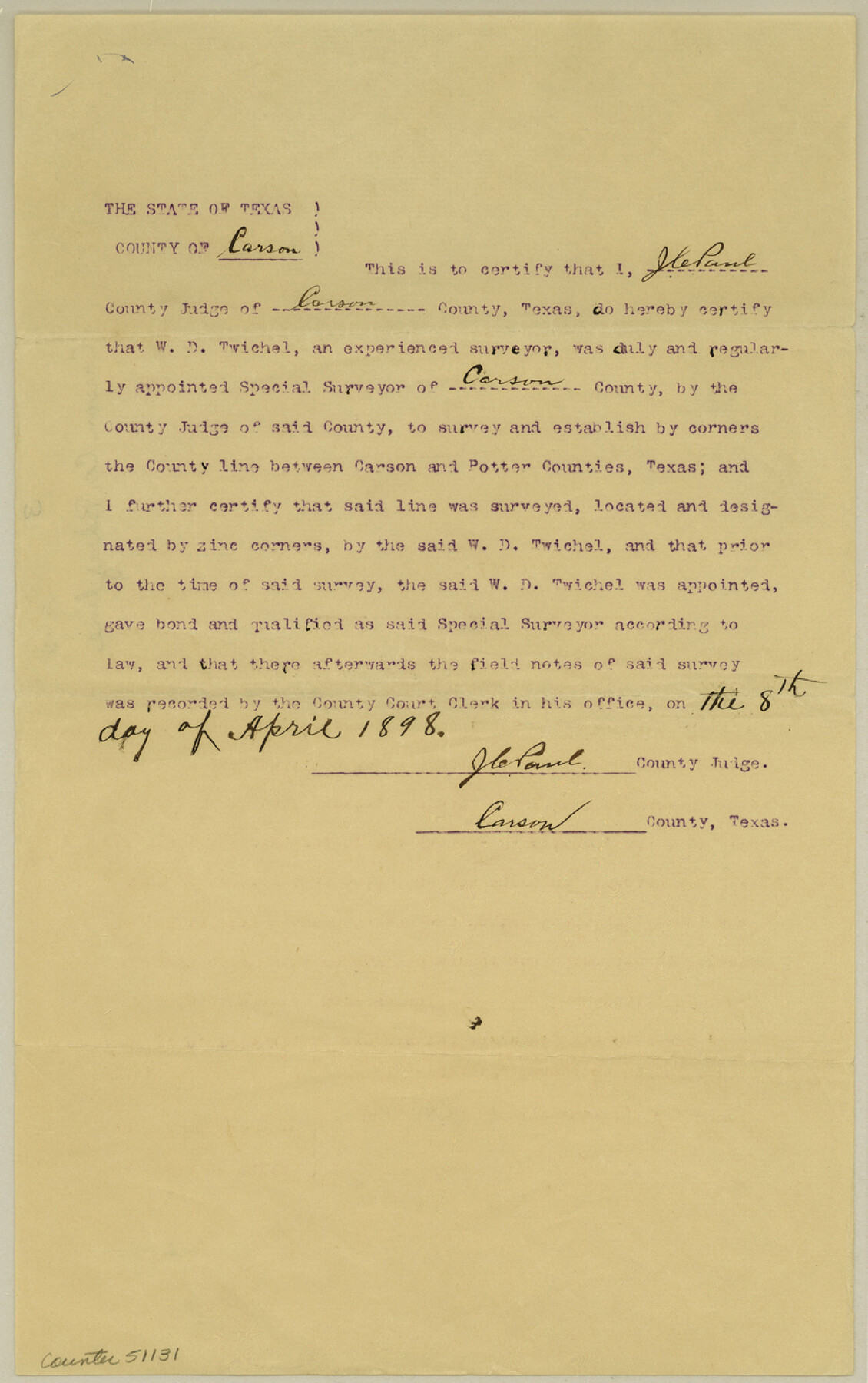
Carson County Boundary File 3
[Certificate of Appointment]
-
Map/Doc
51131
-
Collection
General Map Collection
-
Counties
Carson
-
Subjects
County Boundaries
-
Height x Width
13.3 x 8.3 inches
33.8 x 21.1 cm
Part of: General Map Collection

Flight Mission No. BRE-1P, Frame 105, Nueces County

Print $20.00
- Digital $50.00
Flight Mission No. BRE-1P, Frame 105, Nueces County
1956
Size 18.4 x 22.2 inches
Map/Doc 86676
Flight Mission No. CUG-3P, Frame 24, Kleberg County

Print $20.00
- Digital $50.00
Flight Mission No. CUG-3P, Frame 24, Kleberg County
1956
Size 18.4 x 22.3 inches
Map/Doc 86234
Flight Mission No. DQN-2K, Frame 98, Calhoun County

Print $20.00
- Digital $50.00
Flight Mission No. DQN-2K, Frame 98, Calhoun County
1953
Size 18.7 x 22.4 inches
Map/Doc 84288
Reagan County Working Sketch 32

Print $20.00
- Digital $50.00
Reagan County Working Sketch 32
1965
Size 43.9 x 37.1 inches
Map/Doc 71874
Padre Island National Seashore, Texas - Dependent Resurvey

Print $4.00
- Digital $50.00
Padre Island National Seashore, Texas - Dependent Resurvey
2001
Size 18.3 x 24.2 inches
Map/Doc 60546
Flight Mission No. BQY-15M, Frame 21, Harris County

Print $20.00
- Digital $50.00
Flight Mission No. BQY-15M, Frame 21, Harris County
1953
Size 18.7 x 22.3 inches
Map/Doc 85319
Cameron County Boundary File 1

Print $14.00
- Digital $50.00
Cameron County Boundary File 1
Size 14.1 x 8.6 inches
Map/Doc 51087
Travis County Boundary File 30

Print $4.00
- Digital $50.00
Travis County Boundary File 30
Size 10.4 x 8.6 inches
Map/Doc 59469
Flight Mission No. BRE-2P, Frame 80, Nueces County

Print $20.00
- Digital $50.00
Flight Mission No. BRE-2P, Frame 80, Nueces County
1956
Size 18.4 x 22.5 inches
Map/Doc 86775

Parker County Working Sketch 13

Print $20.00
- Digital $50.00
Parker County Working Sketch 13
1978
Map/Doc 71463
You may also like
Live Oak County Working Sketch 28

Print $20.00
- Digital $50.00
Live Oak County Working Sketch 28
1982
Size 33.3 x 21.1 inches
Map/Doc 70613
Jeff Davis County Working Sketch 25

Print $20.00
- Digital $50.00
Jeff Davis County Working Sketch 25
1959
Size 28.9 x 32.2 inches
Map/Doc 66520
Calhoun County Working Sketch 9

Print $20.00
- Digital $50.00
Calhoun County Working Sketch 9
1948
Size 45.3 x 43.1 inches
Map/Doc 67825
Lubbock County Sketch File 8

Print $8.00
- Digital $50.00
Lubbock County Sketch File 8
1907
Size 11.1 x 8.5 inches
Map/Doc 30426
Map of Chicago, Rock Island & Texas Railway

Print $20.00
- Digital $50.00
Map of Chicago, Rock Island & Texas Railway
1892
Size 22.4 x 44.0 inches
Map/Doc 64443
Eastland County Sketch File 17

Print $18.00
- Digital $50.00
Eastland County Sketch File 17
1918
Size 13.6 x 8.9 inches
Map/Doc 21600
Loving County Working Sketch 26

Print $40.00
- Digital $50.00
Loving County Working Sketch 26
2014
Size 33.3 x 48.0 inches
Map/Doc 93681
Dickens County Sketch File 6a

Print $6.00
- Digital $50.00
Dickens County Sketch File 6a
1882
Size 16.5 x 9.4 inches
Map/Doc 20969
Schleicher County Sketch File 13

Print $10.00
- Digital $50.00
Schleicher County Sketch File 13
1916
Size 14.4 x 8.9 inches
Map/Doc 36493
Presidio County Working Sketch Graphic Index, South Part, Sheet 2 (Sketches 45 to Most Recent)

Print $20.00
- Digital $50.00
Presidio County Working Sketch Graphic Index, South Part, Sheet 2 (Sketches 45 to Most Recent)
1975
Size 32.4 x 37.9 inches
Map/Doc 76671
Smith County Sketch File 6

Print $4.00
- Digital $50.00
Smith County Sketch File 6
1848
Size 7.2 x 8.6 inches
Map/Doc 36757
Kenedy County Aerial Photograph Index Sheet 5

Print $20.00
- Digital $50.00
Kenedy County Aerial Photograph Index Sheet 5
1943
Size 23.5 x 19.6 inches
Map/Doc 89046