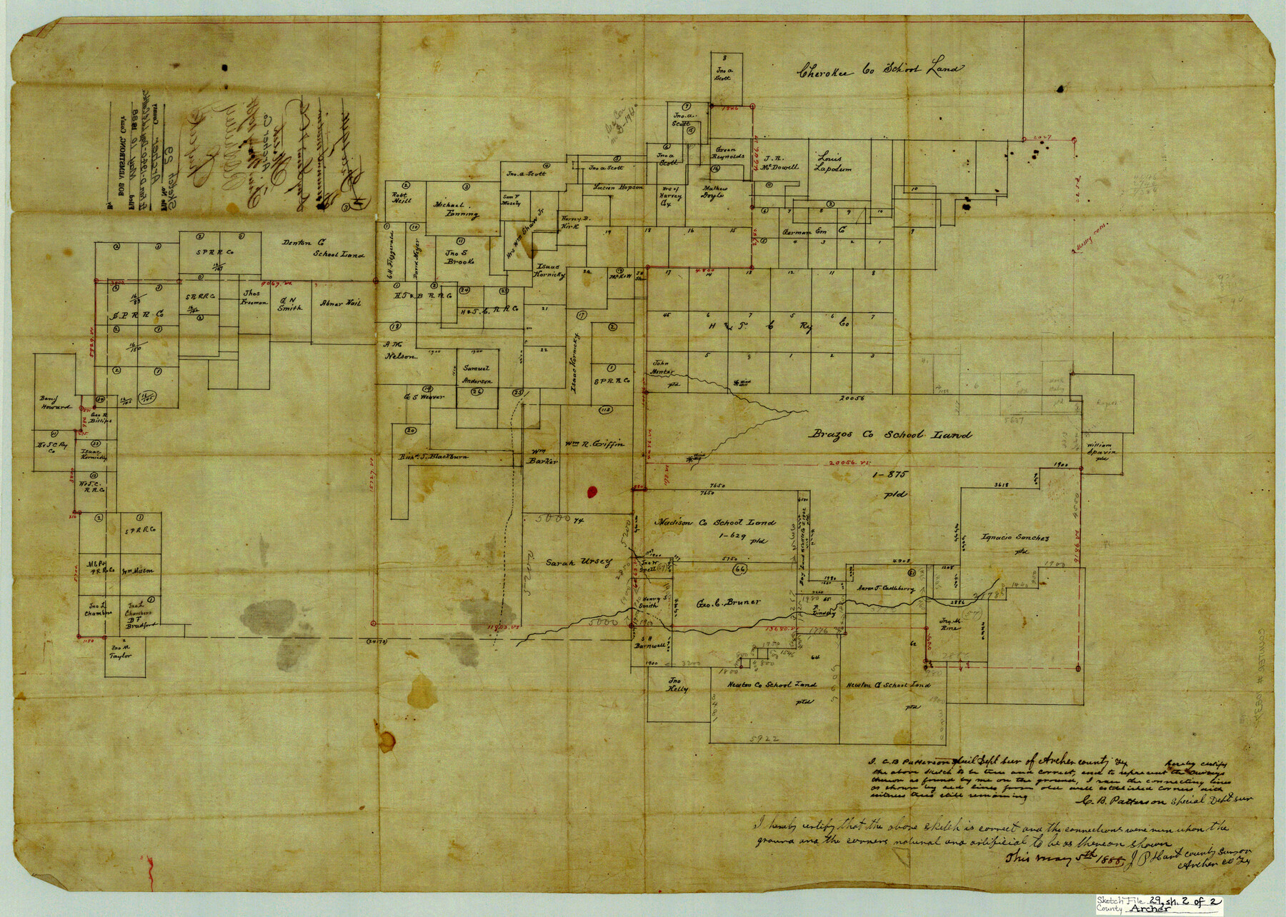
Archer County Sketch File 29
[Multiple sketches in Archer County]
-
Map/Doc
10836
-
Collection
General Map Collection
-
Object Dates
1888/5/5 (Creation Date)
1888/5/10 (File Date)
-
People and Organizations
T.M. Cecil (Surveyor/Engineer)
C.B. Patterson (Surveyor/Engineer)
-
Counties
Archer
-
Subjects
Surveying Sketch File
-
Height x Width
21.8 x 16.5 inches
55.4 x 41.9 cm
-
Medium
linen, manuscript
-
Comments
Sketches transferred from Fannin B-1940.
Part of: General Map Collection
North Sulphur River, Sims Crossing Sheet

Print $20.00
- Digital $50.00
North Sulphur River, Sims Crossing Sheet
1924
Size 23.4 x 39.9 inches
Map/Doc 65167
Collin County Boundary File 2

Print $6.00
- Digital $50.00
Collin County Boundary File 2
Size 12.9 x 8.0 inches
Map/Doc 51682
Cameron County Sketch File 3

Print $42.00
- Digital $50.00
Cameron County Sketch File 3
1930
Size 11.1 x 8.8 inches
Map/Doc 17023
Hays County Working Sketch 8

Print $20.00
- Digital $50.00
Hays County Working Sketch 8
1942
Size 27.1 x 30.9 inches
Map/Doc 66082
Gaines County Working Sketch 19

Print $20.00
- Digital $50.00
Gaines County Working Sketch 19
1970
Size 46.0 x 37.5 inches
Map/Doc 69319
Flight Mission No. BRE-2P, Frame 123, Nueces County

Print $20.00
- Digital $50.00
Flight Mission No. BRE-2P, Frame 123, Nueces County
1956
Size 18.5 x 22.4 inches
Map/Doc 86799
Bastrop County Working Sketch 6

Print $20.00
- Digital $50.00
Bastrop County Working Sketch 6
1923
Size 37.5 x 31.2 inches
Map/Doc 67306
No. 1 - Survey for a road from the Brazo Santiago to the Rio Grande

Print $20.00
- Digital $50.00
No. 1 - Survey for a road from the Brazo Santiago to the Rio Grande
1847
Size 18.3 x 27.0 inches
Map/Doc 72873
[Gulf, Colorado & Santa Fe Railway line through Fort Bend Co.]
![64212, [Gulf, Colorado & Santa Fe Railway line through Fort Bend Co.], General Map Collection](https://historictexasmaps.com/wmedia_w700/maps/64212.tif.jpg)
Print $20.00
- Digital $50.00
[Gulf, Colorado & Santa Fe Railway line through Fort Bend Co.]
1898
Size 14.2 x 33.5 inches
Map/Doc 64212
Flight Mission No. DAG-24K, Frame 51, Matagorda County

Print $20.00
- Digital $50.00
Flight Mission No. DAG-24K, Frame 51, Matagorda County
1953
Size 16.0 x 15.9 inches
Map/Doc 86538
Frio County Rolled Sketch 22

Print $20.00
- Digital $50.00
Frio County Rolled Sketch 22
1962
Size 16.4 x 24.6 inches
Map/Doc 5923
Flight Mission No. BQR-22K, Frame 42, Brazoria County

Print $20.00
- Digital $50.00
Flight Mission No. BQR-22K, Frame 42, Brazoria County
1953
Size 18.9 x 22.7 inches
Map/Doc 84126
You may also like

Flight Mission No. DQO-8K, Frame 43, Galveston County

Print $20.00
- Digital $50.00
Flight Mission No. DQO-8K, Frame 43, Galveston County
1952
Size 18.6 x 22.3 inches
Map/Doc 85150
Map of Bee County

Print $20.00
- Digital $50.00
Map of Bee County
1879
Size 25.3 x 22.8 inches
Map/Doc 3288
Red River County Working Sketch 74

Print $20.00
- Digital $50.00
Red River County Working Sketch 74
1980
Size 24.2 x 22.8 inches
Map/Doc 72057
Victoria County Sketch File 3

Print $7.00
- Digital $50.00
Victoria County Sketch File 3
1876
Size 10.1 x 8.2 inches
Map/Doc 39514
[H. &GN Blk. 2, HGN Blk. 1, I, S]
![93212, [H. &GN Blk. 2, HGN Blk. 1, I, S], Twichell Survey Records](https://historictexasmaps.com/wmedia_w700/maps/93212-1.tif.jpg)
Print $40.00
- Digital $50.00
[H. &GN Blk. 2, HGN Blk. 1, I, S]
Size 84.0 x 53.3 inches
Map/Doc 93212
Map of Collingsworth County

Print $20.00
- Digital $50.00
Map of Collingsworth County
1899
Size 41.1 x 38.6 inches
Map/Doc 4738
[G. C. & S. F. Ry. Co. Block H, E. L. & R. R. Ry. Co. Block D7 and vicinity]
![91864, [G. C. & S. F. Ry. Co. Block H, E. L. & R. R. Ry. Co. Block D7 and vicinity], Twichell Survey Records](https://historictexasmaps.com/wmedia_w700/maps/91864-1.tif.jpg)
Print $20.00
- Digital $50.00
[G. C. & S. F. Ry. Co. Block H, E. L. & R. R. Ry. Co. Block D7 and vicinity]
Size 15.0 x 18.5 inches
Map/Doc 91864
Current Miscellaneous File 65

Print $8.00
- Digital $50.00
Current Miscellaneous File 65
Size 11.2 x 8.6 inches
Map/Doc 74109
[Hockley, Lubbock, Terry and Lynn Corner]
![92889, [Hockley, Lubbock, Terry and Lynn Corner], Twichell Survey Records](https://historictexasmaps.com/wmedia_w700/maps/92889-1.tif.jpg)
Print $20.00
- Digital $50.00
[Hockley, Lubbock, Terry and Lynn Corner]
Size 17.6 x 15.6 inches
Map/Doc 92889
Padre Island National Seashore

Print $4.00
- Digital $50.00
Padre Island National Seashore
Size 16.1 x 22.3 inches
Map/Doc 60535
Baylor County Rolled Sketch 5

Print $20.00
- Digital $50.00
Baylor County Rolled Sketch 5
1874
Size 43.2 x 39.7 inches
Map/Doc 8444