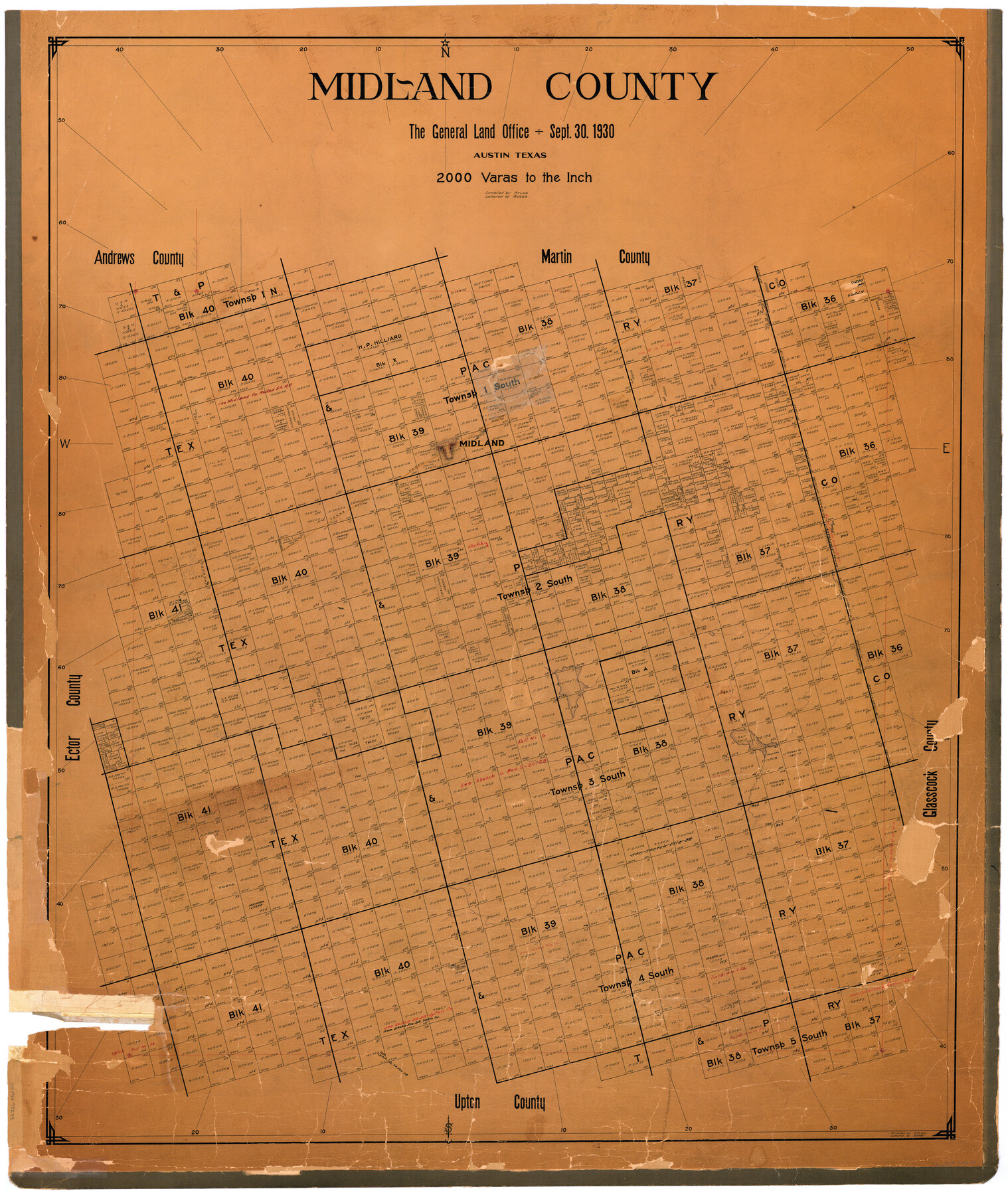
Midland County
-
Map/Doc
73239
-
Collection
General Map Collection
-
Object Dates
1930/9/30 (Creation Date)
-
People and Organizations
Texas General Land Office (Publisher)
Tom G. Atlee (Compiler)
Boggs (Draftsman)
-
Counties
Midland
-
Subjects
County
-
Height x Width
44.9 x 38.5 inches
114.0 x 97.8 cm
-
Comments
Hand lettered.
-
Features
Mustang Creek
Midland
T&P
Salt Lake
Part of: General Map Collection
Burnet County Sketch File 25

Print $4.00
- Digital $50.00
Burnet County Sketch File 25
1873
Size 8.1 x 8.6 inches
Map/Doc 16725
Knox County Rolled Sketch 14

Print $40.00
- Digital $50.00
Knox County Rolled Sketch 14
1892
Size 21.8 x 54.9 inches
Map/Doc 10666
Hardeman County Boundary File 3a

Print $42.00
- Digital $50.00
Hardeman County Boundary File 3a
Size 56.8 x 12.3 inches
Map/Doc 54384
Hale County Sketch File 4

Print $20.00
- Digital $50.00
Hale County Sketch File 4
1891
Size 18.8 x 16.4 inches
Map/Doc 11594
Map of Tom Green County

Print $40.00
- Digital $50.00
Map of Tom Green County
1892
Size 42.9 x 48.2 inches
Map/Doc 63069
Flight Mission No. DIX-5P, Frame 151, Aransas County

Print $20.00
- Digital $50.00
Flight Mission No. DIX-5P, Frame 151, Aransas County
1956
Size 17.8 x 18.2 inches
Map/Doc 83813
Floyd County Sketch File 17

Print $12.00
- Digital $50.00
Floyd County Sketch File 17
1913
Size 8.3 x 5.4 inches
Map/Doc 22747
[Right of Way Map, Belton Branch of the M.K.&T. RR.]
![64224, [Right of Way Map, Belton Branch of the M.K.&T. RR.], General Map Collection](https://historictexasmaps.com/wmedia_w700/maps/64224.tif.jpg)
Print $20.00
- Digital $50.00
[Right of Way Map, Belton Branch of the M.K.&T. RR.]
1896
Size 7.1 x 20.6 inches
Map/Doc 64224
Real County Working Sketch 7

Print $20.00
- Digital $50.00
Real County Working Sketch 7
1928
Size 18.4 x 19.4 inches
Map/Doc 71899
Crockett County Rolled Sketch 58

Print $20.00
- Digital $50.00
Crockett County Rolled Sketch 58
Size 19.0 x 32.8 inches
Map/Doc 5600
Grayson County Sketch File 9

Print $4.00
- Digital $50.00
Grayson County Sketch File 9
1857
Size 12.1 x 8.1 inches
Map/Doc 24472
Dimmit County Working Sketch 26

Print $20.00
- Digital $50.00
Dimmit County Working Sketch 26
1956
Size 19.3 x 15.9 inches
Map/Doc 68687
You may also like
Map of the Houston & Texas Centr. R.R. from Corsicana, Navarro County, to Dallas, Dallas County

Print $40.00
- Digital $50.00
Map of the Houston & Texas Centr. R.R. from Corsicana, Navarro County, to Dallas, Dallas County
Size 27.6 x 88.3 inches
Map/Doc 64041
Amistad International Reservoir on Rio Grande 84

Print $20.00
- Digital $50.00
Amistad International Reservoir on Rio Grande 84
1949
Size 28.4 x 40.2 inches
Map/Doc 75513
DeWitt Empresario Colony. April 15, 1825

Print $20.00
DeWitt Empresario Colony. April 15, 1825
2020
Size 18.1 x 21.7 inches
Map/Doc 95991
Maps showing Arkansas Central, the Helena & Corinth, and the Pine Bluff & Southwestern Railroads together forming the Texas & Northeastern Railway.

Print $20.00
Maps showing Arkansas Central, the Helena & Corinth, and the Pine Bluff & Southwestern Railroads together forming the Texas & Northeastern Railway.
1872
Size 26.8 x 29.1 inches
Map/Doc 93609
Jeff Davis County Sketch File 9

Print $40.00
- Digital $50.00
Jeff Davis County Sketch File 9
Size 15.1 x 17.6 inches
Map/Doc 27920
[Blocks 2, 3, 4, 7, and B2]
![90754, [Blocks 2, 3, 4, 7, and B2], Twichell Survey Records](https://historictexasmaps.com/wmedia_w700/maps/90754-1.tif.jpg)
Print $20.00
- Digital $50.00
[Blocks 2, 3, 4, 7, and B2]
1882
Size 20.0 x 25.6 inches
Map/Doc 90754
General Highway Map, Marion County, Texas

Print $20.00
General Highway Map, Marion County, Texas
1961
Size 18.2 x 24.6 inches
Map/Doc 79582
[Pencil sketch of Wm. Rivers survey]
![91968, [Pencil sketch of Wm. Rivers survey], Twichell Survey Records](https://historictexasmaps.com/wmedia_w700/maps/91968-1.tif.jpg)
Print $3.00
- Digital $50.00
[Pencil sketch of Wm. Rivers survey]
Size 10.1 x 16.5 inches
Map/Doc 91968
Dickens County Rolled Sketch 13

Print $40.00
- Digital $50.00
Dickens County Rolled Sketch 13
1950
Size 44.3 x 53.8 inches
Map/Doc 44296
Sketch of work done by Erath and Green in August 1846 on the north fork of Cow Bayou

Print $2.00
- Digital $50.00
Sketch of work done by Erath and Green in August 1846 on the north fork of Cow Bayou
1846
Size 9.8 x 7.9 inches
Map/Doc 78373
Right-of-Way and Track Map, Texas State Railroad operated by the T. and N. O. R.R. Co.

Print $40.00
- Digital $50.00
Right-of-Way and Track Map, Texas State Railroad operated by the T. and N. O. R.R. Co.
1917
Size 24.6 x 55.8 inches
Map/Doc 64175
Lynn County Boundary File 10

Print $110.00
- Digital $50.00
Lynn County Boundary File 10
Size 14.3 x 8.7 inches
Map/Doc 56709