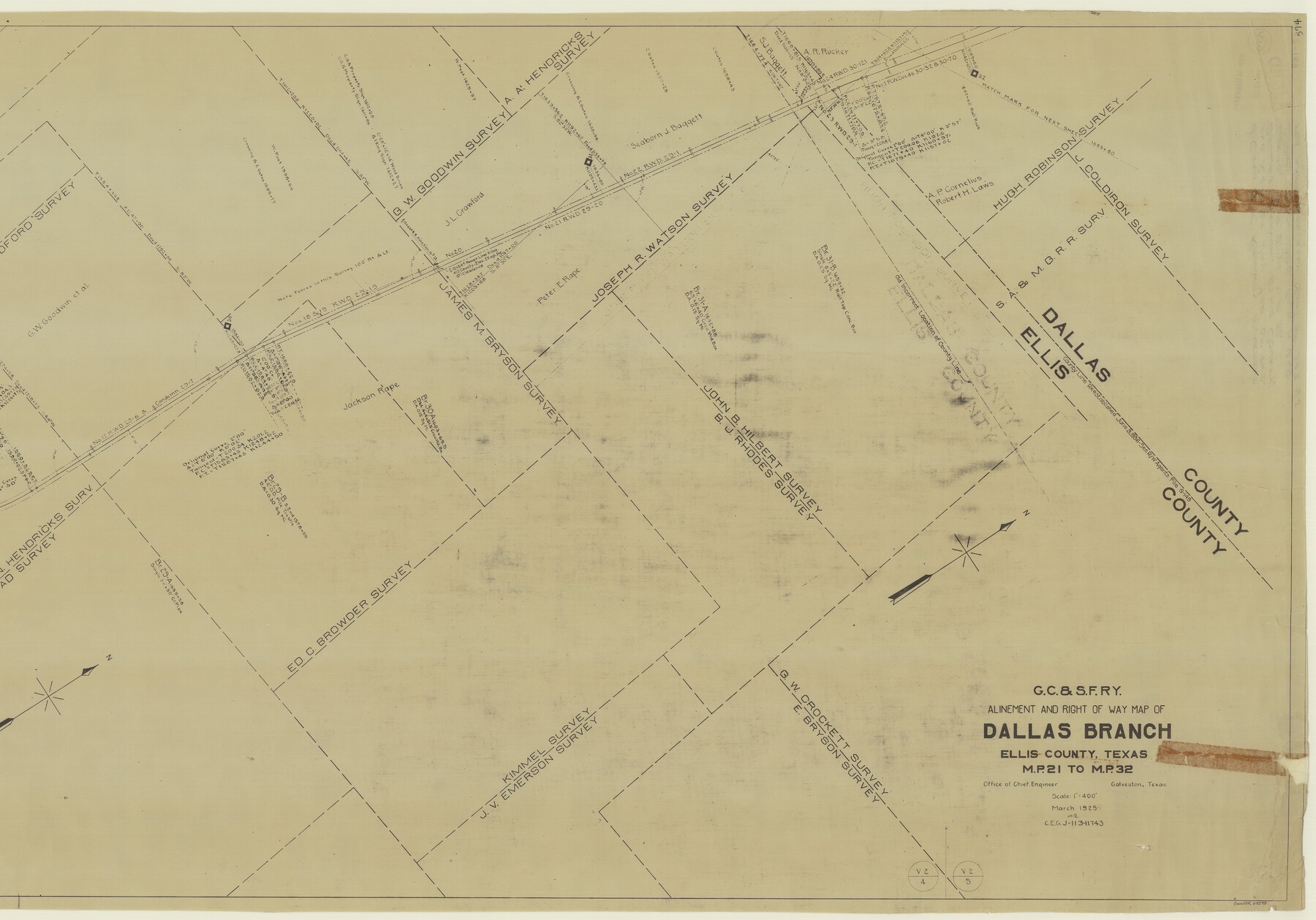
G.C. & S.F. Ry. Alinement and Right of Way map of Dallas Branch, Ellis County, Texas
M.P. 21 to M.P. 32
Z-2-169
-
Map/Doc
64548
-
Collection
General Map Collection
-
Object Dates
1925 (Creation Date)
1943/9/8 (File Date)
-
Counties
Ellis Johnson
-
Subjects
Railroads
-
Height x Width
30.9 x 44.2 inches
78.5 x 112.3 cm
-
Medium
blueprint/diazo
-
Scale
1" = 400 feet
-
Comments
For reference only; Mile Post 21 to Mile Post 32.
Segment 2; see counter no. 64547 for segment 1. -
Features
GC&SF
Elm Creek
Wyatt
Soap Creek
Sutton Branch [of Soap Creek]
Midlothian
[Railroad line] to Fort Worth
Part of: General Map Collection
Ward County Rolled Sketch 15

Print $20.00
- Digital $50.00
Ward County Rolled Sketch 15
1941
Size 26.9 x 39.2 inches
Map/Doc 8158
Donley County Sketch File 27

Print $4.00
- Digital $50.00
Donley County Sketch File 27
Size 7.7 x 12.1 inches
Map/Doc 21264
Reagan County Working Sketch 19

Print $20.00
- Digital $50.00
Reagan County Working Sketch 19
1954
Size 24.3 x 42.9 inches
Map/Doc 71861
Blanco County Working Sketch 32

Print $20.00
- Digital $50.00
Blanco County Working Sketch 32
1972
Size 31.8 x 32.2 inches
Map/Doc 67392
Reagan County Sketch File 23

Print $24.00
- Digital $50.00
Reagan County Sketch File 23
1939
Size 11.3 x 8.8 inches
Map/Doc 35016
San Patricio County Rolled Sketch 52

Print $20.00
- Digital $50.00
San Patricio County Rolled Sketch 52
1994
Size 36.7 x 39.4 inches
Map/Doc 7737
Brown County Sketch File 21

Print $40.00
- Digital $50.00
Brown County Sketch File 21
Size 16.4 x 12.8 inches
Map/Doc 11021
Boundary Between the United States & Mexico Agreed Upon by the Joint Commission under the Treaty of Guadalupe Hidalgo

Print $20.00
- Digital $50.00
Boundary Between the United States & Mexico Agreed Upon by the Joint Commission under the Treaty of Guadalupe Hidalgo
1853
Size 17.7 x 23.8 inches
Map/Doc 65392
Wichita County Sketch File 12

Print $6.00
- Digital $50.00
Wichita County Sketch File 12
1881
Size 10.2 x 8.3 inches
Map/Doc 40074
Ellis County Boundary File 4

Print $14.00
- Digital $50.00
Ellis County Boundary File 4
Size 14.2 x 8.6 inches
Map/Doc 52983
Flight Mission No. BRA-16M, Frame 125, Jefferson County

Print $20.00
- Digital $50.00
Flight Mission No. BRA-16M, Frame 125, Jefferson County
1953
Size 18.5 x 22.6 inches
Map/Doc 85735
Travis County State Real Property Sketch 4

Print $20.00
- Digital $50.00
Travis County State Real Property Sketch 4
1987
Size 25.7 x 30.7 inches
Map/Doc 61695
You may also like
Working Sketch Compiled From Original Field Notes Showing Surveys in Reagan and Irion Counties

Print $20.00
- Digital $50.00
Working Sketch Compiled From Original Field Notes Showing Surveys in Reagan and Irion Counties
Size 36.2 x 20.2 inches
Map/Doc 92331
Dimmit County Sketch File 20 1/2

Print $43.00
- Digital $50.00
Dimmit County Sketch File 20 1/2
Size 9.0 x 8.6 inches
Map/Doc 21104
General Highway Map. Detail of Cities and Towns in Williamson County, Texas [Round Rock, Taylor, Georgetown]
![79714, General Highway Map. Detail of Cities and Towns in Williamson County, Texas [Round Rock, Taylor, Georgetown], Texas State Library and Archives](https://historictexasmaps.com/wmedia_w700/maps/79714.tif.jpg)
Print $20.00
General Highway Map. Detail of Cities and Towns in Williamson County, Texas [Round Rock, Taylor, Georgetown]
1961
Size 18.2 x 24.8 inches
Map/Doc 79714
Upton County Rolled Sketch 60

Print $20.00
- Digital $50.00
Upton County Rolled Sketch 60
2021
Size 35.9 x 24.0 inches
Map/Doc 96569
General Chart of the Coast No. XXI Gulf Coast from Galveston to the Rio Grande

Print $20.00
- Digital $50.00
General Chart of the Coast No. XXI Gulf Coast from Galveston to the Rio Grande
1883
Size 27.2 x 18.3 inches
Map/Doc 72728
Brazoria County Sketch File 46

Print $48.00
- Digital $50.00
Brazoria County Sketch File 46
1925
Size 14.3 x 8.8 inches
Map/Doc 15082
Brown County Working Sketch 12

Print $20.00
- Digital $50.00
Brown County Working Sketch 12
1984
Size 27.0 x 25.2 inches
Map/Doc 67777
Kleberg County Rolled Sketch 10-10

Print $20.00
- Digital $50.00
Kleberg County Rolled Sketch 10-10
1951
Size 38.7 x 32.7 inches
Map/Doc 9389
Galveston County Rolled Sketch DB

Print $20.00
- Digital $50.00
Galveston County Rolled Sketch DB
Size 37.0 x 47.5 inches
Map/Doc 9854
Houston County Sketch File 34

Print $6.00
- Digital $50.00
Houston County Sketch File 34
1914
Size 13.3 x 11.0 inches
Map/Doc 26811
[West line of Randall County]
![91705, [West line of Randall County], Twichell Survey Records](https://historictexasmaps.com/wmedia_w700/maps/91705-1.tif.jpg)
Print $20.00
- Digital $50.00
[West line of Randall County]
Size 4.2 x 19.9 inches
Map/Doc 91705
Flight Mission No. BQY-4M, Frame 124, Harris County

Print $20.00
- Digital $50.00
Flight Mission No. BQY-4M, Frame 124, Harris County
1953
Size 18.7 x 22.4 inches
Map/Doc 85292