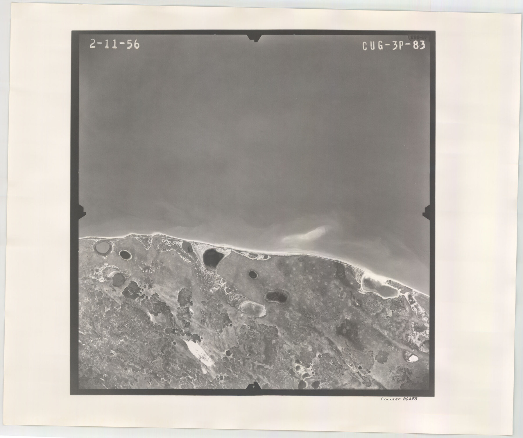
Flight Mission No. CUG-3P, Frame 83, Kleberg County
CUG-3P-83
-
Map/Doc
86258
-
Collection
General Map Collection
-
Object Dates
1956/2/11 (Creation Date)
-
People and Organizations
U. S. Department of Agriculture (Publisher)
-
Counties
Kleberg
-
Subjects
Aerial Photograph
-
Height x Width
18.7 x 22.4 inches
47.5 x 56.9 cm
-
Comments
Flown by V. L. Beavers and Associates of San Antonio, Texas.
Part of: General Map Collection
Montgomery County Working Sketch 14

Print $20.00
- Digital $50.00
Montgomery County Working Sketch 14
1934
Size 18.5 x 20.1 inches
Map/Doc 71121
Real County Working Sketch 56

Print $6.00
- Digital $50.00
Real County Working Sketch 56
1960
Size 31.1 x 23.9 inches
Map/Doc 71948
A Plat of 23 Miles of the Colorado River
![65651, [Sketch for Mineral Application 1742], General Map Collection](https://historictexasmaps.com/wmedia_w700/maps/65651.tif.jpg)
Print $40.00
- Digital $50.00
A Plat of 23 Miles of the Colorado River
1918
Size 38.3 x 56.7 inches
Map/Doc 65651
Hudspeth County Sketch File 11a

Print $8.00
- Digital $50.00
Hudspeth County Sketch File 11a
Size 14.3 x 9.0 inches
Map/Doc 26910
Willacy County Boundary File 1

Print $23.00
- Digital $50.00
Willacy County Boundary File 1
Size 11.3 x 8.8 inches
Map/Doc 59956
Dickens County Sketch File H4

Print $4.00
- Digital $50.00
Dickens County Sketch File H4
Size 9.1 x 14.8 inches
Map/Doc 20881
Crockett County Rolled Sketch 3

Print $20.00
- Digital $50.00
Crockett County Rolled Sketch 3
1886
Size 18.1 x 22.9 inches
Map/Doc 5579
Bastrop County Sketch File 1

Print $6.00
- Digital $50.00
Bastrop County Sketch File 1
1846
Size 8.1 x 9.8 inches
Map/Doc 14037
Flight Mission No. DIX-5P, Frame 148, Aransas County

Print $20.00
- Digital $50.00
Flight Mission No. DIX-5P, Frame 148, Aransas County
1956
Size 17.9 x 18.0 inches
Map/Doc 83810
[Sketch for Mineral Application 26542 - Sabine River between Prairie and Hawkins Creek, F. B. Jackson, Jr.]
![65670, [Sketch for Mineral Application 26542 - Sabine River between Prairie and Hawkins Creek, F. B. Jackson, Jr.], General Map Collection](https://historictexasmaps.com/wmedia_w700/maps/65670.tif.jpg)
Print $40.00
- Digital $50.00
[Sketch for Mineral Application 26542 - Sabine River between Prairie and Hawkins Creek, F. B. Jackson, Jr.]
1931
Size 64.4 x 21.0 inches
Map/Doc 65670
Medina County Rolled Sketch 3

Print $40.00
- Digital $50.00
Medina County Rolled Sketch 3
Size 40.9 x 54.5 inches
Map/Doc 9504
Leon County Rolled Sketch 20

Print $20.00
- Digital $50.00
Leon County Rolled Sketch 20
Size 27.0 x 25.8 inches
Map/Doc 6607
You may also like
Flight Mission No. CLL-1N, Frame 101, Willacy County

Print $20.00
- Digital $50.00
Flight Mission No. CLL-1N, Frame 101, Willacy County
1954
Size 18.3 x 22.1 inches
Map/Doc 87035
Map of Kimble County, Texas

Print $20.00
- Digital $50.00
Map of Kimble County, Texas
1879
Size 18.1 x 28.3 inches
Map/Doc 527
Lynn County Sketch File 3

Print $18.00
- Digital $50.00
Lynn County Sketch File 3
1900
Size 8.1 x 5.3 inches
Map/Doc 30449
Crockett County Sketch File 86

Print $4.00
- Digital $50.00
Crockett County Sketch File 86
1939
Size 11.5 x 9.1 inches
Map/Doc 19908
[Blocks K3, K4, K7, K8, K14, M7, east part of Leagues]
![90593, [Blocks K3, K4, K7, K8, K14, M7, east part of Leagues], Twichell Survey Records](https://historictexasmaps.com/wmedia_w700/maps/90593-1.tif.jpg)
Print $20.00
- Digital $50.00
[Blocks K3, K4, K7, K8, K14, M7, east part of Leagues]
Size 32.6 x 32.4 inches
Map/Doc 90593
Taylor County Rolled Sketch 26

Print $20.00
- Digital $50.00
Taylor County Rolled Sketch 26
1982
Size 35.0 x 35.0 inches
Map/Doc 9987
Dimmit County Rolled Sketch 5

Print $20.00
- Digital $50.00
Dimmit County Rolled Sketch 5
1904
Size 42.7 x 18.2 inches
Map/Doc 5715
Mason County Working Sketch 12

Print $20.00
- Digital $50.00
Mason County Working Sketch 12
1951
Size 28.1 x 23.6 inches
Map/Doc 70848
Cass County Rolled Sketch ESR2

Print $20.00
- Digital $50.00
Cass County Rolled Sketch ESR2
1936
Size 43.8 x 40.1 inches
Map/Doc 8587
Map of McClennan County

Print $20.00
- Digital $50.00
Map of McClennan County
1868
Size 22.8 x 25.4 inches
Map/Doc 3861
Plan of Driving Park Addition composed of Out-lots 37, 38, 39, 49, 50, 60, & 61, Division "O" in the City of Austin

Print $20.00
- Digital $50.00
Plan of Driving Park Addition composed of Out-lots 37, 38, 39, 49, 50, 60, & 61, Division "O" in the City of Austin
1910
Size 18.4 x 15.9 inches
Map/Doc 2024
FT. W. & R. G. Ry. Right of Way Map, Whiteland to Lightner, Concho County, Texas

Print $40.00
- Digital $50.00
FT. W. & R. G. Ry. Right of Way Map, Whiteland to Lightner, Concho County, Texas
1918
Size 37.5 x 68.4 inches
Map/Doc 61413