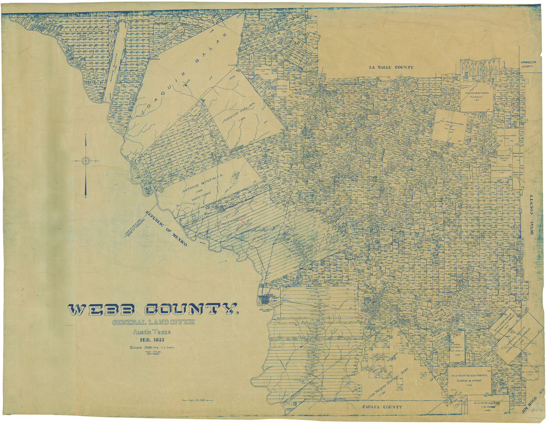
Webb County
-
Map/Doc
82053
-
Collection
General Map Collection
-
Object Dates
2/1933 (Creation Date)
-
People and Organizations
Tom G. Atlee (Draftsman)
-
Counties
Webb
-
Subjects
County
-
Height x Width
45.2 x 58.1 inches
114.8 x 147.6 cm
-
Scale
1" = 3000 varas
-
Comments
Traced April 8, 1933 by Beck.
-
Features
El Peloncillo
Palito Blanco Creek
Serrito Prieto Mountain
Las Pintas Creek
La Tinaja Creek
Saucilio Creek
Llave Creek
Santa Tomos Mountain
Santo Tomas Creek
Connel Barrim Mountain
Branch of Charco Escondido Creek
Carrecitos Creek
El Chacon Creek
Lava
Jacolon Hill
Abra Bonita Creek
Pesgadtto [sic]
Oilton
Rio Grande City Road
Becerra Creek
El Espejo Creek
Alta Callenota
Segura de Pelitas Blancas
Alberca Ravine
Alberca Ranch
La Pitero Creek
Charamusco Creek
Nueces River
El Almud
Los Dos Hermanos
San Lorenzo Creek
Pelito Blanco Creek
Magueyitos Hill
Magueiles Creek
San Cosimiro Creek
Los Olmos Creek
Jaconcinos Creek
San Coritas Creek
Pilotos Creek
La Espada Creek
San Padre Hill
San Pedro Creek
Little Apache Hill
El Vanado Creek
Abra Bonita Creek
Los Cristalos Creek
Cochioo Creek
La Parida Creek
Prieto Creek
Baranquitas Creek
Serrita Chaquita Creek
La Moca Creek
Tineia Escondida Creek
Buena Vista Creek
Rancharitas Creek
La Volanta Creek
Alamito Creek
Salado Creek
El Guisache Creek
Tanguecillas Creek
Carrizitos Creek
Webb
Tordillo Creek
Tejones Creek
Santa Isadal Creek
Zacatosa Creek
Santa Tomos
Cannel Darwin Post Office
Dolores
Charco Ventura Creek
Navajo Creek
Pato Creek
Arroyo del Relacion
Branch of Charco Escondito
Ortas Creek
Caliche Creek
El Pato Creek
Sloan Joyce Station
Rio Grande
Telita Station
Loyerombar
Orvil
Toledo Creek
El Gato Creek
Sada
Sanchez
Davis
Nya
Chacon
Arroyo de San Ignacio
Abra Bonita Creek
Zacate Creek
Laredo
Fort McIntosh
Chacon Creek
Reiser
Arroyo del Guernito
Torrecillas
Arroyo de los Angeles
Bruni
Laurel
Ocnoa
Aguilares
Arroyo Retama
Derromedero del Calvillo
Arroyo Salteador
El Sauz Creek
La Hoya Creek
Las Moritas Creek
San Juanito Creek
La Jarita Creek
Charcodelos Lasos Creek
Arroyo Sarrito Prieto
Nariacitos Creek
Laguna del Javali
Arroyo Bacerrito
La Bitara Creek
Las Blancas Creek
El Soez Creek
Canado de San Antran Creek
El Toro Hill
Cañon de Alberca
Cañon de Miranda
Laguna de Hilario
Laguna de Zocatorros
Part of: General Map Collection

Dallas County Sketch File 15

Print $10.00
- Digital $50.00
Dallas County Sketch File 15
1863
Size 11.5 x 8.5 inches
Map/Doc 20430
Motley County Working Sketch 11

Print $20.00
- Digital $50.00
Motley County Working Sketch 11
1989
Size 28.5 x 33.0 inches
Map/Doc 71216
Flight Mission No. BRE-1P, Frame 127, Nueces County

Print $20.00
- Digital $50.00
Flight Mission No. BRE-1P, Frame 127, Nueces County
1956
Size 18.7 x 22.6 inches
Map/Doc 86693
Brewster County Working Sketch 9

Print $20.00
- Digital $50.00
Brewster County Working Sketch 9
1910
Size 14.3 x 14.4 inches
Map/Doc 67542
[Atlas B, Table of Contents]
![78269, [Atlas B, Table of Contents], General Map Collection](https://historictexasmaps.com/wmedia_w700/maps/78269.tif.jpg)
Print $3.00
- Digital $50.00
[Atlas B, Table of Contents]
Size 10.3 x 9.6 inches
Map/Doc 78269
Map of Duval County

Print $20.00
- Digital $50.00
Map of Duval County
1875
Size 31.0 x 22.2 inches
Map/Doc 3496
Flight Mission No. CRK-8P, Frame 114, Refugio County

Print $20.00
- Digital $50.00
Flight Mission No. CRK-8P, Frame 114, Refugio County
1956
Size 18.3 x 22.1 inches
Map/Doc 86969
Williamson County Sketch File 4

Print $26.00
- Digital $50.00
Williamson County Sketch File 4
1849
Size 15.9 x 10.4 inches
Map/Doc 40304
Hutchinson County Sketch File 23

Print $22.00
- Digital $50.00
Hutchinson County Sketch File 23
1913
Size 11.2 x 8.8 inches
Map/Doc 27245
Real County Working Sketch 15

Print $20.00
- Digital $50.00
Real County Working Sketch 15
1940
Size 17.7 x 22.3 inches
Map/Doc 71907
Crockett County Sketch File 97

Print $20.00
- Digital $50.00
Crockett County Sketch File 97
Size 14.1 x 9.3 inches
Map/Doc 19966
You may also like
Crane County Rolled Sketch 17

Print $20.00
- Digital $50.00
Crane County Rolled Sketch 17
1926
Size 20.3 x 33.8 inches
Map/Doc 5576
Bastrop County Boundary File 2

Print $12.00
- Digital $50.00
Bastrop County Boundary File 2
Size 9.1 x 6.9 inches
Map/Doc 50315
Van Zandt County Sketch File 27

Print $4.00
- Digital $50.00
Van Zandt County Sketch File 27
1859
Size 13.1 x 8.3 inches
Map/Doc 39447
Mills County Boundary File 5

Print $8.00
- Digital $50.00
Mills County Boundary File 5
Size 14.2 x 8.7 inches
Map/Doc 57296
Outer Continental Shelf Leasing Maps (Texas Offshore Operations)

Print $20.00
- Digital $50.00
Outer Continental Shelf Leasing Maps (Texas Offshore Operations)
1954
Size 16.2 x 15.7 inches
Map/Doc 75837
Val Verde County Sketch File 35b

Print $20.00
- Digital $50.00
Val Verde County Sketch File 35b
1936
Size 18.3 x 23.9 inches
Map/Doc 12576
Wise County Sketch File 40

Print $4.00
- Digital $50.00
Wise County Sketch File 40
1875
Size 8.0 x 10.6 inches
Map/Doc 40597
Newton County Rolled Sketch 24
Print $20.00
- Digital $50.00
Newton County Rolled Sketch 24
1893
Size 18.8 x 20.8 inches
Map/Doc 6851
Flight Mission No. BRE-1P, Frame 76, Nueces County

Print $20.00
- Digital $50.00
Flight Mission No. BRE-1P, Frame 76, Nueces County
1956
Size 18.6 x 22.4 inches
Map/Doc 86658
Galveston County NRC Article 33.136 Sketch 67

Print $28.00
- Digital $50.00
Galveston County NRC Article 33.136 Sketch 67
2011
Size 17.0 x 24.0 inches
Map/Doc 93391
Johnson County Working Sketch 30

Print $20.00
- Digital $50.00
Johnson County Working Sketch 30
2007
Size 40.9 x 42.0 inches
Map/Doc 83807
Fisher County Working Sketch 8

Print $20.00
- Digital $50.00
Fisher County Working Sketch 8
1946
Size 42.5 x 37.3 inches
Map/Doc 69142