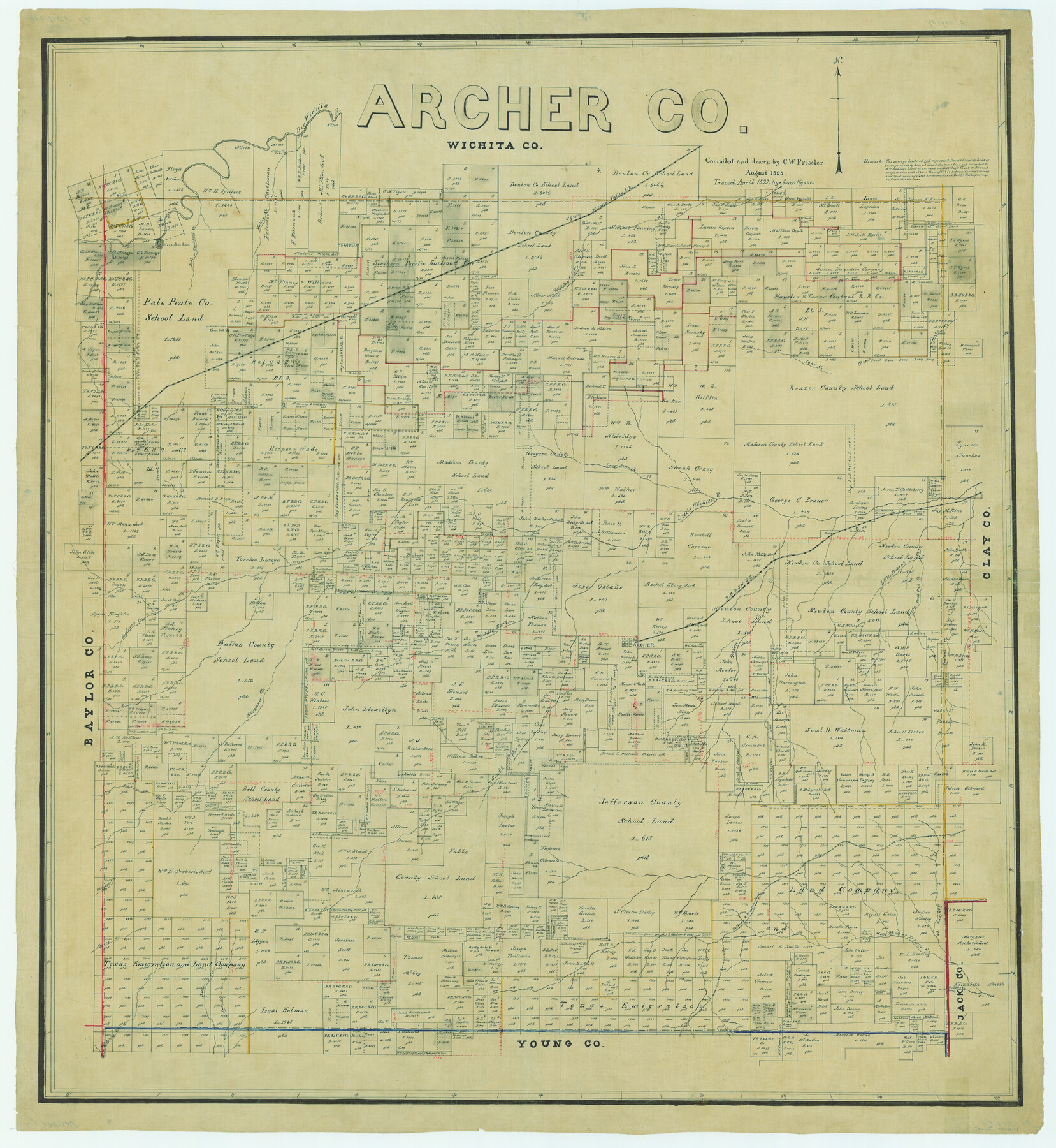
Archer Co.
-
Map/Doc
78321
-
Collection
General Map Collection
-
Object Dates
1898 (Creation Date)
-
People and Organizations
Texas General Land Office (Publisher)
Chas. W. Pressler (Draftsman)
Chas. W. Pressler (Compiler)
-
Counties
Archer
-
Subjects
County
-
Height x Width
40.0 x 36.8 inches
101.6 x 93.5 cm
-
Comments
Traced in April 1899 by Amos Wynne.
Part of: General Map Collection
Reagan County Sketch File 19

Print $26.00
- Digital $50.00
Reagan County Sketch File 19
1937
Size 14.0 x 28.7 inches
Map/Doc 12220
Val Verde County Sketch File XXX5

Print $40.00
- Digital $50.00
Val Verde County Sketch File XXX5
Size 13.2 x 13.4 inches
Map/Doc 39100
Val Verde County Working Sketch Graphic Index, Sheet 2 (Sketches 26 to 88)

Print $20.00
- Digital $50.00
Val Verde County Working Sketch Graphic Index, Sheet 2 (Sketches 26 to 88)
1944
Size 40.3 x 36.4 inches
Map/Doc 76725
Hutchinson County Sketch File 38

Print $40.00
- Digital $50.00
Hutchinson County Sketch File 38
1935
Size 17.6 x 14.2 inches
Map/Doc 27280
Flight Mission No. BQR-5K, Frame 69, Brazoria County

Print $20.00
- Digital $50.00
Flight Mission No. BQR-5K, Frame 69, Brazoria County
1952
Size 18.8 x 22.4 inches
Map/Doc 84014
Crockett County Rolled Sketch 88H

Print $40.00
- Digital $50.00
Crockett County Rolled Sketch 88H
1973
Size 42.6 x 57.3 inches
Map/Doc 8733
Louisiana and Texas Intracoastal Waterway

Print $20.00
- Digital $50.00
Louisiana and Texas Intracoastal Waterway
1929
Size 13.8 x 19.7 inches
Map/Doc 83340
Houston County Working Sketch 18

Print $20.00
- Digital $50.00
Houston County Working Sketch 18
Size 18.8 x 22.5 inches
Map/Doc 66248
Flight Mission No. DIX-10P, Frame 71, Aransas County

Print $20.00
- Digital $50.00
Flight Mission No. DIX-10P, Frame 71, Aransas County
1956
Size 18.6 x 22.3 inches
Map/Doc 83932
Wichita County

Print $20.00
- Digital $50.00
Wichita County
1889
Size 26.8 x 37.4 inches
Map/Doc 4144
Liberty County Rolled Sketch 13

Print $20.00
- Digital $50.00
Liberty County Rolled Sketch 13
1983
Size 27.0 x 37.8 inches
Map/Doc 6619
Burnet County Sketch File 24

Print $8.00
- Digital $50.00
Burnet County Sketch File 24
1872
Size 7.9 x 10.2 inches
Map/Doc 16721
You may also like
Map of the State of Texas Showing Original Land Districts

Print $20.00
- Digital $50.00
Map of the State of Texas Showing Original Land Districts
1891
Size 45.6 x 43.0 inches
Map/Doc 1995
Right of Way & Track Map San Antonio & Aransas Pass Railway Co.

Print $40.00
- Digital $50.00
Right of Way & Track Map San Antonio & Aransas Pass Railway Co.
1919
Size 25.1 x 56.7 inches
Map/Doc 64026
Maps of Gulf Intracoastal Waterway, Texas - Sabine River to the Rio Grande and connecting waterways including ship channels

Print $20.00
- Digital $50.00
Maps of Gulf Intracoastal Waterway, Texas - Sabine River to the Rio Grande and connecting waterways including ship channels
1966
Size 14.5 x 22.2 inches
Map/Doc 61920
Travis County Working Sketch 32

Print $20.00
- Digital $50.00
Travis County Working Sketch 32
1965
Size 28.0 x 40.0 inches
Map/Doc 69416
Andrews County Working Sketch 21

Print $40.00
- Digital $50.00
Andrews County Working Sketch 21
1979
Size 38.7 x 48.4 inches
Map/Doc 67067
Comanche County Working Sketch 26

Print $20.00
- Digital $50.00
Comanche County Working Sketch 26
1981
Size 26.0 x 32.4 inches
Map/Doc 68160
Mason County Rolled Sketch 2

Print $20.00
- Digital $50.00
Mason County Rolled Sketch 2
1952
Size 32.9 x 26.7 inches
Map/Doc 6675
Polk County Rolled Sketch 29

Print $86.00
- Digital $50.00
Polk County Rolled Sketch 29
1954
Size 9.3 x 14.9 inches
Map/Doc 48066
Liberty County Working Sketch 23

Print $20.00
- Digital $50.00
Liberty County Working Sketch 23
1941
Size 29.9 x 26.4 inches
Map/Doc 70482
Flight Mission No. DCL-6C, Frame 96, Kenedy County

Print $20.00
- Digital $50.00
Flight Mission No. DCL-6C, Frame 96, Kenedy County
1943
Size 18.6 x 22.4 inches
Map/Doc 85926
[Fisher County School Land Lgs. 106-108]
![90198, [Fisher County School Land Lgs. 106-108], Twichell Survey Records](https://historictexasmaps.com/wmedia_w700/maps/90198-1.tif.jpg)
Print $20.00
- Digital $50.00
[Fisher County School Land Lgs. 106-108]
Size 11.7 x 18.4 inches
Map/Doc 90198
[T. & P. Block 44, Township 1S]
![90825, [T. & P. Block 44, Township 1S], Twichell Survey Records](https://historictexasmaps.com/wmedia_w700/maps/90825-2.tif.jpg)
Print $20.00
- Digital $50.00
[T. & P. Block 44, Township 1S]
Size 17.9 x 23.3 inches
Map/Doc 90825