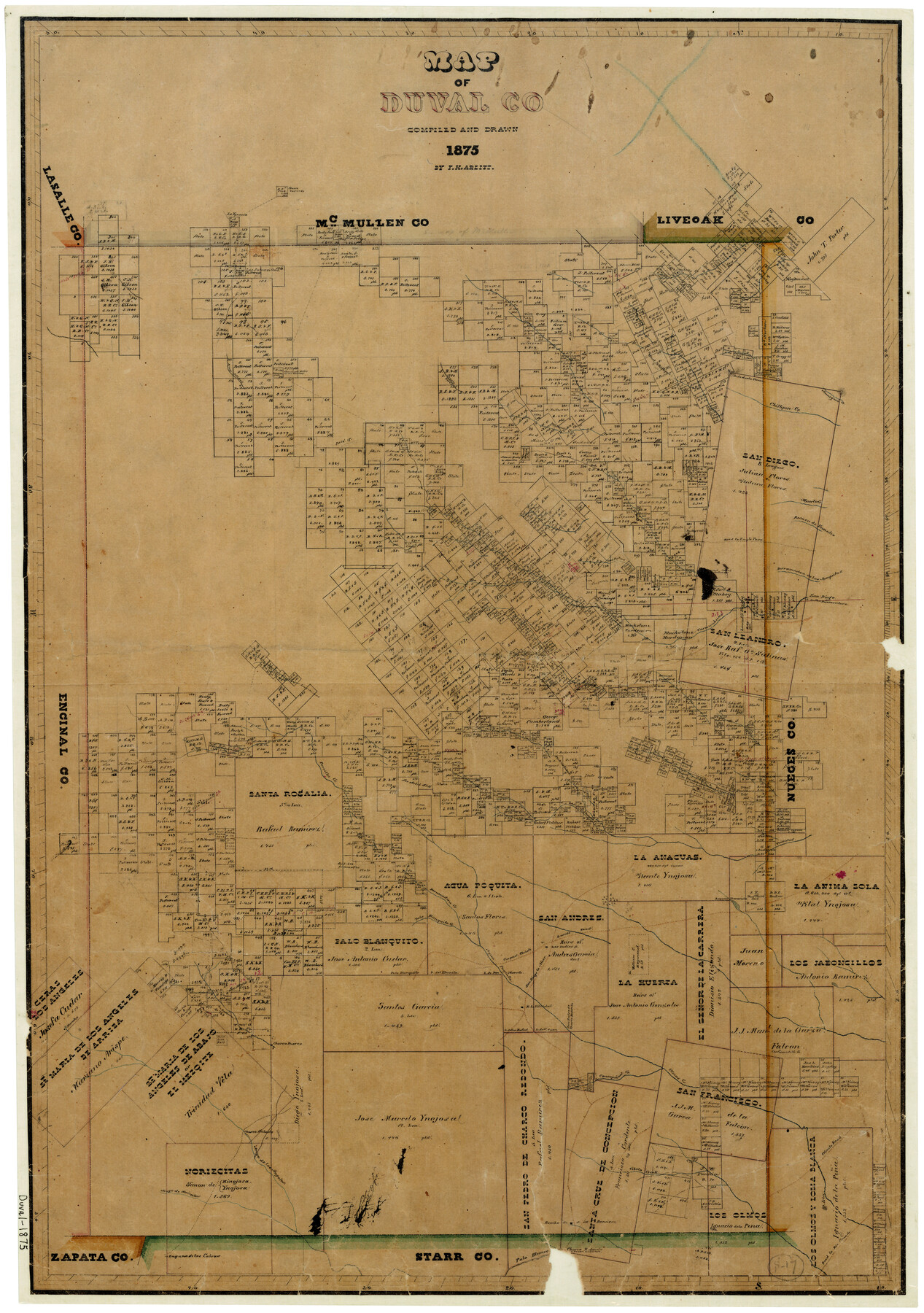
Map of Duval County
-
Map/Doc
3496
-
Collection
General Map Collection
-
Object Dates
1875 (Creation Date)
-
People and Organizations
Texas General Land Office (Publisher)
F.H. Arlitt (Draftsman)
F.H. Arlitt (Compiler)
-
Counties
Duval
-
Subjects
County
-
Height x Width
31.0 x 22.2 inches
78.7 x 56.4 cm
-
Features
Road to Rio Grande
Olmito Road
San Diego to Mier Road
San Diego Road
Mier Road
Olmos Creek
Concepcion Creek
Cibolo Creek
Aroyo [sic] de Los Angeles
Aroyo [sic] de Noriecitas
Laguna de Las Cabras
Palo Blanco Creek
Rancho de J. M. Ramirez
Laredo Road
Charco Valiente Lake
Botello Creek
L. de Santa Teresa Hill
Resaca de Eumedio Creek
Derramudera [sic] de las Anaquitas Creek
L. de San Buenaventura
Los Indios Rancho
Rancho La Felicidal
La Baronesta Creek
Charco Puerco Lake
Charco Salado Lake
Charco Redondo Lake
Road to Eagle Pass
Arroyo Solidad
Rotello Creek
Amargosa Creek
Chiltipin Creek
West Chiltipin Creek
Collins Creek
Tenaja Piedra Creek
San Juan Creek
Las Pritas Creek
San Diego Creek
San Diego
Muerto Creek
La Ygnacia Creek
Tarancahuas Creek
Narcisena Creek
Las Animas Creek
Laguna Travesada
Parrilla Creek
Piedra Pintas Creek
Trinidad Creek
Deramadera Creek
Palo Blanquito Creek
Aqua Paquita Creek
Corpus Christi to Laredo Road
Corpus Christi Road
Part of: General Map Collection
Brewster County Rolled Sketch 17

Print $40.00
- Digital $50.00
Brewster County Rolled Sketch 17
Size 25.1 x 63.4 inches
Map/Doc 5195
Flight Mission No. BQY-1T, Frame 74, Harris County

Print $20.00
- Digital $50.00
Flight Mission No. BQY-1T, Frame 74, Harris County
1957
Size 17.5 x 17.6 inches
Map/Doc 85294
Donley County Sketch File 21

Print $4.00
- Digital $50.00
Donley County Sketch File 21
Size 8.4 x 9.5 inches
Map/Doc 21256

Wichita County Working Sketch 23

Print $5.00
- Digital $50.00
Wichita County Working Sketch 23
Size 28.4 x 30.8 inches
Map/Doc 72533
Jim Hogg County Sketch File 8

Print $20.00
- Digital $50.00
Jim Hogg County Sketch File 8
1941
Size 21.9 x 27.0 inches
Map/Doc 11887
McMullen County Working Sketch 57

Print $4.00
- Digital $50.00
McMullen County Working Sketch 57
1983
Size 29.5 x 18.8 inches
Map/Doc 70758
Coryell County Working Sketch 6

Print $20.00
- Digital $50.00
Coryell County Working Sketch 6
1941
Size 15.9 x 13.6 inches
Map/Doc 68213
Refugio County Working Sketch 11

Print $20.00
- Digital $50.00
Refugio County Working Sketch 11
Size 40.9 x 38.3 inches
Map/Doc 63520
Schleicher County Working Sketch 18

Print $20.00
- Digital $50.00
Schleicher County Working Sketch 18
Size 28.4 x 22.1 inches
Map/Doc 63820
Galveston County NRC Article 33.136 Sketch 77

Print $44.00
- Digital $50.00
Galveston County NRC Article 33.136 Sketch 77
2015
Size 24.0 x 36.0 inches
Map/Doc 94991
Gaines County Sketch File 17

Print $32.00
- Digital $50.00
Gaines County Sketch File 17
1962
Size 11.3 x 8.8 inches
Map/Doc 23204
You may also like
Jeff Davis County Rolled Sketch 11

Print $20.00
- Digital $50.00
Jeff Davis County Rolled Sketch 11
1914
Size 17.9 x 14.4 inches
Map/Doc 6364
Hudspeth County Rolled Sketch 14
Print $20.00
- Digital $50.00
Hudspeth County Rolled Sketch 14
1885
Size 36.0 x 17.0 inches
Map/Doc 9202
Galveston County NRC Article 33.136 Sketch 55A

Print $28.00
- Digital $50.00
Galveston County NRC Article 33.136 Sketch 55A
2009
Size 24.0 x 36.0 inches
Map/Doc 94616
Reagan County Sketch File 3

Print $20.00
- Digital $50.00
Reagan County Sketch File 3
Size 18.0 x 21.9 inches
Map/Doc 12213
Famous Heights Park Addition, Map Showing Proposed Park and Plan of Subdividing Famous Heights Plus Park, Addition to the city of Amarillo, Texas

Print $40.00
- Digital $50.00
Famous Heights Park Addition, Map Showing Proposed Park and Plan of Subdividing Famous Heights Plus Park, Addition to the city of Amarillo, Texas
1907
Size 62.5 x 37.4 inches
Map/Doc 93117
[Sketch showing County School Land Leagues]
![90101, [Sketch showing County School Land Leagues], Twichell Survey Records](https://historictexasmaps.com/wmedia_w700/maps/90101-1.tif.jpg)
Print $3.00
- Digital $50.00
[Sketch showing County School Land Leagues]
1902
Size 11.0 x 11.1 inches
Map/Doc 90101
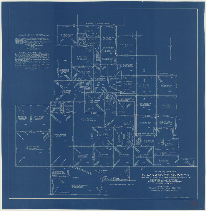
Clay County Working Sketch 11
Print $20.00
- Digital $50.00
Clay County Working Sketch 11
1941
Size 27.7 x 27.1 inches
Map/Doc 68034
Starr County Sketch File 9

Print $22.00
- Digital $50.00
Starr County Sketch File 9
Size 9.1 x 7.9 inches
Map/Doc 36861
Nueces County Sketch File 38

Print $16.00
- Digital $50.00
Nueces County Sketch File 38
1931
Size 8.7 x 11.2 inches
Map/Doc 32615
Culberson County Sketch File 31

Print $4.00
- Digital $50.00
Culberson County Sketch File 31
1951
Size 11.3 x 8.9 inches
Map/Doc 20283
Shackelford County Rolled Sketch 4

Print $20.00
- Digital $50.00
Shackelford County Rolled Sketch 4
Size 38.8 x 47.7 inches
Map/Doc 9916
Archer County Working Sketch 7

Print $20.00
- Digital $50.00
Archer County Working Sketch 7
1921
Size 32.6 x 24.9 inches
Map/Doc 67147