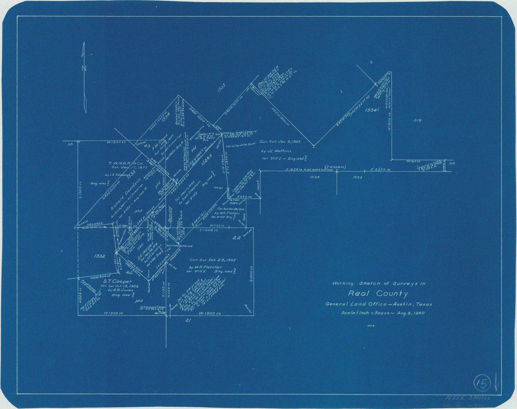
Real County Working Sketch 15
-
Map/Doc
71907
-
Collection
General Map Collection
-
Object Dates
8/8/1940 (Creation Date)
-
People and Organizations
W. S. Brewington (Draftsman)
-
Counties
Real
-
Subjects
Surveying Working Sketch
-
Height x Width
17.7 x 22.3 inches
45.0 x 56.6 cm
-
Scale
1" = 500 varas
Part of: General Map Collection
Panola County Working Sketch 12

Print $20.00
- Digital $50.00
Panola County Working Sketch 12
1945
Map/Doc 71421
Map of The Surveyed Part of Peters Colony Texas

Print $40.00
- Digital $50.00
Map of The Surveyed Part of Peters Colony Texas
1852
Size 56.5 x 41.0 inches
Map/Doc 1966
Flight Mission No. DQN-2K, Frame 37, Calhoun County

Print $20.00
- Digital $50.00
Flight Mission No. DQN-2K, Frame 37, Calhoun County
1953
Size 18.4 x 22.2 inches
Map/Doc 84242
Hardin County Working Sketch 21

Print $20.00
- Digital $50.00
Hardin County Working Sketch 21
1947
Size 43.2 x 38.4 inches
Map/Doc 63419
Flight Mission No. CON-2R, Frame 173, Stonewall County

Print $20.00
- Digital $50.00
Flight Mission No. CON-2R, Frame 173, Stonewall County
1957
Size 18.3 x 22.1 inches
Map/Doc 86991
Harris County Working Sketch 63

Print $20.00
- Digital $50.00
Harris County Working Sketch 63
1954
Size 34.0 x 36.8 inches
Map/Doc 65955
La Salle County Sketch File 47

Print $8.00
- Digital $50.00
La Salle County Sketch File 47
1941
Size 14.2 x 8.9 inches
Map/Doc 29613
Flight Mission No. DAG-21K, Frame 103, Matagorda County

Print $20.00
- Digital $50.00
Flight Mission No. DAG-21K, Frame 103, Matagorda County
1952
Size 18.7 x 22.3 inches
Map/Doc 86431
Flight Mission No. DAG-24K, Frame 39, Matagorda County

Print $20.00
- Digital $50.00
Flight Mission No. DAG-24K, Frame 39, Matagorda County
1953
Size 18.5 x 22.3 inches
Map/Doc 86526
Callahan County Sketch File 11

Print $64.00
- Digital $50.00
Callahan County Sketch File 11
Size 11.4 x 8.4 inches
Map/Doc 35887
Calhoun County NRC Article 33.136 Location Key Sheet

Print $20.00
- Digital $50.00
Calhoun County NRC Article 33.136 Location Key Sheet
1973
Size 27.0 x 22.0 inches
Map/Doc 77010
Lavaca County Working Sketch 9

Print $20.00
- Digital $50.00
Lavaca County Working Sketch 9
1949
Size 24.7 x 33.9 inches
Map/Doc 70362
You may also like
Crockett County Rolled Sketch 81

Print $20.00
- Digital $50.00
Crockett County Rolled Sketch 81
1958
Size 20.6 x 24.5 inches
Map/Doc 5621
![90513, [Capitol Lands], Twichell Survey Records](https://historictexasmaps.com/wmedia_w700/maps/90513-1.tif.jpg)
From Citizens of Liberty County for the Creation a New County to be Called Crockett, November 12, 1838

Print $20.00
From Citizens of Liberty County for the Creation a New County to be Called Crockett, November 12, 1838
2020
Size 22.3 x 21.7 inches
Map/Doc 96385
San Saba County Sketch File 16

Print $20.00
- Digital $50.00
San Saba County Sketch File 16
1902
Size 16.9 x 18.8 inches
Map/Doc 12294
Dry Fork of Brushy Creek

Print $2.00
- Digital $50.00
Dry Fork of Brushy Creek
Size 7.1 x 6.8 inches
Map/Doc 78380
Little River, Buckholts Sheet

Print $4.00
- Digital $50.00
Little River, Buckholts Sheet
1936
Size 30.0 x 24.2 inches
Map/Doc 65065
Nueces County Rolled Sketch 25

Print $40.00
- Digital $50.00
Nueces County Rolled Sketch 25
1940
Size 32.2 x 48.4 inches
Map/Doc 9594
Plan C, Part 1st Shewing that portion of the boundary between Texas and the United States, included between the intersection of the 32nd degree of Latitude with western bank of Sabine River and the 36th mile mound

Print $20.00
- Digital $50.00
Plan C, Part 1st Shewing that portion of the boundary between Texas and the United States, included between the intersection of the 32nd degree of Latitude with western bank of Sabine River and the 36th mile mound
1842
Size 19.4 x 27.7 inches
Map/Doc 65412
Gaines County Working Sketch 32

Print $20.00
- Digital $50.00
Gaines County Working Sketch 32
1990
Size 38.3 x 26.3 inches
Map/Doc 69332
Nueces County Rolled Sketch 95

Print $20.00
- Digital $50.00
Nueces County Rolled Sketch 95
1983
Size 18.2 x 24.7 inches
Map/Doc 7052
La Salle County Sketch File 16

Print $5.00
- Digital $50.00
La Salle County Sketch File 16
1883
Size 9.3 x 9.7 inches
Map/Doc 29487
Map of Comanche County
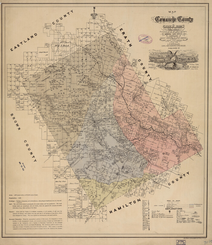
Print $20.00
Map of Comanche County
1876
Size 28.0 x 24.1 inches
Map/Doc 88919