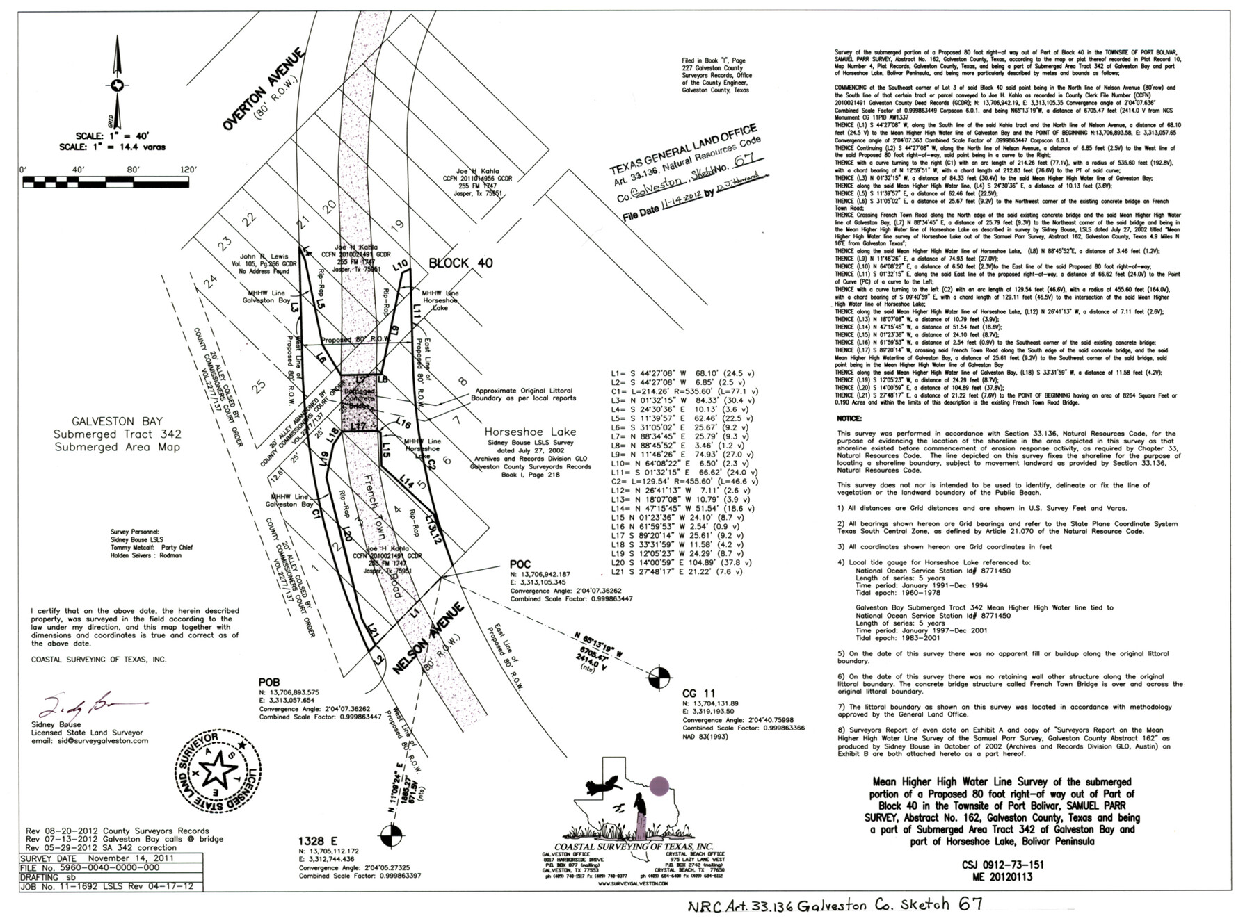
Galveston County NRC Article 33.136 Sketch 67
French Town Bridge - Bolivar Peninsula - MHHW at confluence of Galveston Bay and Horseshoe Lake
-
Map/Doc
93391
-
Collection
General Map Collection
-
Object Dates
2011/11/14 (Creation Date)
2012/11/14 (File Date)
-
People and Organizations
Sidney Bouse (Draftsman)
Sidney Bouse (Surveyor/Engineer)
-
Counties
Galveston
-
Subjects
Surveying CBS
-
Height x Width
17.0 x 24.0 inches
43.2 x 61.0 cm
-
Medium
multi-page, multi-format
-
Comments
ME 20120113
Part of: General Map Collection
Hardeman County Working Sketch 1

Print $20.00
- Digital $50.00
Hardeman County Working Sketch 1
Size 16.3 x 21.3 inches
Map/Doc 63382
Starr County Rolled Sketch 24

Print $20.00
- Digital $50.00
Starr County Rolled Sketch 24
1938
Size 37.5 x 26.7 inches
Map/Doc 7808
Robertson County Sketch File 10 (1)

Print $3.00
- Digital $50.00
Robertson County Sketch File 10 (1)
Size 13.0 x 10.4 inches
Map/Doc 43369
Wichita County Sketch File 9a

Print $4.00
- Digital $50.00
Wichita County Sketch File 9a
Size 10.7 x 8.2 inches
Map/Doc 40052
Donley County Boundary File 7

Print $31.00
- Digital $50.00
Donley County Boundary File 7
Size 11.3 x 8.6 inches
Map/Doc 52640
Angelina County Working Sketch Graphic Index

Print $40.00
- Digital $50.00
Angelina County Working Sketch Graphic Index
1945
Size 37.4 x 48.3 inches
Map/Doc 76454
Harris County Sketch File 43

Print $6.00
- Digital $50.00
Harris County Sketch File 43
1905
Size 11.1 x 8.7 inches
Map/Doc 25440
Fisher County Rolled Sketch 4

Print $20.00
- Digital $50.00
Fisher County Rolled Sketch 4
Size 32.4 x 37.5 inches
Map/Doc 8888
Crockett County Rolled Sketch 30

Print $20.00
- Digital $50.00
Crockett County Rolled Sketch 30
1934
Size 24.5 x 43.1 inches
Map/Doc 8700
El Paso County Working Sketch 14

Print $20.00
- Digital $50.00
El Paso County Working Sketch 14
1957
Size 10.0 x 27.0 inches
Map/Doc 69036
Brazoria County Sketch File 11

Print $4.00
- Digital $50.00
Brazoria County Sketch File 11
Size 10.5 x 8.5 inches
Map/Doc 14965
Reagan County Working Sketch 39

Print $20.00
- Digital $50.00
Reagan County Working Sketch 39
1971
Size 22.5 x 36.1 inches
Map/Doc 71881
You may also like
Red River, Bois D'Arc Creek Floodway Sheet No. 2

Print $20.00
- Digital $50.00
Red River, Bois D'Arc Creek Floodway Sheet No. 2
1917
Size 20.4 x 29.9 inches
Map/Doc 69657
[Texas & Pacific Railway, Longview to Dallas]
![64098, [Texas & Pacific Railway, Longview to Dallas], General Map Collection](https://historictexasmaps.com/wmedia_w700/maps/64098.tif.jpg)
Print $40.00
- Digital $50.00
[Texas & Pacific Railway, Longview to Dallas]
1873
Size 14.5 x 121.6 inches
Map/Doc 64098
Zapata County Working Sketch 16

Print $20.00
- Digital $50.00
Zapata County Working Sketch 16
1969
Size 26.1 x 28.3 inches
Map/Doc 62067
Polk County Sketch File 14

Print $6.00
- Digital $50.00
Polk County Sketch File 14
Size 5.7 x 11.4 inches
Map/Doc 34152
Hemphill County Working Sketch 4

Print $20.00
- Digital $50.00
Hemphill County Working Sketch 4
1940
Size 31.6 x 41.6 inches
Map/Doc 66099
Map of Roberts County

Print $20.00
- Digital $50.00
Map of Roberts County
1932
Size 42.9 x 39.0 inches
Map/Doc 95626
Goliad County Sketch File 31

Print $6.00
- Digital $50.00
Goliad County Sketch File 31
1897
Size 10.7 x 8.2 inches
Map/Doc 24329
Garza County Sketch File G-1

Print $20.00
- Digital $50.00
Garza County Sketch File G-1
1904
Size 20.4 x 20.6 inches
Map/Doc 11554
Hopkins County Working Sketch Graphic Index

Print $20.00
- Digital $50.00
Hopkins County Working Sketch Graphic Index
1942
Size 40.6 x 38.7 inches
Map/Doc 76581
Township No. 2 South Range No. 19 West of the Indian Meridian

Print $20.00
- Digital $50.00
Township No. 2 South Range No. 19 West of the Indian Meridian
1875
Size 19.2 x 24.8 inches
Map/Doc 75181
Henderson County Working Sketch 44

Print $20.00
- Digital $50.00
Henderson County Working Sketch 44
1998
Size 19.0 x 33.0 inches
Map/Doc 66177
Lipscomb County Boundary File 12

Print $4.00
- Digital $50.00
Lipscomb County Boundary File 12
Size 10.6 x 8.1 inches
Map/Doc 56351