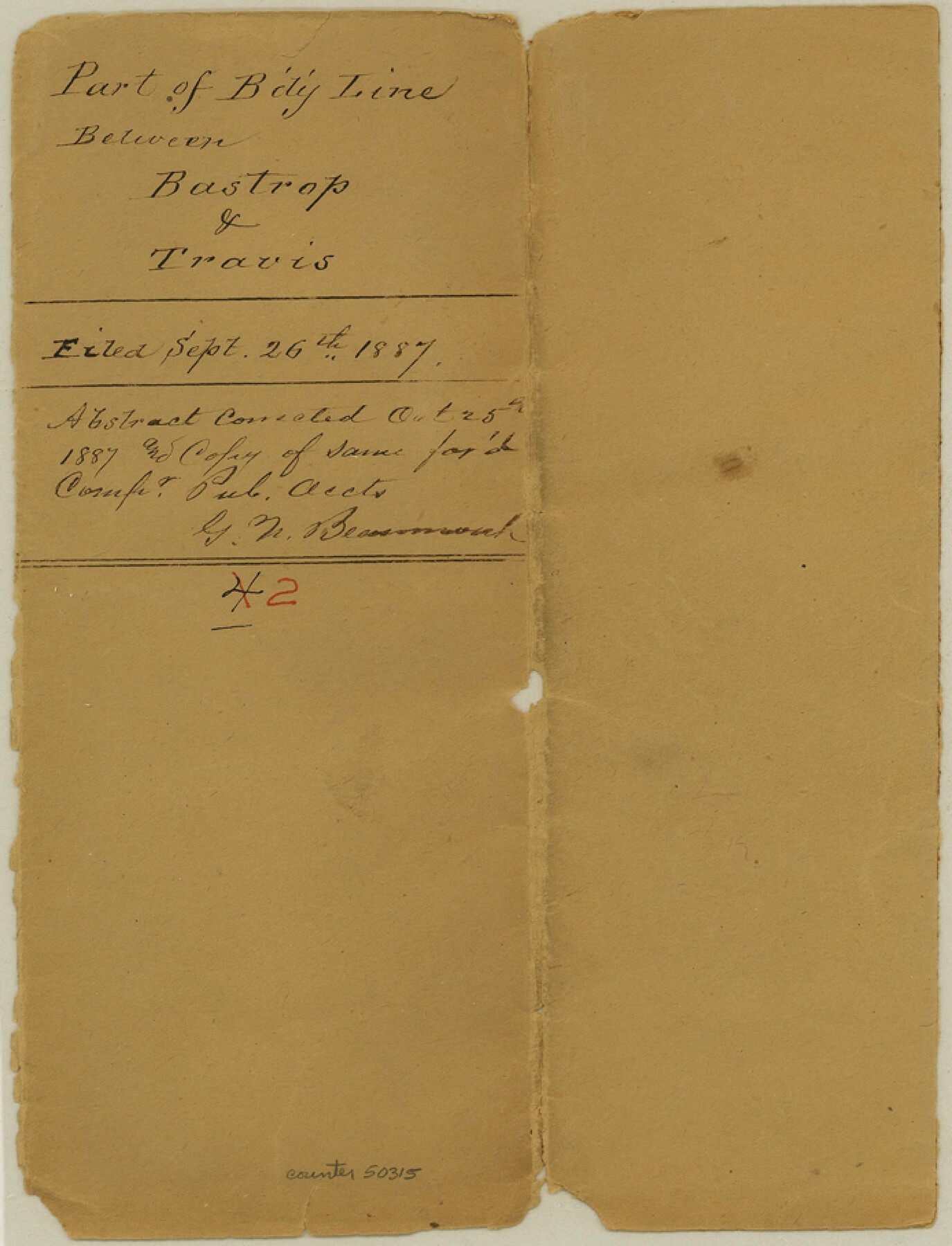
Bastrop County Boundary File 2
County line between Bastrop and Travis beginning at the Colorado River and running to the N. W. Cor. Bastrop Co.
-
Map/Doc
50315
-
Collection
General Map Collection
-
Counties
Bastrop
-
Subjects
County Boundaries
-
Height x Width
9.1 x 6.9 inches
23.1 x 17.5 cm
Part of: General Map Collection
PSL Field Notes for Blocks B14 and B16 in Crane and Ector Counties, Blocks B18 and B20 in Crane and Ward Counties, and Blocks B17, B21, B22, B23, B24, B25, and B26 in Crane County

PSL Field Notes for Blocks B14 and B16 in Crane and Ector Counties, Blocks B18 and B20 in Crane and Ward Counties, and Blocks B17, B21, B22, B23, B24, B25, and B26 in Crane County
Map/Doc 81646
Reagan County Working Sketch 21

Print $20.00
- Digital $50.00
Reagan County Working Sketch 21
1955
Size 23.4 x 19.9 inches
Map/Doc 71863
Coryell County Sketch File 13

Print $4.00
- Digital $50.00
Coryell County Sketch File 13
1872
Size 5.0 x 8.5 inches
Map/Doc 19366
Texas-Oklahoma, Red River, Big Bend Area

Print $40.00
- Digital $50.00
Texas-Oklahoma, Red River, Big Bend Area
1921
Size 23.3 x 57.6 inches
Map/Doc 75251
Refugio County

Print $20.00
- Digital $50.00
Refugio County
1872
Size 17.6 x 22.9 inches
Map/Doc 3987
Edwards County Working Sketch 21

Print $20.00
- Digital $50.00
Edwards County Working Sketch 21
1935
Size 26.7 x 32.0 inches
Map/Doc 68897
Flight Mission No. BRA-7M, Frame 79, Jefferson County

Print $20.00
- Digital $50.00
Flight Mission No. BRA-7M, Frame 79, Jefferson County
1953
Size 16.0 x 15.8 inches
Map/Doc 85501
Sterling County Sketch File 8

Print $20.00
- Digital $50.00
Sterling County Sketch File 8
1916
Size 27.2 x 25.2 inches
Map/Doc 12357
Hudspeth County Sketch File 43

Print $10.00
- Digital $50.00
Hudspeth County Sketch File 43
1982
Size 14.3 x 8.9 inches
Map/Doc 27022

Lavaca County Rolled Sketch 8

Print $40.00
- Digital $50.00
Lavaca County Rolled Sketch 8
1982
Size 36.5 x 65.6 inches
Map/Doc 10289
Williamson County Sketch File 15

Print $4.00
- Digital $50.00
Williamson County Sketch File 15
Size 10.0 x 8.0 inches
Map/Doc 40334
You may also like
Harris County NRC Article 33.136 Sketch 6

Print $21.00
- Digital $50.00
Harris County NRC Article 33.136 Sketch 6
2003
Size 23.1 x 34.8 inches
Map/Doc 78664

Maps of Gulf Intracoastal Waterway, Texas - Sabine River to the Rio Grande and connecting waterways including ship channels

Print $20.00
- Digital $50.00
Maps of Gulf Intracoastal Waterway, Texas - Sabine River to the Rio Grande and connecting waterways including ship channels
1966
Size 15.7 x 22.0 inches
Map/Doc 61983
[Dennis Corwin's Map of Survey for R. N. Graham]
![75781, [Dennis Corwin's Map of Survey for R. N. Graham], Maddox Collection](https://historictexasmaps.com/wmedia_w700/maps/75781-1.tif.jpg)
Print $2.00
- Digital $50.00
[Dennis Corwin's Map of Survey for R. N. Graham]
Size 11.1 x 8.4 inches
Map/Doc 75781
Map of the Western Territory &c.

Print $20.00
- Digital $50.00
Map of the Western Territory &c.
1834
Size 18.5 x 18.8 inches
Map/Doc 95691
Galveston County Working Sketch 9

Print $20.00
- Digital $50.00
Galveston County Working Sketch 9
1948
Size 31.9 x 25.8 inches
Map/Doc 69346
Brewster County Rolled Sketch 22B

Print $20.00
- Digital $50.00
Brewster County Rolled Sketch 22B
1910
Size 24.5 x 19.5 inches
Map/Doc 5203
Jefferson County Rolled Sketch 39

Print $20.00
- Digital $50.00
Jefferson County Rolled Sketch 39
1885
Size 31.6 x 34.3 inches
Map/Doc 9300
Map of Matagorda Bay and County with the Adjacent Country

Print $20.00
- Digital $50.00
Map of Matagorda Bay and County with the Adjacent Country
1839
Size 33.4 x 42.6 inches
Map/Doc 2002
Presidio County Working Sketch 11

Print $20.00
- Digital $50.00
Presidio County Working Sketch 11
1941
Size 29.2 x 25.8 inches
Map/Doc 71686
Cochran and Yoakum Counties, Texas

Print $20.00
- Digital $50.00
Cochran and Yoakum Counties, Texas
1945
Size 24.4 x 17.4 inches
Map/Doc 92513
Flight Mission No. CRC-3R, Frame 208, Chambers County

Print $20.00
- Digital $50.00
Flight Mission No. CRC-3R, Frame 208, Chambers County
1956
Size 18.6 x 22.3 inches
Map/Doc 84863