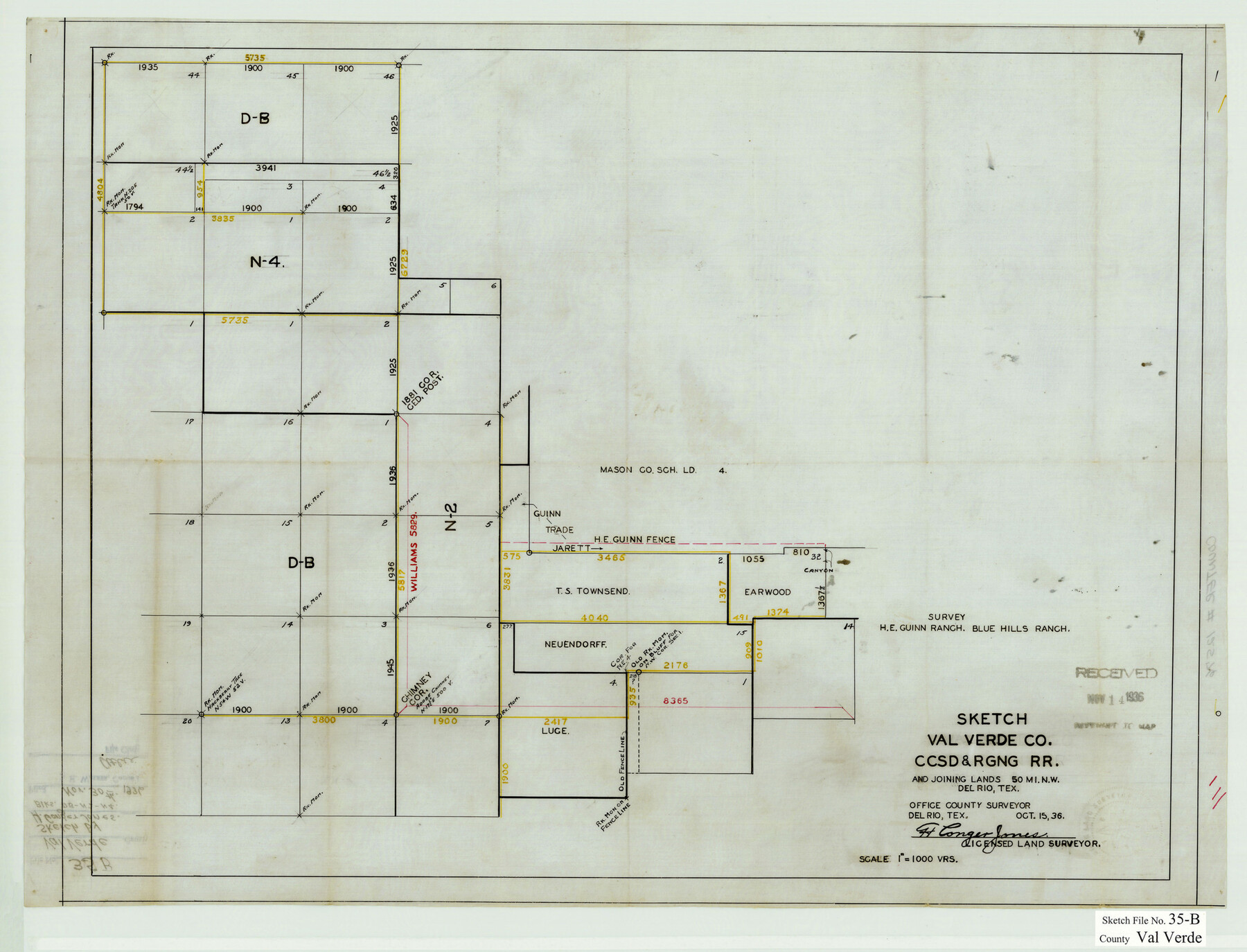
Val Verde County Sketch File 35b
[Sketch of surveys in Blocks DB, N4, and N2 northwest from Del Rio]
-
Map/Doc
12576
-
Collection
General Map Collection
-
Object Dates
10/15/1936 (Creation Date)
11/30/1936 (File Date)
-
People and Organizations
H. Conger Jones (Surveyor/Engineer)
-
Counties
Val Verde
-
Subjects
Surveying Sketch File
-
Height x Width
18.3 x 23.9 inches
46.5 x 60.7 cm
-
Medium
mylar, print
Part of: General Map Collection
Pecos County Rolled Sketch 101

Print $20.00
- Digital $50.00
Pecos County Rolled Sketch 101
1938
Size 22.5 x 39.0 inches
Map/Doc 7249
Flight Mission No. CUG-1P, Frame 112, Kleberg County

Print $20.00
- Digital $50.00
Flight Mission No. CUG-1P, Frame 112, Kleberg County
1956
Size 18.5 x 22.3 inches
Map/Doc 86162
Controlled Mosaic by Jack Amman Photogrammetric Engineers, Inc - Sheet 42

Print $20.00
- Digital $50.00
Controlled Mosaic by Jack Amman Photogrammetric Engineers, Inc - Sheet 42
1954
Size 20.0 x 24.0 inches
Map/Doc 83500
Map of Corpus Christi Bay in Nueces County Showing Subdivision for Mineral Development

Print $40.00
- Digital $50.00
Map of Corpus Christi Bay in Nueces County Showing Subdivision for Mineral Development
1950
Size 49.3 x 37.2 inches
Map/Doc 3129
Comal County Sketch File 7

Print $4.00
- Digital $50.00
Comal County Sketch File 7
Size 13.5 x 8.3 inches
Map/Doc 19011
Flight Mission No. DCL-7C, Frame 10, Kenedy County

Print $20.00
- Digital $50.00
Flight Mission No. DCL-7C, Frame 10, Kenedy County
1943
Size 15.3 x 15.2 inches
Map/Doc 86002
Motley County Sketch File 11 (N)

Print $14.00
- Digital $50.00
Motley County Sketch File 11 (N)
1900
Size 11.1 x 8.6 inches
Map/Doc 32036
[Map of Nueces Bay Showing Old Leases]
![2924, [Map of Nueces Bay Showing Old Leases], General Map Collection](https://historictexasmaps.com/wmedia_w700/maps/2924-1.tif.jpg)
Print $20.00
- Digital $50.00
[Map of Nueces Bay Showing Old Leases]
1936
Size 18.0 x 22.9 inches
Map/Doc 2924
Harris County Sketch File 69b

Print $20.00
- Digital $50.00
Harris County Sketch File 69b
1938
Size 25.3 x 18.9 inches
Map/Doc 11664
Current Miscellaneous File 94

Print $3.00
- Digital $50.00
Current Miscellaneous File 94
1851
Size 11.2 x 17.1 inches
Map/Doc 74268
Brazoria County Working Sketch 3

Print $20.00
- Digital $50.00
Brazoria County Working Sketch 3
1915
Size 13.0 x 11.1 inches
Map/Doc 67488
Deaf Smith County

Print $40.00
- Digital $50.00
Deaf Smith County
1926
Size 38.5 x 50.3 inches
Map/Doc 95477
You may also like
San Augustine County

Print $20.00
- Digital $50.00
San Augustine County
1871
Size 20.7 x 14.2 inches
Map/Doc 4014
Map of Cameron, Hidalgo and half of Starr County of Texas

Print $20.00
- Digital $50.00
Map of Cameron, Hidalgo and half of Starr County of Texas
1900
Size 42.4 x 30.3 inches
Map/Doc 3150
Montgomery County Sketch File 19

Print $24.00
- Digital $50.00
Montgomery County Sketch File 19
1931
Size 9.0 x 7.0 inches
Map/Doc 31835
Controlled Mosaic by Jack Amman Photogrammetric Engineers, Inc - Sheet 23

Print $20.00
- Digital $50.00
Controlled Mosaic by Jack Amman Photogrammetric Engineers, Inc - Sheet 23
1954
Size 20.0 x 24.0 inches
Map/Doc 83473
Wilbarger County Sketch File 23

Print $4.00
- Digital $50.00
Wilbarger County Sketch File 23
1887
Size 14.2 x 8.8 inches
Map/Doc 40223
Flight Mission No. CRK-7P, Frame 82, Refugio County

Print $20.00
- Digital $50.00
Flight Mission No. CRK-7P, Frame 82, Refugio County
1956
Size 18.3 x 22.1 inches
Map/Doc 86953
Galveston County Sketch File 43

Print $40.00
- Digital $50.00
Galveston County Sketch File 43
1915
Size 19.4 x 15.1 inches
Map/Doc 11539
Roberts County Working Sketch 30

Print $20.00
- Digital $50.00
Roberts County Working Sketch 30
1983
Size 47.4 x 38.5 inches
Map/Doc 63556
Pecos County Working Sketch 94

Print $20.00
- Digital $50.00
Pecos County Working Sketch 94
1968
Size 37.8 x 38.7 inches
Map/Doc 71567
Water Distribution Seagraves Located in Surveys 10 & 15, Block C-34

Print $20.00
- Digital $50.00
Water Distribution Seagraves Located in Surveys 10 & 15, Block C-34
Size 22.1 x 15.8 inches
Map/Doc 92899
Flight Mission No. DAG-26K, Frame 82, Matagorda County

Print $20.00
- Digital $50.00
Flight Mission No. DAG-26K, Frame 82, Matagorda County
1953
Size 18.4 x 19.1 inches
Map/Doc 86587
Rockport Quadrangle

Print $20.00
- Digital $50.00
Rockport Quadrangle
1954
Size 21.3 x 18.3 inches
Map/Doc 73435