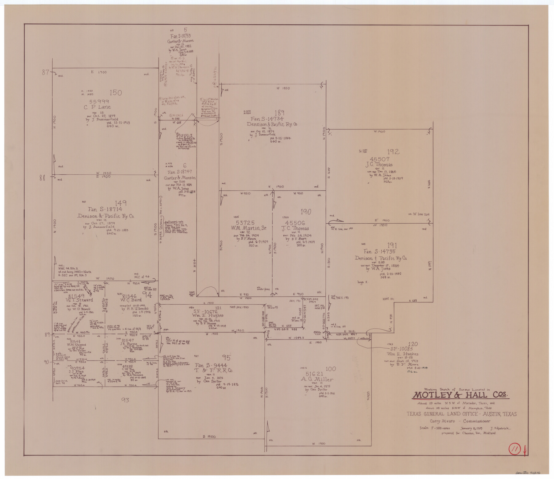
Motley County Working Sketch 11
-
Map/Doc
71216
-
Collection
General Map Collection
-
Object Dates
1/12/1989 (Creation Date)
-
People and Organizations
Joan Kilpatrick (Draftsman)
-
Counties
Motley Hall
-
Subjects
Surveying Working Sketch
-
Height x Width
28.5 x 33.0 inches
72.4 x 83.8 cm
-
Scale
1" = 300 varas
Part of: General Map Collection
Reeves County Sketch File 17

Print $40.00
- Digital $50.00
Reeves County Sketch File 17
1943
Size 9.9 x 19.4 inches
Map/Doc 35208
Flight Mission No. DQO-7K, Frame 100, Galveston County

Print $20.00
- Digital $50.00
Flight Mission No. DQO-7K, Frame 100, Galveston County
1952
Size 18.6 x 22.7 inches
Map/Doc 85115
San Jacinto County Rolled Sketch 4

Print $20.00
- Digital $50.00
San Jacinto County Rolled Sketch 4
Size 24.3 x 32.6 inches
Map/Doc 7557
Starr County Sketch File 48a

Print $40.00
- Digital $50.00
Starr County Sketch File 48a
1950
Size 9.0 x 22.0 inches
Map/Doc 37005
Hudspeth County Working Sketch 18

Print $40.00
- Digital $50.00
Hudspeth County Working Sketch 18
1957
Size 22.2 x 113.1 inches
Map/Doc 66300

Harris County Working Sketch 56

Print $20.00
- Digital $50.00
Harris County Working Sketch 56
1950
Size 33.2 x 31.6 inches
Map/Doc 65948
Bexar County Sketch File 21

Print $4.00
- Digital $50.00
Bexar County Sketch File 21
1859
Size 12.2 x 7.9 inches
Map/Doc 14484
Fisher County Rolled Sketch 4

Print $20.00
- Digital $50.00
Fisher County Rolled Sketch 4
Size 32.4 x 37.5 inches
Map/Doc 8888
Presidio County Rolled Sketch 47

Print $20.00
- Digital $50.00
Presidio County Rolled Sketch 47
1908
Size 30.8 x 32.2 inches
Map/Doc 7343
Kinney County Rolled Sketch 14

Print $20.00
- Digital $50.00
Kinney County Rolled Sketch 14
1956
Size 19.5 x 25.8 inches
Map/Doc 6543
Archer County Sketch File 16

Print $6.00
- Digital $50.00
Archer County Sketch File 16
1889
Size 12.8 x 8.3 inches
Map/Doc 13650
You may also like
2nd Chain to Long Reef, Texas

Print $40.00
- Digital $50.00
2nd Chain to Long Reef, Texas
1860
Size 30.9 x 52.6 inches
Map/Doc 69984
Presidio County Working Sketch 38

Print $20.00
- Digital $50.00
Presidio County Working Sketch 38
1948
Size 35.0 x 22.2 inches
Map/Doc 71715
[T. & N. O. Blks. 9T and 10T and surrounding areas]
![90413, [T. & N. O. Blks. 9T and 10T and surrounding areas], Twichell Survey Records](https://historictexasmaps.com/wmedia_w700/maps/90413-1.tif.jpg)
Print $20.00
- Digital $50.00
[T. & N. O. Blks. 9T and 10T and surrounding areas]
Size 14.6 x 21.0 inches
Map/Doc 90413
[Surveys along Elm Creek]
![347, [Surveys along Elm Creek], General Map Collection](https://historictexasmaps.com/wmedia_w700/maps/347.tif.jpg)
Print $2.00
- Digital $50.00
[Surveys along Elm Creek]
1846
Size 12.0 x 7.4 inches
Map/Doc 347
San Patricio County

Print $40.00
- Digital $50.00
San Patricio County
1939
Size 39.3 x 48.3 inches
Map/Doc 73283
[G. C. & S. F. Ry., San Saba Branch, Right of Way Map, Brady to Melvin]
![61421, [G. C. & S. F. Ry., San Saba Branch, Right of Way Map, Brady to Melvin], General Map Collection](https://historictexasmaps.com/wmedia_w700/maps/61421.tif.jpg)
Print $40.00
- Digital $50.00
[G. C. & S. F. Ry., San Saba Branch, Right of Way Map, Brady to Melvin]
1916
Size 37.7 x 121.5 inches
Map/Doc 61421
Brooks County Boundary File 1a

Print $40.00
- Digital $50.00
Brooks County Boundary File 1a
Size 63.8 x 7.1 inches
Map/Doc 50836

Chart showing the relative positions of the lights in the Eighth Light House District extending from Cedar Keys, Florida to Rio Grande, Texas

Print $20.00
- Digital $50.00
Chart showing the relative positions of the lights in the Eighth Light House District extending from Cedar Keys, Florida to Rio Grande, Texas
1876
Size 24.7 x 18.2 inches
Map/Doc 72680
Map of Cameron County Drainage District Number One

Print $20.00
- Digital $50.00
Map of Cameron County Drainage District Number One
1929
Size 46.6 x 31.0 inches
Map/Doc 94245
[San Antonio & Aransas Pass Railway Co.]
![64262, [San Antonio & Aransas Pass Railway Co.], General Map Collection](https://historictexasmaps.com/wmedia_w700/maps/64262-1.tif.jpg)
Print $40.00
- Digital $50.00
[San Antonio & Aransas Pass Railway Co.]
Size 15.7 x 86.4 inches
Map/Doc 64262
Index for Texas Railroad ROW & track maps available on microfilm at THD & Archives and Records

Print $2.00
- Digital $50.00
Index for Texas Railroad ROW & track maps available on microfilm at THD & Archives and Records
1977
Size 11.2 x 8.8 inches
Map/Doc 60757