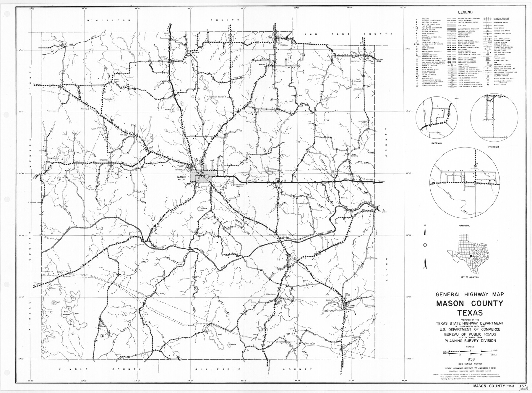
General Highway Map, Mason County, Texas
-
Map/Doc
79584
-
Collection
Texas State Library and Archives
-
Object Dates
1961 (Creation Date)
-
People and Organizations
Texas State Highway Department (Publisher)
-
Counties
Mason
-
Subjects
County
-
Height x Width
18.3 x 24.8 inches
46.5 x 63.0 cm
-
Comments
Prints available courtesy of the Texas State Library and Archives.
More info can be found here: TSLAC Map 05229
Part of: Texas State Library and Archives
General Highway Map, Lubbock County, Texas

Print $20.00
General Highway Map, Lubbock County, Texas
1961
Size 18.1 x 24.6 inches
Map/Doc 79578
Stremme General Land Office Drawings, front view

Print $20.00
Stremme General Land Office Drawings, front view
Size 14.0 x 20.8 inches
Map/Doc 79738
General Highway Map, Wichita County, Texas

Print $20.00
General Highway Map, Wichita County, Texas
1961
Size 18.2 x 24.6 inches
Map/Doc 79709
General Highway Map, El Paso County, Texas

Print $20.00
General Highway Map, El Paso County, Texas
1961
Size 18.2 x 24.7 inches
Map/Doc 79454
Reconnoissances of Routes from San Antonio de Bexar to El Paso Del Norte

Print $20.00
Reconnoissances of Routes from San Antonio de Bexar to El Paso Del Norte
1849
Size 27.5 x 39.6 inches
Map/Doc 76239
Map of New Braunfels, Comal County, Texas

Print $20.00
Map of New Braunfels, Comal County, Texas
1868
Size 19.0 x 25.1 inches
Map/Doc 76282
General Highway Map, Austin County, Texas

Print $20.00
General Highway Map, Austin County, Texas
1961
Size 18.1 x 25.1 inches
Map/Doc 79357
General Highway Map, Goliad County, Texas

Print $20.00
General Highway Map, Goliad County, Texas
1961
Size 18.2 x 24.7 inches
Map/Doc 79481
General Highway Map, Delta County, Hopkins County, Texas

Print $20.00
General Highway Map, Delta County, Hopkins County, Texas
1940
Size 25.2 x 18.5 inches
Map/Doc 79073
General Highway Map, Harris County, Texas

Print $20.00
General Highway Map, Harris County, Texas
1961
Size 24.9 x 18.0 inches
Map/Doc 79502
General Highway Map, Freestone County, Texas

Print $20.00
General Highway Map, Freestone County, Texas
1961
Size 18.1 x 24.8 inches
Map/Doc 79472
General Highway Map, Karnes County, Texas

Print $20.00
General Highway Map, Karnes County, Texas
1961
Size 18.1 x 24.6 inches
Map/Doc 79547
You may also like
![92508, [Block A31], Twichell Survey Records](https://historictexasmaps.com/wmedia_w700/maps/92508-1.tif.jpg)
American Civil War Political Loyalties

American Civil War Political Loyalties
2022
Size 8.5 x 11.0 inches
Map/Doc 97091
Brewster County Working Sketch 9

Print $20.00
- Digital $50.00
Brewster County Working Sketch 9
1910
Size 14.3 x 14.4 inches
Map/Doc 67542
Harris County Working Sketch 10

Print $20.00
- Digital $50.00
Harris County Working Sketch 10
1912
Size 25.7 x 18.1 inches
Map/Doc 65902
Souvenir of Galveston the Sea Wall City

Souvenir of Galveston the Sea Wall City
Size 5.7 x 7.6 inches
Map/Doc 97051
Baylor County Sketch File 21

Print $40.00
- Digital $50.00
Baylor County Sketch File 21
Size 17.5 x 30.7 inches
Map/Doc 10908
Calhoun County NRC Article 33.136 Sketch 6

Print $24.00
- Digital $50.00
Calhoun County NRC Article 33.136 Sketch 6
2014
Size 18.0 x 24.0 inches
Map/Doc 94462
Fort Bend County State Real Property Sketch 8

Print $40.00
- Digital $50.00
Fort Bend County State Real Property Sketch 8
1985
Size 35.0 x 43.6 inches
Map/Doc 61682
Map of Texas and Adjacent Regions in the Eighteenth Century

Print $20.00
Map of Texas and Adjacent Regions in the Eighteenth Century
1915
Size 19.3 x 23.3 inches
Map/Doc 79743
Culberson County Working Sketch 64

Print $20.00
- Digital $50.00
Culberson County Working Sketch 64
1975
Size 46.5 x 30.8 inches
Map/Doc 68518
Land of the Maya, a Traveler's Map

Land of the Maya, a Traveler's Map
Size 27.2 x 20.5 inches
Map/Doc 95933
Flight Mission No. DCL-7C, Frame 43, Kenedy County

Print $20.00
- Digital $50.00
Flight Mission No. DCL-7C, Frame 43, Kenedy County
1943
Size 15.5 x 15.5 inches
Map/Doc 86031