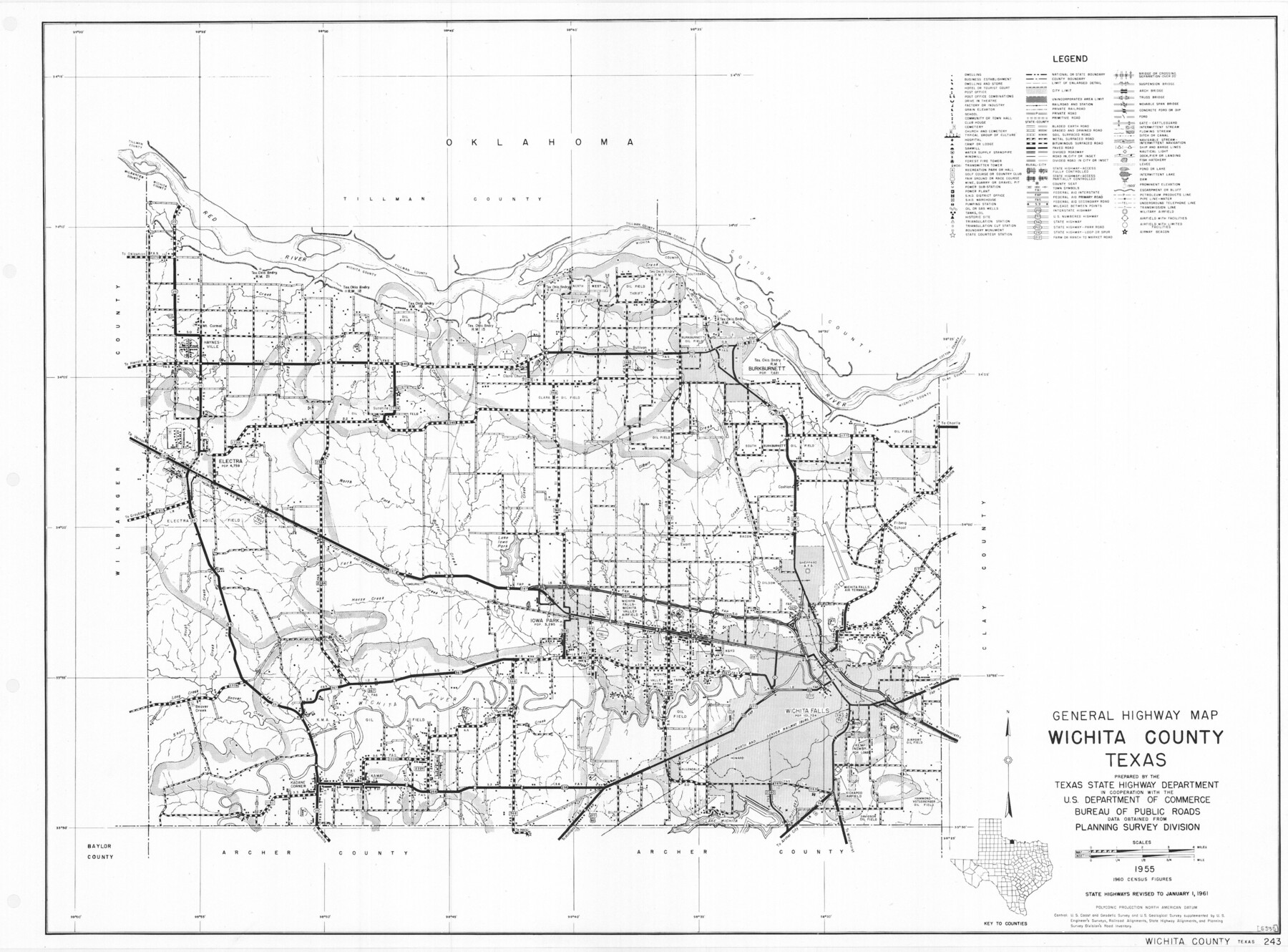
General Highway Map, Wichita County, Texas
-
Map/Doc
79709
-
Collection
Texas State Library and Archives
-
Object Dates
1961 (Creation Date)
-
People and Organizations
Texas State Highway Department (Publisher)
-
Counties
Wichita
-
Subjects
County
-
Height x Width
18.2 x 24.6 inches
46.2 x 62.5 cm
-
Comments
Prints available courtesy of the Texas State Library and Archives.
More info can be found here: TSLAC Map 05335
Part of: Texas State Library and Archives
Topographic Map of Texas and Oklahoma Boundary, Fort Augur Area

Print $20.00
Topographic Map of Texas and Oklahoma Boundary, Fort Augur Area
1924
Size 22.1 x 38.3 inches
Map/Doc 79752
Map of Bexar County Oil Fields

Print $40.00
Map of Bexar County Oil Fields
1919
Size 37.6 x 49.0 inches
Map/Doc 79307
General Highway Map, Polk County, Texas

Print $20.00
General Highway Map, Polk County, Texas
1940
Size 24.6 x 18.5 inches
Map/Doc 79219
Map of the Republic of Texas and the Adjacent Territories, Indicating the Grants of Land Conceded under the Empresario System of Mexico

Print $20.00
Map of the Republic of Texas and the Adjacent Territories, Indicating the Grants of Land Conceded under the Empresario System of Mexico
1841
Size 13.4 x 16.7 inches
Map/Doc 76244
General Highway Map. Detail of Cities and Towns in Harris County, Texas

Print $20.00
General Highway Map. Detail of Cities and Towns in Harris County, Texas
1961
Size 18.2 x 24.6 inches
Map/Doc 79503
General Highway Map. Detail of Cities and Towns in Bowie County, Texas

Print $20.00
General Highway Map. Detail of Cities and Towns in Bowie County, Texas
1961
Size 18.0 x 24.8 inches
Map/Doc 79381
General Highway Map, Jim Wells County, Texas

Print $20.00
General Highway Map, Jim Wells County, Texas
1940
Size 18.4 x 24.8 inches
Map/Doc 79148
General Highway Map. Detail of Cities and Towns in Cameron County, Texas [San Benito, Harlingen, Brownsville and vicinity]
![79399, General Highway Map. Detail of Cities and Towns in Cameron County, Texas [San Benito, Harlingen, Brownsville and vicinity], Texas State Library and Archives](https://historictexasmaps.com/wmedia_w700/maps/79399.tif.jpg)
Print $20.00
General Highway Map. Detail of Cities and Towns in Cameron County, Texas [San Benito, Harlingen, Brownsville and vicinity]
1961
Size 18.0 x 24.7 inches
Map/Doc 79399
General Highway Map, Nueces County, Texas

Print $20.00
General Highway Map, Nueces County, Texas
1940
Size 24.6 x 18.5 inches
Map/Doc 79209
General Highway Map, Falls County, Texas

Print $20.00
General Highway Map, Falls County, Texas
1961
Size 18.2 x 24.5 inches
Map/Doc 79462
General Highway Map. Detail of Cities and Towns in Potter County, Texas [Amarillo and vicinity]
![79221, General Highway Map. Detail of Cities and Towns in Potter County, Texas [Amarillo and vicinity], Texas State Library and Archives](https://historictexasmaps.com/wmedia_w700/maps/79221.tif.jpg)
Print $20.00
General Highway Map. Detail of Cities and Towns in Potter County, Texas [Amarillo and vicinity]
1940
Size 24.6 x 18.2 inches
Map/Doc 79221
General Highway Map, Brewster County, Texas

Print $20.00
General Highway Map, Brewster County, Texas
1940
Size 18.5 x 25.1 inches
Map/Doc 79028
You may also like
Concho County Sketch File 27

Print $8.00
- Digital $50.00
Concho County Sketch File 27
1885
Size 11.3 x 8.8 inches
Map/Doc 19162
[Blocks 24, O, J, and L]
![92651, [Blocks 24, O, J, and L], Twichell Survey Records](https://historictexasmaps.com/wmedia_w700/maps/92651-1.tif.jpg)
Print $20.00
- Digital $50.00
[Blocks 24, O, J, and L]
Size 39.3 x 26.6 inches
Map/Doc 92651
Reagan County Sketch File 6

Print $20.00
- Digital $50.00
Reagan County Sketch File 6
1927
Size 23.4 x 14.1 inches
Map/Doc 12215
Taylor County Working Sketch 11

Print $20.00
- Digital $50.00
Taylor County Working Sketch 11
1956
Size 23.0 x 24.4 inches
Map/Doc 69621
Hutchinson County Rolled Sketch 41

Print $40.00
- Digital $50.00
Hutchinson County Rolled Sketch 41
1989
Size 43.3 x 144.5 inches
Map/Doc 9249
Flight Mission No. DCL-6C, Frame 54, Kenedy County

Print $20.00
- Digital $50.00
Flight Mission No. DCL-6C, Frame 54, Kenedy County
1943
Size 18.6 x 22.4 inches
Map/Doc 85896
Fractional Township No. 8 South Range No. 6 East of the Indian Meridian, Indian Territory

Print $20.00
- Digital $50.00
Fractional Township No. 8 South Range No. 6 East of the Indian Meridian, Indian Territory
1898
Size 19.3 x 24.4 inches
Map/Doc 75210
[Nathaniel H. Cochran Survey and Vicinity]
![91496, [Nathaniel H. Cochran Survey and Vicinity], Twichell Survey Records](https://historictexasmaps.com/wmedia_w700/maps/91496-1.tif.jpg)
Print $20.00
- Digital $50.00
[Nathaniel H. Cochran Survey and Vicinity]
1922
Size 22.5 x 21.9 inches
Map/Doc 91496
Pecos County Sketch File 28a

Print $14.00
- Digital $50.00
Pecos County Sketch File 28a
1911
Size 14.5 x 8.9 inches
Map/Doc 33683
Palo Pinto County

Print $40.00
- Digital $50.00
Palo Pinto County
1941
Size 48.3 x 39.4 inches
Map/Doc 66966
Val Verde County Working Sketch 48

Print $20.00
- Digital $50.00
Val Verde County Working Sketch 48
1949
Size 32.6 x 17.6 inches
Map/Doc 72183
Travis County Sketch File 56

Print $6.00
- Digital $50.00
Travis County Sketch File 56
1945
Size 14.2 x 9.0 inches
Map/Doc 38398