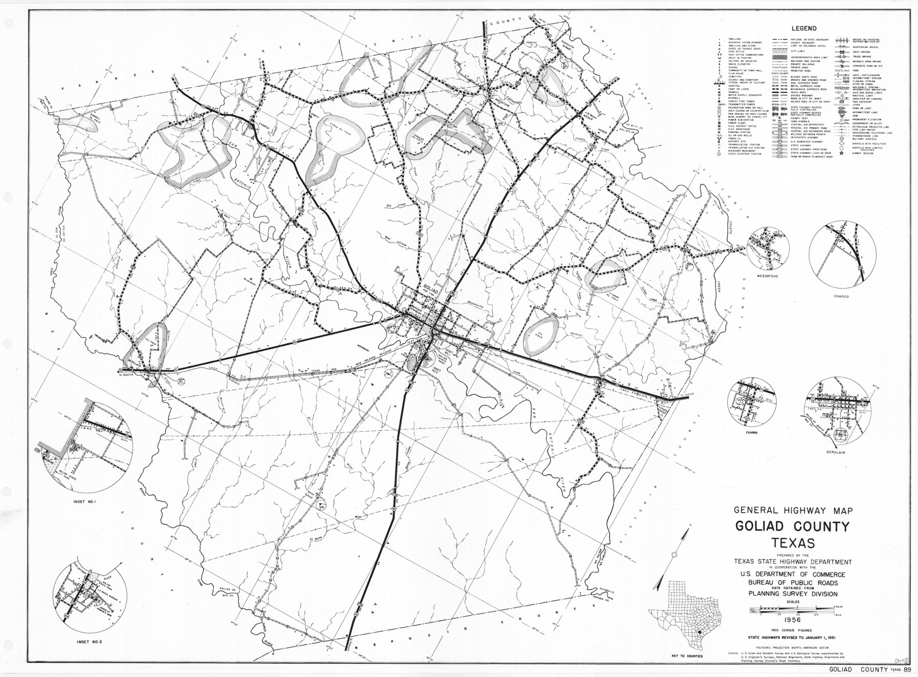
General Highway Map, Goliad County, Texas
-
Map/Doc
79481
-
Collection
Texas State Library and Archives
-
Object Dates
1961 (Creation Date)
-
People and Organizations
Texas State Highway Department (Publisher)
-
Counties
Goliad
-
Subjects
County
-
Height x Width
18.2 x 24.7 inches
46.2 x 62.7 cm
-
Comments
Prints available courtesy of the Texas State Library and Archives.
More info can be found here: TSLAC Map 05143
Part of: Texas State Library and Archives
General Highway Map, Presidio County, Texas

Print $20.00
General Highway Map, Presidio County, Texas
1940
Size 24.6 x 18.3 inches
Map/Doc 79222
General Highway Map, Maverick County, Texas

Print $20.00
General Highway Map, Maverick County, Texas
1961
Size 18.2 x 24.6 inches
Map/Doc 79587
General Highway Map, Hutchinson County, Texas

Print $20.00
General Highway Map, Hutchinson County, Texas
1961
Size 18.1 x 24.6 inches
Map/Doc 79529
General Highway Map, Victoria County, Texas

Print $20.00
General Highway Map, Victoria County, Texas
1940
Size 24.8 x 18.5 inches
Map/Doc 79268
General Highway Map, Kleberg County, Texas

Print $20.00
General Highway Map, Kleberg County, Texas
1961
Size 24.6 x 18.3 inches
Map/Doc 79559
General Highway Map, Panola County, Texas

Print $20.00
General Highway Map, Panola County, Texas
1940
Size 18.2 x 24.6 inches
Map/Doc 79214
General Highway Map, Harris County, Texas

Print $20.00
General Highway Map, Harris County, Texas
1961
Size 24.9 x 18.0 inches
Map/Doc 79502
General Highway Map, Brown County, Texas

Print $20.00
General Highway Map, Brown County, Texas
1940
Size 25.0 x 18.4 inches
Map/Doc 79031
General Highway Map, Bosque County, Texas

Print $20.00
General Highway Map, Bosque County, Texas
1961
Size 24.7 x 18.1 inches
Map/Doc 79378
Rand McNally Standard Map of Texas (reverse)

Print $20.00
Rand McNally Standard Map of Texas (reverse)
1923
Size 39.8 x 27.2 inches
Map/Doc 76229
Map of Texas with Parts of the Adjoining States

Print $20.00
Map of Texas with Parts of the Adjoining States
1833
Size 29.3 x 23.3 inches
Map/Doc 79740
General Highway Map, Winkler County, Texas

Print $20.00
General Highway Map, Winkler County, Texas
1961
Size 18.2 x 24.8 inches
Map/Doc 79716
You may also like
Palo Pinto County, Texas

Print $20.00
Palo Pinto County, Texas
Size 24.6 x 19.5 inches
Map/Doc 88986
Flight Mission No. BRE-4P, Frame 170, Nueces County

Print $20.00
- Digital $50.00
Flight Mission No. BRE-4P, Frame 170, Nueces County
1956
Size 18.5 x 22.6 inches
Map/Doc 86833
Flight Mission No. DAG-21K, Frame 41, Matagorda County

Print $20.00
- Digital $50.00
Flight Mission No. DAG-21K, Frame 41, Matagorda County
1952
Size 18.6 x 19.3 inches
Map/Doc 86408
Smith Co. showing location of Texas and Pacific Railway

Print $20.00
- Digital $50.00
Smith Co. showing location of Texas and Pacific Railway
1872
Size 19.5 x 21.6 inches
Map/Doc 64139
Old Miscellaneous File 20

Print $16.00
- Digital $50.00
Old Miscellaneous File 20
1913
Size 13.6 x 7.9 inches
Map/Doc 75575
Johnson County

Print $20.00
- Digital $50.00
Johnson County
1859
Size 22.0 x 29.6 inches
Map/Doc 3732
Van Zandt County Sketch File 23

Print $4.00
- Digital $50.00
Van Zandt County Sketch File 23
1858
Size 6.8 x 8.2 inches
Map/Doc 39437
[Location Survey of the Southern Kansas Railway, Kiowa Extension from a point in Drake's Location, in Indian Territory 100 miles from south line of Kansas, continuing up Wolf Creek and South Canadian River to Cottonwood Creek in Hutchinson County]
![88843, [Location Survey of the Southern Kansas Railway, Kiowa Extension from a point in Drake's Location, in Indian Territory 100 miles from south line of Kansas, continuing up Wolf Creek and South Canadian River to Cottonwood Creek in Hutchinson County], General Map Collection](https://historictexasmaps.com/wmedia_w700/maps/88843.tif.jpg)
Print $20.00
- Digital $50.00
[Location Survey of the Southern Kansas Railway, Kiowa Extension from a point in Drake's Location, in Indian Territory 100 miles from south line of Kansas, continuing up Wolf Creek and South Canadian River to Cottonwood Creek in Hutchinson County]
1886
Size 39.0 x 40.0 inches
Map/Doc 88843
Amistad International Reservoir on Rio Grande 108

Print $20.00
- Digital $50.00
Amistad International Reservoir on Rio Grande 108
1950
Size 28.5 x 40.9 inches
Map/Doc 75539
Presidio County Rolled Sketch WR1

Print $20.00
- Digital $50.00
Presidio County Rolled Sketch WR1
1927
Size 20.4 x 23.0 inches
Map/Doc 7421
[Sketch for Mineral Application 11108 - Greens Bayou]
![76156, [Sketch for Mineral Application 11108 - Greens Bayou], General Map Collection](https://historictexasmaps.com/wmedia_w700/maps/76156.tif.jpg)
Print $40.00
- Digital $50.00
[Sketch for Mineral Application 11108 - Greens Bayou]
Size 58.2 x 31.4 inches
Map/Doc 76156
Real County Sketch File 10

Print $6.00
- Digital $50.00
Real County Sketch File 10
1932
Size 10.3 x 15.0 inches
Map/Doc 35063