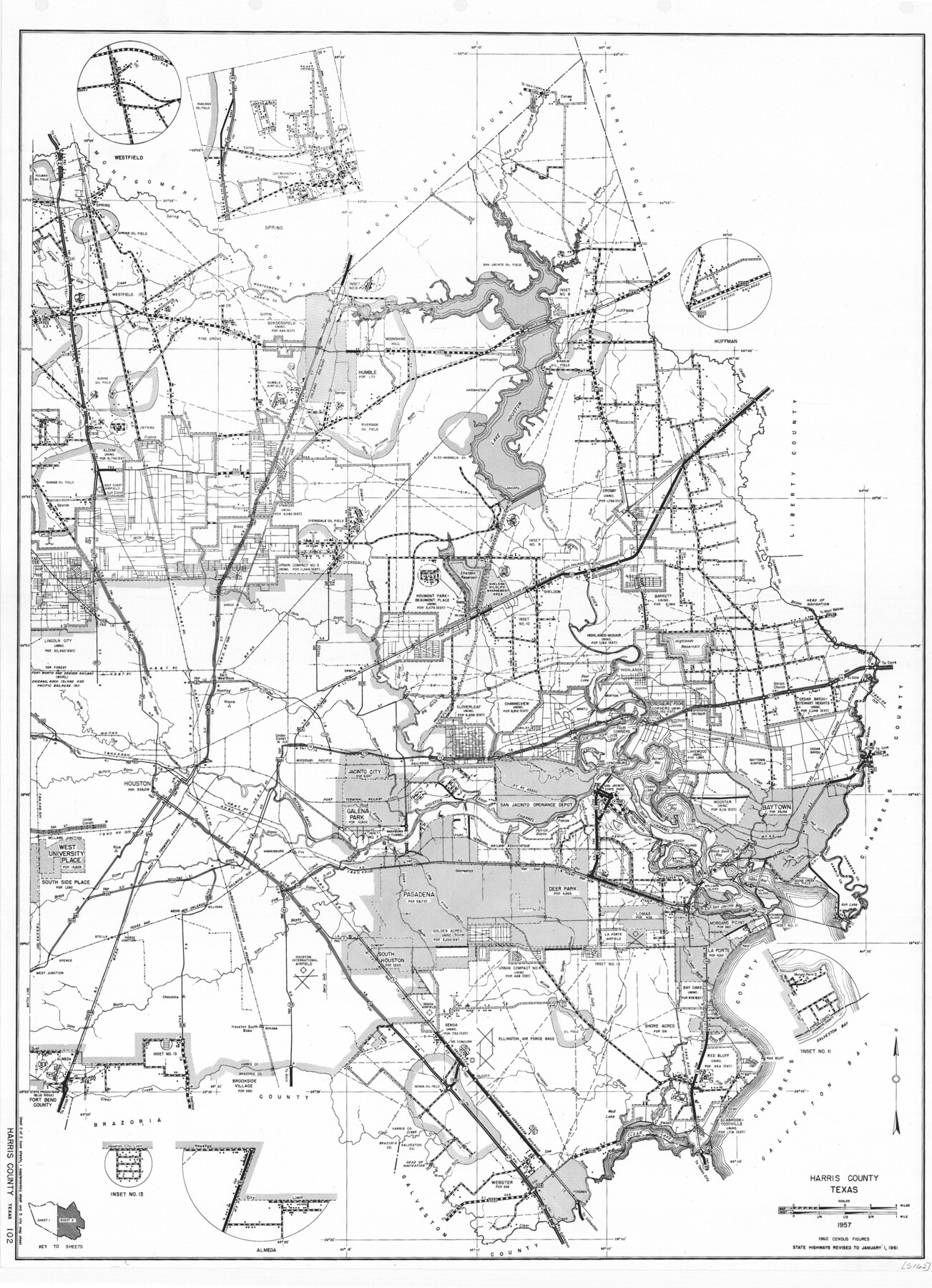
General Highway Map, Harris County, Texas
-
Map/Doc
79502
-
Collection
Texas State Library and Archives
-
Object Dates
1961 (Creation Date)
-
People and Organizations
Texas State Highway Department (Publisher)
-
Counties
Harris
-
Subjects
County
-
Height x Width
24.9 x 18.0 inches
63.3 x 45.7 cm
-
Comments
Prints available courtesy of the Texas State Library and Archives.
More info can be found here: TSLAC Map 05162
Part of: Texas State Library and Archives
General Highway Map. Detail of Cities and Towns in Bexar County, Texas. City Map of San Antonio, Alamo Heights, Olmos Park, Terrell Hills, Castle Hills, Balcones Heights, and vicinity, Bexar County, Texas

Print $20.00
General Highway Map. Detail of Cities and Towns in Bexar County, Texas. City Map of San Antonio, Alamo Heights, Olmos Park, Terrell Hills, Castle Hills, Balcones Heights, and vicinity, Bexar County, Texas
1961
Size 18.1 x 25.1 inches
Map/Doc 79373
General Highway Map, Lamb County, Texas

Print $20.00
General Highway Map, Lamb County, Texas
1940
Size 24.7 x 18.3 inches
Map/Doc 79168
General Highway Map, Swisher County, Texas

Print $20.00
General Highway Map, Swisher County, Texas
1961
Size 18.3 x 25.0 inches
Map/Doc 79663
General Highway Map, Cameron County, Texas

Print $20.00
General Highway Map, Cameron County, Texas
1940
Size 18.4 x 25.3 inches
Map/Doc 79038
General Highway Map, Nolan County, Texas

Print $20.00
General Highway Map, Nolan County, Texas
1940
Size 18.4 x 24.7 inches
Map/Doc 79208
General Highway Map, Carson County, Texas

Print $20.00
General Highway Map, Carson County, Texas
1940
Size 18.5 x 25.1 inches
Map/Doc 79041
A New Map of Texas with the Contiguous American & Mexican States

Print $20.00
A New Map of Texas with the Contiguous American & Mexican States
1835
Size 13.5 x 16.1 inches
Map/Doc 76185
Map of Texas and Adjacent Regions in the Eighteenth Century

Print $20.00
Map of Texas and Adjacent Regions in the Eighteenth Century
1915
Size 19.3 x 23.3 inches
Map/Doc 79743
General Highway Map, Sabine County, Texas

Print $20.00
General Highway Map, Sabine County, Texas
1940
Size 24.7 x 18.3 inches
Map/Doc 79233
[Plat of Victoria, Texas]
![76270, [Plat of Victoria, Texas], Texas State Library and Archives](https://historictexasmaps.com/wmedia_w700/maps/76270.tif.jpg)
Print $20.00
[Plat of Victoria, Texas]
1850
Size 14.1 x 11.5 inches
Map/Doc 76270
General Highway Map. Detail of Cities and Towns in Gray County, Texas. [Pampa and vicinity]
![79484, General Highway Map. Detail of Cities and Towns in Gray County, Texas. [Pampa and vicinity], Texas State Library and Archives](https://historictexasmaps.com/wmedia_w700/maps/79484.tif.jpg)
Print $20.00
General Highway Map. Detail of Cities and Towns in Gray County, Texas. [Pampa and vicinity]
1961
Size 24.7 x 18.1 inches
Map/Doc 79484
General Highway Map, Donley County, Texas

Print $20.00
General Highway Map, Donley County, Texas
1940
Size 25.1 x 18.3 inches
Map/Doc 79078
You may also like
Gregg County Sketch File 1H

Print $2.00
- Digital $50.00
Gregg County Sketch File 1H
Size 5.8 x 5.4 inches
Map/Doc 24550
[Right of Way & Track Map, The Texas & Pacific Ry. Co. Main Line]
![64673, [Right of Way & Track Map, The Texas & Pacific Ry. Co. Main Line], General Map Collection](https://historictexasmaps.com/wmedia_w700/maps/64673.tif.jpg)
Print $20.00
- Digital $50.00
[Right of Way & Track Map, The Texas & Pacific Ry. Co. Main Line]
Size 11.2 x 18.6 inches
Map/Doc 64673
Flight Mission No. DQN-5K, Frame 60, Calhoun County

Print $20.00
- Digital $50.00
Flight Mission No. DQN-5K, Frame 60, Calhoun County
1953
Size 15.5 x 15.4 inches
Map/Doc 84403
Map representing the surveys made in Bexar County

Print $40.00
- Digital $50.00
Map representing the surveys made in Bexar County
1839
Size 75.7 x 35.1 inches
Map/Doc 93365
Culberson County Working Sketch 54

Print $20.00
- Digital $50.00
Culberson County Working Sketch 54
1974
Size 26.4 x 32.6 inches
Map/Doc 68508
Webb County Working Sketch 65

Print $40.00
- Digital $50.00
Webb County Working Sketch 65
1964
Size 49.0 x 59.5 inches
Map/Doc 72431
Guadalupe County

Print $20.00
- Digital $50.00
Guadalupe County
1869
Size 27.7 x 22.3 inches
Map/Doc 3607
Ellis County Sketch File 5

Print $4.00
- Digital $50.00
Ellis County Sketch File 5
Size 10.3 x 8.2 inches
Map/Doc 21834
Midland County Sketch File 5

Print $2.00
- Digital $50.00
Midland County Sketch File 5
Size 8.4 x 3.5 inches
Map/Doc 31575
Map of Mason County

Print $20.00
- Digital $50.00
Map of Mason County
1879
Size 22.5 x 18.8 inches
Map/Doc 3839
Harris County Boundary File 39 (1)

Print $45.00
- Digital $50.00
Harris County Boundary File 39 (1)
Size 4.5 x 16.3 inches
Map/Doc 54326
McMullen County Working Sketch 25

Print $20.00
- Digital $50.00
McMullen County Working Sketch 25
1952
Size 37.5 x 43.5 inches
Map/Doc 70726