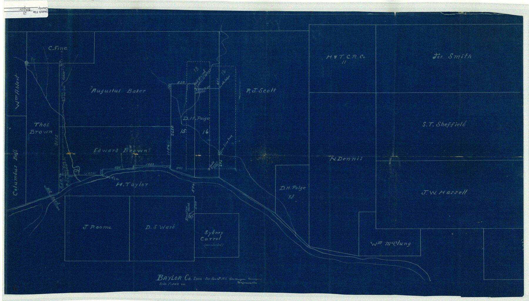
Baylor County Sketch File 21
[Baylor County sketch showing D.H. Paige surveys on Brazos River and surrounding area]
-
Map/Doc
10908
-
Collection
General Map Collection
-
Object Dates
1911/1/16 (Survey Date)
-
People and Organizations
J.M. Morgan (Surveyor/Engineer)
-
Counties
Baylor
-
Subjects
Surveying Sketch File
-
Height x Width
17.5 x 30.7 inches
44.5 x 78.0 cm
-
Medium
blueprint/diazo
-
Scale
1" = 500 varas
-
Features
Old Road
Part of: General Map Collection
[Gulf Coast portion of] Map of the State of Texas
![72707, [Gulf Coast portion of] Map of the State of Texas, General Map Collection](https://historictexasmaps.com/wmedia_w700/maps/72707.tif.jpg)
Print $20.00
- Digital $50.00
[Gulf Coast portion of] Map of the State of Texas
1865
Size 27.4 x 18.1 inches
Map/Doc 72707
Trinity County Working Sketch 3

Print $20.00
- Digital $50.00
Trinity County Working Sketch 3
1905
Size 26.7 x 19.2 inches
Map/Doc 69451
Maps of Gulf Intracoastal Waterway, Texas - Sabine River to the Rio Grande and connecting waterways including ship channels

Print $20.00
- Digital $50.00
Maps of Gulf Intracoastal Waterway, Texas - Sabine River to the Rio Grande and connecting waterways including ship channels
1966
Size 14.6 x 22.2 inches
Map/Doc 61970
McCulloch County Sketch File 5A

Print $20.00
- Digital $50.00
McCulloch County Sketch File 5A
Size 14.8 x 17.4 inches
Map/Doc 12056
Terrell County Working Sketch 84d

Print $20.00
- Digital $50.00
Terrell County Working Sketch 84d
1992
Size 18.4 x 31.5 inches
Map/Doc 69608
Smith County Rolled Sketch 3

Print $40.00
- Digital $50.00
Smith County Rolled Sketch 3
Size 55.2 x 42.8 inches
Map/Doc 9934
Grayson County Fannin District

Print $20.00
- Digital $50.00
Grayson County Fannin District
1885
Size 40.1 x 37.7 inches
Map/Doc 4961
Plat of a survey on Padre Island in Willacy and Kenedy Counties surveyed for South Padre Development Corporation by Claunch and Associates

Print $20.00
- Digital $50.00
Plat of a survey on Padre Island in Willacy and Kenedy Counties surveyed for South Padre Development Corporation by Claunch and Associates
1973
Size 46.5 x 41.6 inches
Map/Doc 61424
Bandera County Working Sketch 14

Print $20.00
- Digital $50.00
Bandera County Working Sketch 14
1934
Size 28.0 x 30.9 inches
Map/Doc 67607
Loving County Sketch File 5

Print $10.00
- Digital $50.00
Loving County Sketch File 5
Size 9.7 x 8.3 inches
Map/Doc 30412
Travis County Appraisal District Plat Map 3_0721

Print $20.00
- Digital $50.00
Travis County Appraisal District Plat Map 3_0721
Size 21.5 x 26.3 inches
Map/Doc 94227
Refugio County Sketch File 23

Print $6.00
- Digital $50.00
Refugio County Sketch File 23
1948
Size 11.2 x 8.7 inches
Map/Doc 35280
You may also like
Carta Eclesiastica

Print $20.00
- Digital $50.00
Carta Eclesiastica
1897
Size 26.1 x 34.1 inches
Map/Doc 96799
Flight Mission No. BQR-13K, Frame 116, Brazoria County

Print $20.00
- Digital $50.00
Flight Mission No. BQR-13K, Frame 116, Brazoria County
1952
Size 18.7 x 22.4 inches
Map/Doc 84077
Flight Mission No. BQY-4M, Frame 113, Harris County

Print $20.00
- Digital $50.00
Flight Mission No. BQY-4M, Frame 113, Harris County
1953
Size 18.8 x 22.4 inches
Map/Doc 85280
Llano County Sketch File 10

Print $10.00
- Digital $50.00
Llano County Sketch File 10
1886
Size 8.2 x 7.6 inches
Map/Doc 30370
Val Verde County Sketch File 8

Print $38.00
- Digital $50.00
Val Verde County Sketch File 8
1885
Size 22.6 x 23.2 inches
Map/Doc 12564
Hudspeth County Sketch File 31

Print $20.00
- Digital $50.00
Hudspeth County Sketch File 31
1908
Size 18.7 x 17.7 inches
Map/Doc 11805
Starr County Working Sketch 19

Print $20.00
- Digital $50.00
Starr County Working Sketch 19
1982
Size 27.3 x 33.9 inches
Map/Doc 63935
Texas State Capitol Land

Print $40.00
- Digital $50.00
Texas State Capitol Land
1915
Size 76.6 x 55.6 inches
Map/Doc 93156
Sketch from Reeves and Pecos Co's.

Print $20.00
- Digital $50.00
Sketch from Reeves and Pecos Co's.
Size 35.1 x 26.1 inches
Map/Doc 91779
Garza County Rolled Sketch 6B

Print $20.00
- Digital $50.00
Garza County Rolled Sketch 6B
Size 27.6 x 36.4 inches
Map/Doc 5996
Flight Mission No. CUG-2P, Frame 83, Kleberg County

Print $20.00
- Digital $50.00
Flight Mission No. CUG-2P, Frame 83, Kleberg County
1956
Size 18.5 x 22.3 inches
Map/Doc 86215
Ochiltree County Boundary File 6

Print $4.00
- Digital $50.00
Ochiltree County Boundary File 6
Size 11.1 x 8.6 inches
Map/Doc 57713