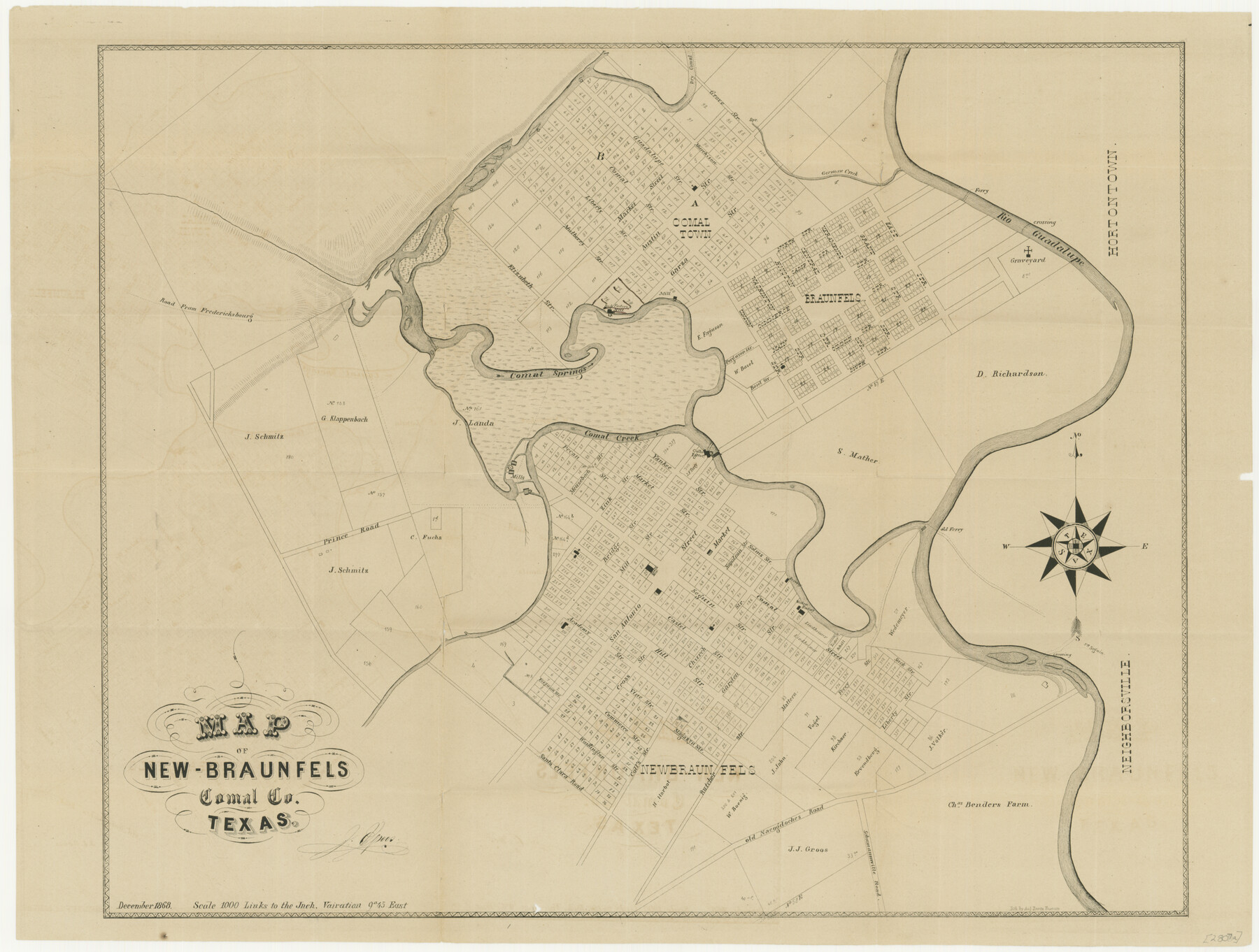
Map of New Braunfels, Comal County, Texas
-
Map/Doc
76282
-
Collection
Texas State Library and Archives
-
Object Dates
1868 (Creation Date)
-
People and Organizations
J.J. Groos (Surveyor/Engineer)
-
Counties
Comal
-
Subjects
City
-
Height x Width
19.0 x 25.1 inches
48.3 x 63.8 cm
-
Comments
Prints available courtesy of the Texas State Library and Archives.
More info can be found here: TSLAC Map 02807a
Part of: Texas State Library and Archives
General Highway Map, Upton County, Texas

Print $20.00
General Highway Map, Upton County, Texas
1940
Size 24.8 x 18.1 inches
Map/Doc 79265
General Highway Map. Detail of Cities and Towns in Tarrant County, Texas. City Map, Fort Worth and vicinity, Tarrant County, Texas

Print $20.00
General Highway Map. Detail of Cities and Towns in Tarrant County, Texas. City Map, Fort Worth and vicinity, Tarrant County, Texas
1961
Size 18.2 x 24.9 inches
Map/Doc 79667
General Highway Map, Wichita County, Texas

Print $20.00
General Highway Map, Wichita County, Texas
1961
Size 18.2 x 24.6 inches
Map/Doc 79709
General Highway Map. Detail of Cities and Towns in Tarrant County, Texas [Fort Worth and vicinity]
![79253, General Highway Map. Detail of Cities and Towns in Tarrant County, Texas [Fort Worth and vicinity], Texas State Library and Archives](https://historictexasmaps.com/wmedia_w700/maps/79253-GC.tif.jpg)
Print $20.00
General Highway Map. Detail of Cities and Towns in Tarrant County, Texas [Fort Worth and vicinity]
1940
Size 24.8 x 18.4 inches
Map/Doc 79253
General Highway Map, Rusk County, Texas

Print $20.00
General Highway Map, Rusk County, Texas
1939
Size 24.7 x 18.2 inches
Map/Doc 79232
Correct Map of the Railway and Steamship Lines operated by the Southern Pacific Company

Print $20.00
Correct Map of the Railway and Steamship Lines operated by the Southern Pacific Company
1894
Size 17.1 x 40.1 inches
Map/Doc 79322
General Highway Map, Tarrant County, Texas

Print $20.00
General Highway Map, Tarrant County, Texas
1940
Size 18.4 x 25.2 inches
Map/Doc 79251
The Federal Aid Highway System Progress Map

Print $20.00
The Federal Aid Highway System Progress Map
1931
Size 31.4 x 22.1 inches
Map/Doc 79745
Preliminary Chart of the Northwestern Part of the Gulf of Mexico

Print $20.00
Preliminary Chart of the Northwestern Part of the Gulf of Mexico
1855
Size 32.3 x 41.6 inches
Map/Doc 79334
Preliminary Chart of the Entrance to Matagorda Bay, Texas

Print $20.00
Preliminary Chart of the Entrance to Matagorda Bay, Texas
1857
Size 20.2 x 32.9 inches
Map/Doc 76247
Worley's Map of Greater Dallas

Print $20.00
Worley's Map of Greater Dallas
1905
Size 34.9 x 25.4 inches
Map/Doc 79319
General Highway Map, Sherman County, Texas

Print $20.00
General Highway Map, Sherman County, Texas
1961
Size 18.2 x 24.8 inches
Map/Doc 79653
You may also like
Brooks County Working Sketch 14

Print $20.00
- Digital $50.00
Brooks County Working Sketch 14
1944
Size 29.2 x 20.0 inches
Map/Doc 67798
Map of the United States and Canada

Print $2.00
- Digital $50.00
Map of the United States and Canada
1853
Size 6.2 x 4.2 inches
Map/Doc 93919
The Republic County of Shelby. January 16, 1843

Print $20.00
The Republic County of Shelby. January 16, 1843
2020
Size 20.0 x 21.7 inches
Map/Doc 96285
Val Verde County Working Sketch 117

Print $20.00
- Digital $50.00
Val Verde County Working Sketch 117
1993
Size 20.8 x 36.8 inches
Map/Doc 82845
Flight Mission No. DAG-24K, Frame 47, Matagorda County

Print $20.00
- Digital $50.00
Flight Mission No. DAG-24K, Frame 47, Matagorda County
1953
Size 18.5 x 22.3 inches
Map/Doc 86534
Tarrant County Working Sketch 11

Print $20.00
- Digital $50.00
Tarrant County Working Sketch 11
1986
Size 42.5 x 32.6 inches
Map/Doc 62428
Calhoun County Working Sketch 1

Print $20.00
- Digital $50.00
Calhoun County Working Sketch 1
Size 28.3 x 33.7 inches
Map/Doc 67816
Cameron County Rolled Sketch 32

Print $40.00
- Digital $50.00
Cameron County Rolled Sketch 32
1981
Size 136.6 x 18.1 inches
Map/Doc 8579
Bastrop County Working Sketch 14

Print $20.00
- Digital $50.00
Bastrop County Working Sketch 14
1984
Size 24.5 x 23.4 inches
Map/Doc 67314
Val Verde County Rolled Sketch 53

Print $20.00
- Digital $50.00
Val Verde County Rolled Sketch 53
1937
Size 32.0 x 25.0 inches
Map/Doc 8122
Lynn County Boundary File 7b

Print $8.00
- Digital $50.00
Lynn County Boundary File 7b
Size 11.3 x 8.6 inches
Map/Doc 56651
Gulf Intracoastal Waterway, Tex. - Aransas Bay to Corpus Christi Bay - Modified Route of Main Channel/Dredging

Print $20.00
- Digital $50.00
Gulf Intracoastal Waterway, Tex. - Aransas Bay to Corpus Christi Bay - Modified Route of Main Channel/Dredging
1958
Size 31.2 x 42.5 inches
Map/Doc 61897