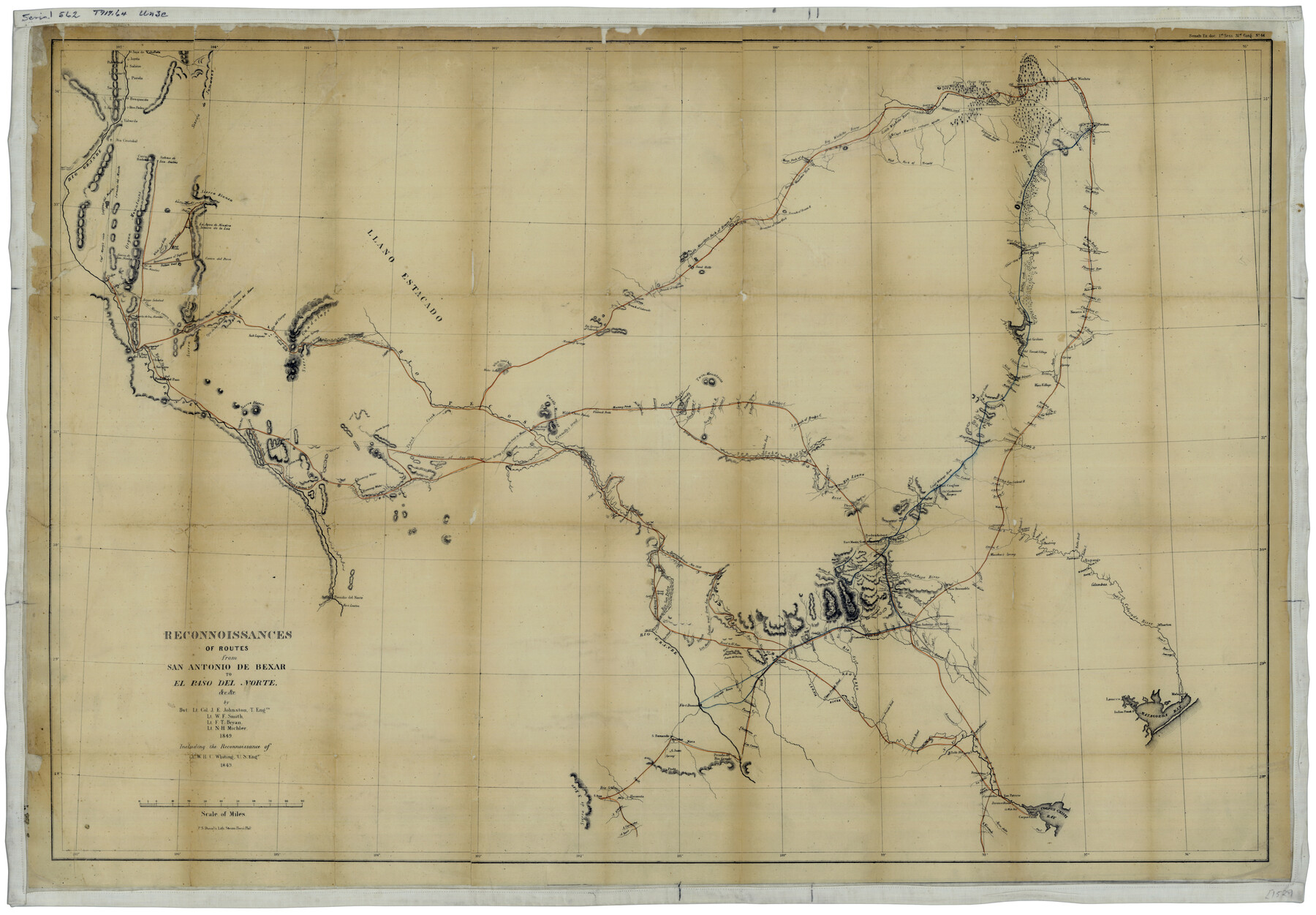
Reconnoissances of Routes from San Antonio de Bexar to El Paso Del Norte
-
Map/Doc
76239
-
Collection
Texas State Library and Archives
-
Object Dates
1849 (Creation Date)
-
People and Organizations
W.H.C. Whiting (Surveyor/Engineer)
J.E. Johnston (Surveyor/Engineer)
W.F. Smith (Surveyor/Engineer)
F.T. Bryan (Surveyor/Engineer)
N.H. Michler (Surveyor/Engineer)
-
Subjects
Military
-
Height x Width
27.5 x 39.6 inches
69.9 x 100.6 cm
-
Comments
Prints available courtesy of the Texas State Library and Archives.
More info can be found here: TSLAC Map 01529
Part of: Texas State Library and Archives
A Map of Louisiana and Mexico

Print $20.00
A Map of Louisiana and Mexico
1820
Size 43.0 x 32.6 inches
Map/Doc 76218
General Highway Map, Hidalgo County, Texas

Print $20.00
General Highway Map, Hidalgo County, Texas
1961
Size 18.1 x 24.9 inches
Map/Doc 79518
General Highway Map, Floyd County, Texas

Print $20.00
General Highway Map, Floyd County, Texas
1940
Size 25.1 x 18.7 inches
Map/Doc 79091
Preliminary Sketch of Galveston Bay Indicating Proposed Sites for Light Houses

Print $20.00
Preliminary Sketch of Galveston Bay Indicating Proposed Sites for Light Houses
1851
Size 20.7 x 18.0 inches
Map/Doc 76215
General Highway Map, Ochiltree County, Texas

Print $20.00
General Highway Map, Ochiltree County, Texas
1961
Size 18.2 x 24.3 inches
Map/Doc 79618
General Highway Map, Cherokee County, Texas

Print $20.00
General Highway Map, Cherokee County, Texas
1961
Size 18.2 x 24.6 inches
Map/Doc 79405
General Highway Map, Comanche County, Texas

Print $20.00
General Highway Map, Comanche County, Texas
1961
Size 24.7 x 18.2 inches
Map/Doc 79419
Official Map of the State of Texas to accompany the Statistical and Descriptive Work, "Resources, Soil and Climate of Texas"

Print $20.00
Official Map of the State of Texas to accompany the Statistical and Descriptive Work, "Resources, Soil and Climate of Texas"
1882
Size 32.3 x 34.4 inches
Map/Doc 76257
General Highway Map, Jack County, Texas

Print $20.00
General Highway Map, Jack County, Texas
1961
Size 18.2 x 24.5 inches
Map/Doc 79532

General Highway Map, Trinity County, Texas

Print $20.00
General Highway Map, Trinity County, Texas
1940
Size 18.4 x 24.9 inches
Map/Doc 79263
General Highway Map, Refugio County, Texas

Print $20.00
General Highway Map, Refugio County, Texas
1961
Size 18.1 x 24.7 inches
Map/Doc 79639
You may also like
Bell County Sketch File 6

Print $4.00
- Digital $50.00
Bell County Sketch File 6
Size 6.3 x 7.7 inches
Map/Doc 14373
Childress County Sketch File 16b

Print $6.00
- Digital $50.00
Childress County Sketch File 16b
1884
Size 12.6 x 8.1 inches
Map/Doc 18305
Tarrant County

Print $20.00
- Digital $50.00
Tarrant County
1857
Size 20.9 x 15.4 inches
Map/Doc 4628
Map of Hays County, Texas

Print $20.00
- Digital $50.00
Map of Hays County, Texas
1880
Size 24.3 x 21.4 inches
Map/Doc 5029
Flight Mission No. CRC-6R, Frame 36, Chambers County

Print $20.00
- Digital $50.00
Flight Mission No. CRC-6R, Frame 36, Chambers County
1956
Size 18.8 x 22.4 inches
Map/Doc 84969
Chambers County Sketch File 27

Print $12.00
- Digital $50.00
Chambers County Sketch File 27
1934
Size 11.3 x 8.8 inches
Map/Doc 17606
Pecos County Rolled Sketch 81

Print $20.00
- Digital $50.00
Pecos County Rolled Sketch 81
1930
Size 35.9 x 25.4 inches
Map/Doc 7240
Dawson County Sketch File 13

Print $2.00
- Digital $50.00
Dawson County Sketch File 13
Size 11.2 x 8.6 inches
Map/Doc 20546
Liberty County Sketch File 52

Print $20.00
- Digital $50.00
Liberty County Sketch File 52
Size 17.5 x 13.5 inches
Map/Doc 11995
Flight Mission No. BRA-7M, Frame 140, Jefferson County

Print $20.00
- Digital $50.00
Flight Mission No. BRA-7M, Frame 140, Jefferson County
1953
Size 18.5 x 22.4 inches
Map/Doc 85534
Cameron County Aerial Photograph Index Sheet 6

Print $20.00
- Digital $50.00
Cameron County Aerial Photograph Index Sheet 6
1955
Size 20.6 x 14.0 inches
Map/Doc 83678
Galveston Bay & Texas Land Company Scrip No. 6086

Print $20.00
- Digital $50.00
Galveston Bay & Texas Land Company Scrip No. 6086
1830
Size 12.7 x 8.2 inches
Map/Doc 96568