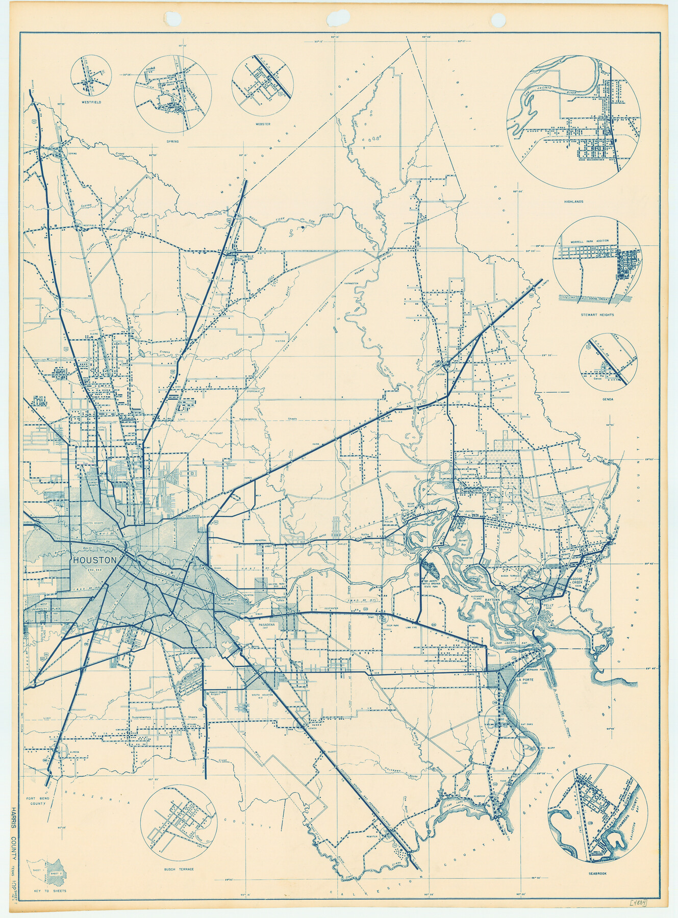
General Highway Map, Harris County, Texas
-
Map/Doc
79116
-
Collection
Texas State Library and Archives
-
Object Dates
1939 (Creation Date)
-
People and Organizations
Texas State Highway Department (Publisher)
-
Counties
Harris
-
Subjects
County
-
Height x Width
25.3 x 18.7 inches
64.3 x 47.5 cm
-
Comments
Prints available courtesy of the Texas State Library and Archives.
More info can be found here: TSLAC Map 04884
Part of: Texas State Library and Archives
General Highway Map, Shelby County, Texas

Print $20.00
General Highway Map, Shelby County, Texas
1940
Size 18.3 x 24.8 inches
Map/Doc 79242
Principal Highways of the Southwest with particular reference to New Mexico, Oklahoma, Texas, Arkansas and Louisiana

Print $20.00
Principal Highways of the Southwest with particular reference to New Mexico, Oklahoma, Texas, Arkansas and Louisiana
1933
Size 24.3 x 18.4 inches
Map/Doc 76302
General Highway Map, McCulloch County, Texas

Print $20.00
General Highway Map, McCulloch County, Texas
1940
Size 24.6 x 18.2 inches
Map/Doc 79190
General Highway Map, Karnes County, Texas

Print $20.00
General Highway Map, Karnes County, Texas
1961
Size 18.1 x 24.6 inches
Map/Doc 79547
Plan of the City of Austin

Print $20.00
Plan of the City of Austin
1853
Size 13.9 x 11.5 inches
Map/Doc 76207
General Highway Map, Delta County, Hopkins County, Texas

Print $20.00
General Highway Map, Delta County, Hopkins County, Texas
1940
Size 25.2 x 18.5 inches
Map/Doc 79073
Stremme General Land Office Drawings, front door

Print $20.00
Stremme General Land Office Drawings, front door
Size 27.4 x 21.9 inches
Map/Doc 79737
A New Map of the United States of America

Print $20.00
A New Map of the United States of America
1856
Size 17.8 x 28.0 inches
Map/Doc 79320
General Highway Map. Detail of Cities and Towns in Val Verde County, Texas [Del Rio and vicinity]
![79695, General Highway Map. Detail of Cities and Towns in Val Verde County, Texas [Del Rio and vicinity], Texas State Library and Archives](https://historictexasmaps.com/wmedia_w700/maps/79695.tif.jpg)
Print $20.00
General Highway Map. Detail of Cities and Towns in Val Verde County, Texas [Del Rio and vicinity]
1961
Size 18.0 x 24.8 inches
Map/Doc 79695
General Highway Map, Lubbock County, Texas

Print $20.00
General Highway Map, Lubbock County, Texas
1961
Size 18.1 x 24.6 inches
Map/Doc 79578
General Highway Map, Hidalgo County, Texas

Print $20.00
General Highway Map, Hidalgo County, Texas
1940
Size 18.4 x 24.7 inches
Map/Doc 79127
General Highway Map, Waller County, Texas

Print $20.00
General Highway Map, Waller County, Texas
1961
Size 24.9 x 18.2 inches
Map/Doc 79700
You may also like
Coryell County Working Sketch 4

Print $20.00
- Digital $50.00
Coryell County Working Sketch 4
1929
Size 23.8 x 18.3 inches
Map/Doc 68211
Panola County, Texas

Print $20.00
- Digital $50.00
Panola County, Texas
1879
Size 18.0 x 19.4 inches
Map/Doc 654
Jefferson County Rolled Sketch 61B

Print $20.00
- Digital $50.00
Jefferson County Rolled Sketch 61B
1928
Size 27.3 x 40.3 inches
Map/Doc 6411
Callahan County Working Sketch 5

Print $20.00
- Digital $50.00
Callahan County Working Sketch 5
1954
Size 24.3 x 33.8 inches
Map/Doc 67887

Oldham County Sketch File 9a

Print $4.00
- Digital $50.00
Oldham County Sketch File 9a
1886
Size 14.2 x 8.7 inches
Map/Doc 33241
Webb County Rolled Sketch 40

Print $20.00
- Digital $50.00
Webb County Rolled Sketch 40
1941
Size 20.6 x 18.4 inches
Map/Doc 8195
Reagan County Working Sketch 5

Print $20.00
- Digital $50.00
Reagan County Working Sketch 5
1924
Size 19.2 x 19.5 inches
Map/Doc 71845
Presidio County Sketch File 105

Print $20.00
- Digital $50.00
Presidio County Sketch File 105
Size 15.6 x 42.6 inches
Map/Doc 11726
Titus County Sketch File 2

Print $4.00
- Digital $50.00
Titus County Sketch File 2
Size 8.2 x 10.1 inches
Map/Doc 38132
Sterling County Sketch File 24

Print $6.00
- Digital $50.00
Sterling County Sketch File 24
1955
Size 11.1 x 8.5 inches
Map/Doc 37189
General Highway Map, Runnels County, Texas

Print $20.00
General Highway Map, Runnels County, Texas
1961
Size 24.6 x 18.2 inches
Map/Doc 79642