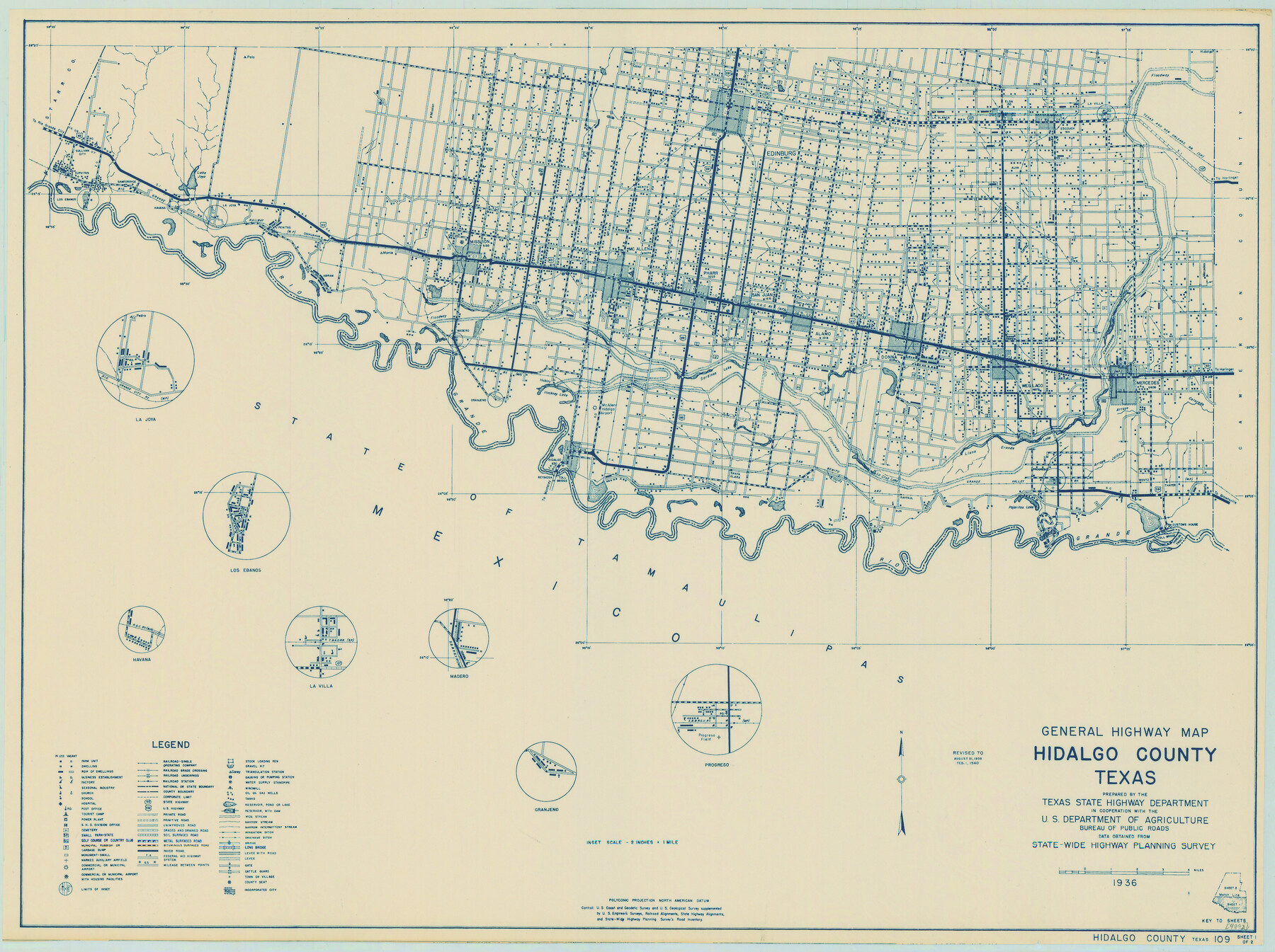
General Highway Map, Hidalgo County, Texas
-
Map/Doc
79127
-
Collection
Texas State Library and Archives
-
Object Dates
1940 (Creation Date)
-
People and Organizations
Texas State Highway Department (Publisher)
-
Counties
Hidalgo
-
Subjects
County
-
Height x Width
18.4 x 24.7 inches
46.7 x 62.7 cm
-
Comments
Prints available courtesy of the Texas State Library and Archives.
More info can be found here: TSLAC Map 04892
Part of: Texas State Library and Archives
General Highway Map, Live Oak County, Texas

Print $20.00
General Highway Map, Live Oak County, Texas
1961
Size 18.2 x 24.8 inches
Map/Doc 79574
General Highway Map, Hamilton County, Texas

Print $20.00
General Highway Map, Hamilton County, Texas
1961
Size 18.1 x 24.9 inches
Map/Doc 79496
That Part of Disturnell's Treaty Map in the Vicinity of the Rio Grande and Southern Boundary of New Mexico

Print $20.00
That Part of Disturnell's Treaty Map in the Vicinity of the Rio Grande and Southern Boundary of New Mexico
1851
Size 10.7 x 12.9 inches
Map/Doc 76285
Central America Including Texas, California, and the Northern States Mexico

Print $20.00
Central America Including Texas, California, and the Northern States Mexico
1842
Size 13.8 x 16.7 inches
Map/Doc 76273
Official Map of the State of Texas to accompany the Statistical and Descriptive Work, "Resources, Soil and Climate of Texas"

Print $20.00
Official Map of the State of Texas to accompany the Statistical and Descriptive Work, "Resources, Soil and Climate of Texas"
1882
Size 32.3 x 34.4 inches
Map/Doc 76257
General Highway Map, Frio County, Texas

Print $20.00
General Highway Map, Frio County, Texas
1940
Size 18.4 x 24.9 inches
Map/Doc 79095
A.R. Roessler's Latest Map of the State of Texas Exhibiting Mineral and Agricultural Districts, Post Offices and Mailroutes, Railroads projected and finished, Timber, Prairie, Swamp Lands, etc. etc. etc.

Print $20.00
A.R. Roessler's Latest Map of the State of Texas Exhibiting Mineral and Agricultural Districts, Post Offices and Mailroutes, Railroads projected and finished, Timber, Prairie, Swamp Lands, etc. etc. etc.
1874
Size 39.7 x 46.8 inches
Map/Doc 76254
General Highway Map, Washington County, Texas

Print $20.00
General Highway Map, Washington County, Texas
1961
Size 18.1 x 24.7 inches
Map/Doc 79703
General Highway Map, Galveston County, Texas

Print $20.00
General Highway Map, Galveston County, Texas
1961
Size 18.2 x 24.6 inches
Map/Doc 79476
General Highway Map, Edwards County, Real County, Texas

Print $20.00
General Highway Map, Edwards County, Real County, Texas
1961
Size 18.1 x 24.7 inches
Map/Doc 79452
Description of Best Route from Austin to San Antonio, Texas

Print $20.00
Description of Best Route from Austin to San Antonio, Texas
1865
Size 12.9 x 13.1 inches
Map/Doc 79296
General Highway Map, Brazoria County, Texas

Print $20.00
General Highway Map, Brazoria County, Texas
1961
Size 24.9 x 18.1 inches
Map/Doc 79383
You may also like
Harris County Rolled Sketch 85

Print $20.00
- Digital $50.00
Harris County Rolled Sketch 85
1968
Size 22.0 x 32.0 inches
Map/Doc 6119
Working Sketch in Dickens and Crosby Cos.

Print $20.00
- Digital $50.00
Working Sketch in Dickens and Crosby Cos.
1910
Size 36.1 x 24.8 inches
Map/Doc 10771
[Sketch of Surveys in] Tom Green County, [Texas]
![471, [Sketch of Surveys in] Tom Green County, [Texas]](https://historictexasmaps.com/wmedia_w700/maps/0471.tif.jpg)
Print $20.00
- Digital $50.00
[Sketch of Surveys in] Tom Green County, [Texas]
1882
Size 14.1 x 20.3 inches
Map/Doc 471
Gaines County Working Sketch 14

Print $40.00
- Digital $50.00
Gaines County Working Sketch 14
1957
Size 62.3 x 31.7 inches
Map/Doc 69314
[Strickland Survey Sketch Showing Abercrombie Corner, Exhibit C]
![91370, [Strickland Survey Sketch Showing Abercrombie Corner, Exhibit C], Twichell Survey Records](https://historictexasmaps.com/wmedia_w700/maps/91370-1.tif.jpg)
Print $20.00
- Digital $50.00
[Strickland Survey Sketch Showing Abercrombie Corner, Exhibit C]
Size 25.3 x 19.1 inches
Map/Doc 91370
Crosby County Boundary File 5a

Print $60.00
- Digital $50.00
Crosby County Boundary File 5a
Size 8.0 x 35.4 inches
Map/Doc 52044
Gaines County

Print $40.00
- Digital $50.00
Gaines County
1902
Size 38.9 x 49.7 inches
Map/Doc 66832
Lamar County Working Sketch 6

Print $20.00
- Digital $50.00
Lamar County Working Sketch 6
1964
Size 37.7 x 26.1 inches
Map/Doc 70267
Nolan County Sketch File 10

Print $6.00
- Digital $50.00
Nolan County Sketch File 10
1902
Size 14.2 x 9.0 inches
Map/Doc 32484
Flight Mission No. CRC-3R, Frame 167, Chambers County

Print $20.00
- Digital $50.00
Flight Mission No. CRC-3R, Frame 167, Chambers County
1956
Size 18.7 x 22.3 inches
Map/Doc 84849
Pecos County Rolled Sketch 175

Print $20.00
- Digital $50.00
Pecos County Rolled Sketch 175
Size 21.2 x 26.2 inches
Map/Doc 7295
Kaufman County

Print $20.00
- Digital $50.00
Kaufman County
1942
Size 46.6 x 38.2 inches
Map/Doc 1871