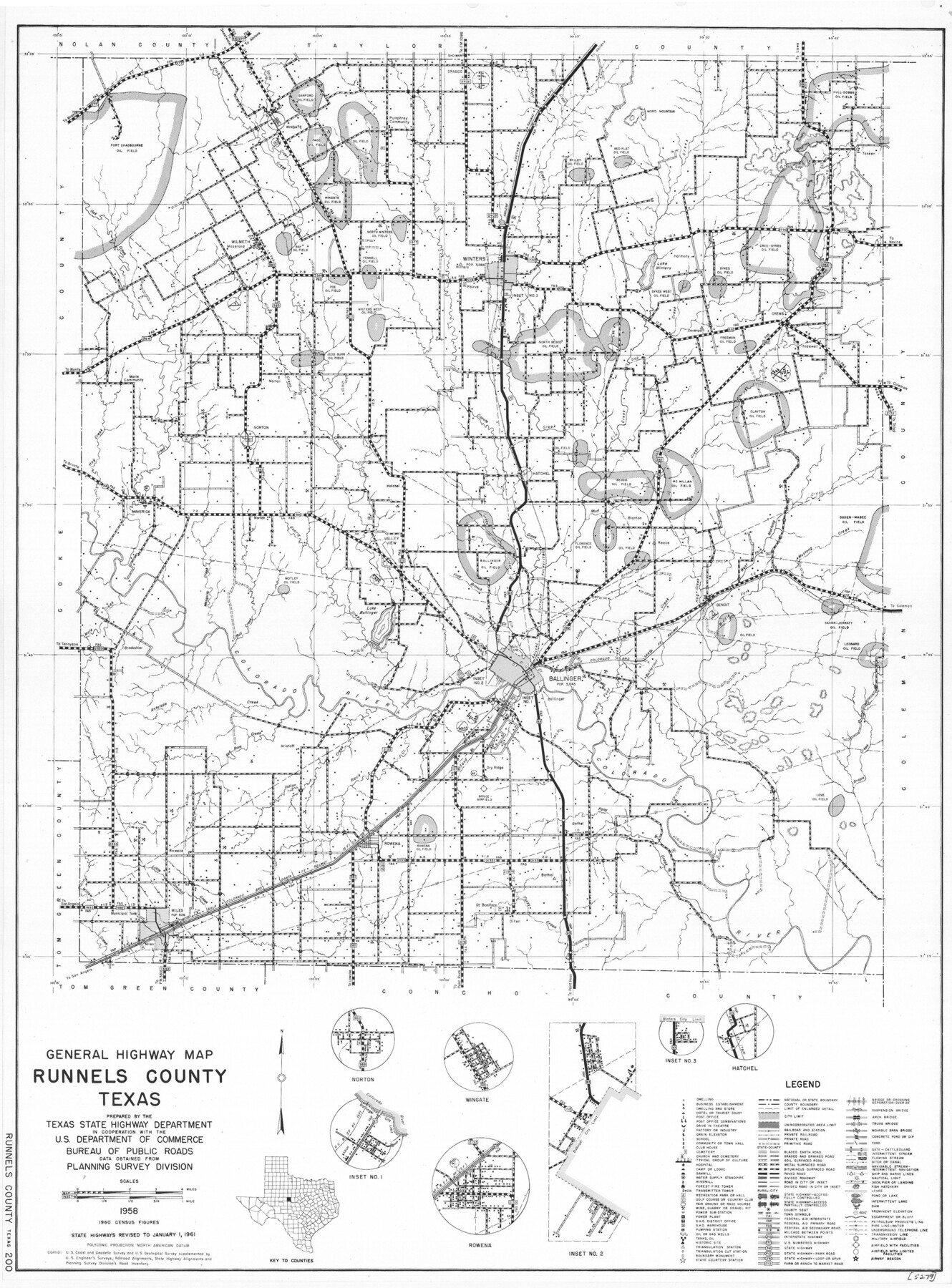
General Highway Map, Runnels County, Texas
-
Map/Doc
79642
-
Collection
Texas State Library and Archives
-
Object Dates
1961 (Creation Date)
-
People and Organizations
Texas State Highway Department (Publisher)
-
Counties
Runnels
-
Subjects
County
-
Height x Width
24.6 x 18.2 inches
62.5 x 46.2 cm
-
Comments
Prints available courtesy of the Texas State Library and Archives.
More info can be found here: TSLAC Map 05279
Part of: Texas State Library and Archives
Map of that Portion of the Boundary Between the United States and Mexico from the Pacific Coast to the Junction of the Gila and Colorado Rivers

Print $40.00
Map of that Portion of the Boundary Between the United States and Mexico from the Pacific Coast to the Junction of the Gila and Colorado Rivers
1854
Size 23.9 x 51.4 inches
Map/Doc 79323
General Highway Map, Atascosa County, Texas

Print $20.00
General Highway Map, Atascosa County, Texas
1961
Size 18.3 x 24.9 inches
Map/Doc 79356
General Highway Map, Wheeler County, Texas

Print $20.00
General Highway Map, Wheeler County, Texas
1940
Size 18.4 x 24.8 inches
Map/Doc 79276
General Highway Map. Detail of Cities and Towns in Harris County, Texas

Print $20.00
General Highway Map. Detail of Cities and Towns in Harris County, Texas
1939
Size 18.3 x 24.7 inches
Map/Doc 79120
General Highway Map, Jackson County, Texas

Print $20.00
General Highway Map, Jackson County, Texas
1940
Size 18.3 x 24.8 inches
Map/Doc 79140
General Highway Map. Detail of Cities and Towns in Orange County, Texas [Orange and vicinity]
![79622, General Highway Map. Detail of Cities and Towns in Orange County, Texas [Orange and vicinity], Texas State Library and Archives](https://historictexasmaps.com/wmedia_w700/maps/79622.tif.jpg)
Print $20.00
General Highway Map. Detail of Cities and Towns in Orange County, Texas [Orange and vicinity]
1961
Size 18.1 x 24.4 inches
Map/Doc 79622
General Highway Map, Kerr County, Texas

Print $20.00
General Highway Map, Kerr County, Texas
1961
Size 24.6 x 18.2 inches
Map/Doc 79552
Correct Map of the Railway and Steamship Lines operated by the Southern Pacific Company

Print $20.00
Correct Map of the Railway and Steamship Lines operated by the Southern Pacific Company
1894
Size 17.0 x 40.1 inches
Map/Doc 79333
General Highway Map. Detail of Cities and Towns in Austin County, Texas [Sealy and Bellville, etc.]
![79358, General Highway Map. Detail of Cities and Towns in Austin County, Texas [Sealy and Bellville, etc.], Texas State Library and Archives](https://historictexasmaps.com/wmedia_w700/maps/79358.tif.jpg)
Print $20.00
General Highway Map. Detail of Cities and Towns in Austin County, Texas [Sealy and Bellville, etc.]
1961
Size 18.2 x 25.0 inches
Map/Doc 79358
Map of the Texas and Pacific Railway and Connections

Print $20.00
Map of the Texas and Pacific Railway and Connections
1897
Size 17.7 x 36.1 inches
Map/Doc 76298
Map Showing Colonel A.W. Doniphan's Route through the States of New Mexico, Chihuahua and Coahuila

Print $20.00
Map Showing Colonel A.W. Doniphan's Route through the States of New Mexico, Chihuahua and Coahuila
1847
Size 16.9 x 14.0 inches
Map/Doc 79729
General Highway Map, Fisher County, Texas

Print $20.00
General Highway Map, Fisher County, Texas
1961
Size 18.1 x 24.7 inches
Map/Doc 79466
You may also like
Ellis County Sketch File 21

Print $24.00
- Digital $50.00
Ellis County Sketch File 21
1879
Size 7.6 x 12.4 inches
Map/Doc 21878
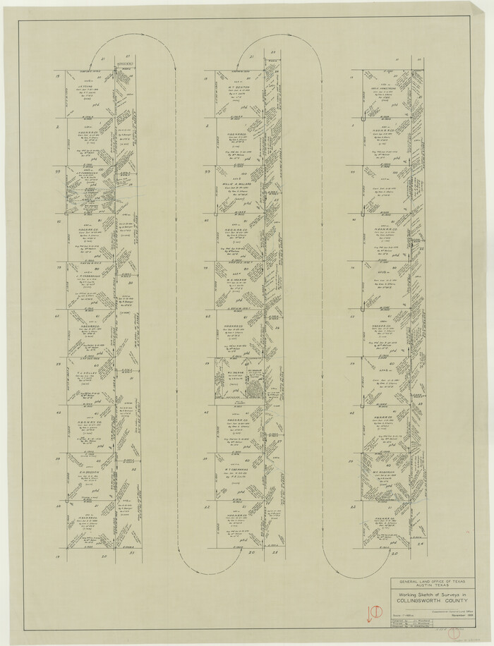
Collingsworth County Working Sketch 1
Print $20.00
- Digital $50.00
Collingsworth County Working Sketch 1
1939
Size 43.0 x 32.8 inches
Map/Doc 68089
[SW Corner of Yoakum County]
![92443, [SW Corner of Yoakum County], Twichell Survey Records](https://historictexasmaps.com/wmedia_w700/maps/92443-1.tif.jpg)
Print $20.00
- Digital $50.00
[SW Corner of Yoakum County]
Size 24.2 x 18.5 inches
Map/Doc 92443
Parker County Boundary File 3a

Print $34.00
- Digital $50.00
Parker County Boundary File 3a
Size 11.2 x 8.8 inches
Map/Doc 57840
[H. & T. C. Block 47]
![91190, [H. & T. C. Block 47], Twichell Survey Records](https://historictexasmaps.com/wmedia_w700/maps/91190-1.tif.jpg)
Print $20.00
- Digital $50.00
[H. & T. C. Block 47]
1874
Size 21.1 x 12.2 inches
Map/Doc 91190
Pecos County Sketch File 23

Print $20.00
- Digital $50.00
Pecos County Sketch File 23
1886
Size 18.0 x 18.0 inches
Map/Doc 12162
Milam County Working Sketch 8

Print $20.00
- Digital $50.00
Milam County Working Sketch 8
1970
Size 27.1 x 30.7 inches
Map/Doc 71023
Presidio County Working Sketch 1

Print $20.00
- Digital $50.00
Presidio County Working Sketch 1
Size 37.4 x 20.4 inches
Map/Doc 71675
Harris County Working Sketch 76

Print $20.00
- Digital $50.00
Harris County Working Sketch 76
1966
Size 32.2 x 24.2 inches
Map/Doc 65968
McLean, Texas Section 22, Block R

Print $20.00
- Digital $50.00
McLean, Texas Section 22, Block R
Size 16.0 x 16.1 inches
Map/Doc 90721
North Portion of Lavaca Bay and Vicinity, showing Subdivision for Mineral Development

Print $20.00
- Digital $50.00
North Portion of Lavaca Bay and Vicinity, showing Subdivision for Mineral Development
1946
Size 33.8 x 37.1 inches
Map/Doc 1911
Crane County Working Sketch 4

Print $20.00
- Digital $50.00
Crane County Working Sketch 4
Size 24.5 x 18.2 inches
Map/Doc 68281