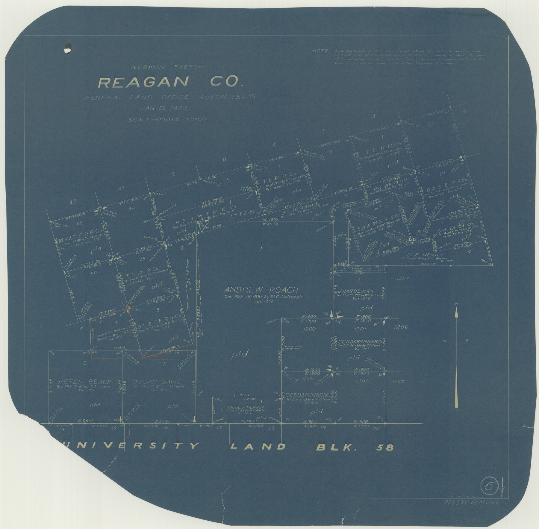
Reagan County Working Sketch 5
-
Map/Doc
71845
-
Collection
General Map Collection
-
Object Dates
1/22/1924 (Creation Date)
-
People and Organizations
J. Bascom Giles (Draftsman)
-
Counties
Reagan
-
Subjects
Surveying Working Sketch
-
Height x Width
19.2 x 19.5 inches
48.8 x 49.5 cm
-
Scale
1" = 1000 varas
Part of: General Map Collection
Harris County Working Sketch 127

Print $20.00
- Digital $50.00
Harris County Working Sketch 127
1996
Size 20.7 x 26.0 inches
Map/Doc 66019
Montgomery County Sketch File 35

Print $8.00
- Digital $50.00
Montgomery County Sketch File 35
1953
Size 14.1 x 8.9 inches
Map/Doc 31908
Hudspeth County Working Sketch 44

Print $20.00
- Digital $50.00
Hudspeth County Working Sketch 44
1982
Size 25.5 x 22.2 inches
Map/Doc 66329
Presidio County Working Sketch 5

Print $20.00
- Digital $50.00
Presidio County Working Sketch 5
1917
Size 14.0 x 17.5 inches
Map/Doc 71679
Crockett County Rolled Sketch 88D

Print $40.00
- Digital $50.00
Crockett County Rolled Sketch 88D
Size 43.2 x 52.0 inches
Map/Doc 8729
Nacogdoches County Sketch File 7

Print $6.00
- Digital $50.00
Nacogdoches County Sketch File 7
1875
Size 10.4 x 15.0 inches
Map/Doc 32250
Map of Concho County

Print $20.00
- Digital $50.00
Map of Concho County
1897
Size 47.0 x 39.5 inches
Map/Doc 4733
Plano del Distrilo de Rio Grande Estado de Coahuila

Print $20.00
- Digital $50.00
Plano del Distrilo de Rio Grande Estado de Coahuila
1906
Size 30.3 x 31.5 inches
Map/Doc 1941
Val Verde County Working Sketch 53

Print $20.00
- Digital $50.00
Val Verde County Working Sketch 53
1956
Size 42.8 x 47.7 inches
Map/Doc 72188
Calhoun County NRC Article 33.136 Sketch 6

Print $24.00
- Digital $50.00
Calhoun County NRC Article 33.136 Sketch 6
2014
Size 18.0 x 24.0 inches
Map/Doc 94462
Upton County Working Sketch 26

Print $20.00
- Digital $50.00
Upton County Working Sketch 26
1953
Size 29.5 x 17.6 inches
Map/Doc 69522
Winkler County Rolled Sketch 14

Print $20.00
- Digital $50.00
Winkler County Rolled Sketch 14
Size 25.9 x 38.4 inches
Map/Doc 8275
You may also like
Flight Mission No. CLL-3N, Frame 44, Willacy County

Print $20.00
- Digital $50.00
Flight Mission No. CLL-3N, Frame 44, Willacy County
1954
Size 18.4 x 22.0 inches
Map/Doc 87102
Clay County Working Sketch 2

Print $20.00
- Digital $50.00
Clay County Working Sketch 2
1907
Size 26.5 x 16.2 inches
Map/Doc 68025
Calhoun County NRC Article 33.136 Sketch 3

Print $40.00
- Digital $50.00
Calhoun County NRC Article 33.136 Sketch 3
2000
Size 24.4 x 36.5 inches
Map/Doc 81914
Right of Way and Track Map, the Missouri, Kansas & Texas Ry. Of Texas operated by the Missouri, Kansas & Texas Ry. Of Texas, Houston Division

Print $40.00
- Digital $50.00
Right of Way and Track Map, the Missouri, Kansas & Texas Ry. Of Texas operated by the Missouri, Kansas & Texas Ry. Of Texas, Houston Division
1918
Size 24.7 x 73.8 inches
Map/Doc 64565
Harrison County

Print $20.00
- Digital $50.00
Harrison County
1857
Size 20.3 x 21.0 inches
Map/Doc 1116
Flight Mission No. CGI-4N, Frame 162, Cameron County

Print $20.00
- Digital $50.00
Flight Mission No. CGI-4N, Frame 162, Cameron County
1955
Size 18.7 x 22.5 inches
Map/Doc 84670
Kimble County Working Sketch 42

Print $20.00
- Digital $50.00
Kimble County Working Sketch 42
1949
Size 40.5 x 40.0 inches
Map/Doc 70110
Andrews County Rolled Sketch 23

Print $40.00
- Digital $50.00
Andrews County Rolled Sketch 23
1946
Size 78.0 x 13.7 inches
Map/Doc 8396
Erath County Working Sketch 16

Print $20.00
- Digital $50.00
Erath County Working Sketch 16
1961
Size 20.9 x 26.5 inches
Map/Doc 69097
Jefferson County Working Sketch 37

Print $40.00
- Digital $50.00
Jefferson County Working Sketch 37
1982
Size 49.9 x 36.6 inches
Map/Doc 66581
Bee County Working Sketch 15

Print $20.00
- Digital $50.00
Bee County Working Sketch 15
1974
Size 20.4 x 27.9 inches
Map/Doc 67265
[Sketch Showing Wm. T. Brewer, John R. Taylor, Wm. F. Butler, Timothy DeVore, L. M. Thorn and adjoining surveys]
![90231, [Sketch Showing Wm. T. Brewer, John R. Taylor, Wm. F. Butler, Timothy DeVore, L. M. Thorn and adjoining surveys], Twichell Survey Records](https://historictexasmaps.com/wmedia_w700/maps/90231-1.tif.jpg)
Print $20.00
- Digital $50.00
[Sketch Showing Wm. T. Brewer, John R. Taylor, Wm. F. Butler, Timothy DeVore, L. M. Thorn and adjoining surveys]
Size 27.2 x 19.4 inches
Map/Doc 90231