Oldham County Sketch File 9a
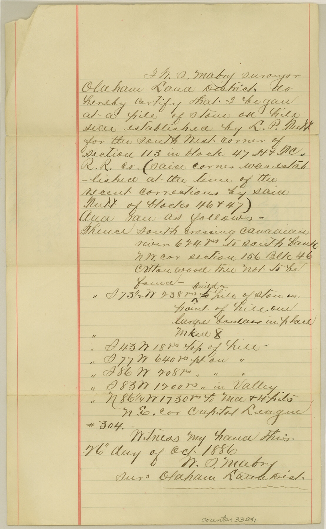
[Surveyor's explanation regarding connecting line run from the southwest corner of section 113, Block 47 with Capitol League 304]
-
Map/Doc
33241
-
Collection
General Map Collection
-
Object Dates
10/26/1886 (Creation Date)
11/4/1886 (File Date)
-
People and Organizations
W.S. Mabry (Surveyor/Engineer)
L.P. Tutt (Surveyor/Engineer)
-
Counties
Oldham
-
Subjects
Surveying Sketch File
-
Height x Width
14.2 x 8.7 inches
36.1 x 22.1 cm
-
Medium
paper, manuscript
-
Comments
For accompanying sketch, see Oldham County Sketch File 9 (12112).
Related maps
Oldham County Sketch File 9

Print $20.00
- Digital $50.00
Oldham County Sketch File 9
1886
Size 18.4 x 26.1 inches
Map/Doc 12112
Part of: General Map Collection
Wise County Sketch File 26b

Print $20.00
- Digital $50.00
Wise County Sketch File 26b
1855
Size 13.3 x 19.9 inches
Map/Doc 12700
[Map of Tom Green County]
![4085, [Map of Tom Green County], General Map Collection](https://historictexasmaps.com/wmedia_w700/maps/4085-2.tif.jpg)
Print $20.00
- Digital $50.00
[Map of Tom Green County]
Size 23.9 x 36.5 inches
Map/Doc 4085
Crane County Sketch File 26

Print $10.00
- Digital $50.00
Crane County Sketch File 26
1939
Size 11.5 x 9.0 inches
Map/Doc 19598
Flight Mission No. DQO-8K, Frame 84, Galveston County

Print $20.00
- Digital $50.00
Flight Mission No. DQO-8K, Frame 84, Galveston County
1952
Size 18.6 x 22.5 inches
Map/Doc 85186
Anderson County Working Sketch 21

Print $20.00
- Digital $50.00
Anderson County Working Sketch 21
1954
Size 24.9 x 33.9 inches
Map/Doc 67021
Flight Mission No. DAG-21K, Frame 131, Matagorda County

Print $20.00
- Digital $50.00
Flight Mission No. DAG-21K, Frame 131, Matagorda County
1952
Size 18.6 x 22.4 inches
Map/Doc 86457
Travis County State Real Property Sketch 16

Print $20.00
- Digital $50.00
Travis County State Real Property Sketch 16
2009
Size 48.1 x 36.1 inches
Map/Doc 90086
Comal County Working Sketch 2

Print $20.00
- Digital $50.00
Comal County Working Sketch 2
1940
Size 19.8 x 20.9 inches
Map/Doc 68168
San Luis Pass to East Matagorda Bay

Print $20.00
- Digital $50.00
San Luis Pass to East Matagorda Bay
1976
Size 35.1 x 46.7 inches
Map/Doc 69969
Clay County Working Sketch 6

Print $20.00
- Digital $50.00
Clay County Working Sketch 6
1923
Size 30.0 x 24.1 inches
Map/Doc 68029
Pecos County Sketch File 19

Print $4.00
- Digital $50.00
Pecos County Sketch File 19
Size 14.2 x 8.8 inches
Map/Doc 33668
Bosque County Sketch File 8

Print $4.00
- Digital $50.00
Bosque County Sketch File 8
1858
Size 12.4 x 8.2 inches
Map/Doc 14752
You may also like
Flight Mission No. BRE-1P, Frame 79, Nueces County

Print $20.00
- Digital $50.00
Flight Mission No. BRE-1P, Frame 79, Nueces County
1956
Size 18.4 x 22.2 inches
Map/Doc 86661
Young County Boundary File 98

Print $12.00
- Digital $50.00
Young County Boundary File 98
Size 8.8 x 7.5 inches
Map/Doc 60205
Sketch of Sabine Lake and Pass

Print $20.00
- Digital $50.00
Sketch of Sabine Lake and Pass
1840
Size 24.8 x 18.2 inches
Map/Doc 72725
Cochran County Boundary File 7

Print $6.00
- Digital $50.00
Cochran County Boundary File 7
Size 14.0 x 9.1 inches
Map/Doc 51567
Map of the Missouri Pacific and St. Louis, Iron Mountain and Southern Railways and Connections

Print $20.00
- Digital $50.00
Map of the Missouri Pacific and St. Louis, Iron Mountain and Southern Railways and Connections
1895
Size 17.8 x 31.8 inches
Map/Doc 95790
Travis County Working Sketch 10

Print $20.00
- Digital $50.00
Travis County Working Sketch 10
1918
Size 24.7 x 16.3 inches
Map/Doc 69394
South Sulphur River, Harpers Crossing Sheet

Print $20.00
- Digital $50.00
South Sulphur River, Harpers Crossing Sheet
1925
Size 42.2 x 29.2 inches
Map/Doc 65169
Hutchinson County Working Sketch 18

Print $20.00
- Digital $50.00
Hutchinson County Working Sketch 18
1956
Size 31.4 x 18.3 inches
Map/Doc 66378
[Triangulation Net of Part of Texas. Travis County to Red River]
![3101, [Triangulation Net of Part of Texas. Travis County to Red River], General Map Collection](https://historictexasmaps.com/wmedia_w700/maps/3101.tif.jpg)
Print $20.00
- Digital $50.00
[Triangulation Net of Part of Texas. Travis County to Red River]
1928
Size 28.2 x 33.9 inches
Map/Doc 3101
This is a true copy of Peck's field book No. 7 pages 28 to 35, except classification of land

Print $40.00
- Digital $50.00
This is a true copy of Peck's field book No. 7 pages 28 to 35, except classification of land
Size 5.7 x 68.2 inches
Map/Doc 89728
Andrews County Sketch File 9

Print $8.00
- Digital $50.00
Andrews County Sketch File 9
1949
Size 14.2 x 8.6 inches
Map/Doc 12853
Starr County Working Sketch 15

Print $20.00
- Digital $50.00
Starr County Working Sketch 15
1971
Size 34.4 x 37.6 inches
Map/Doc 63931