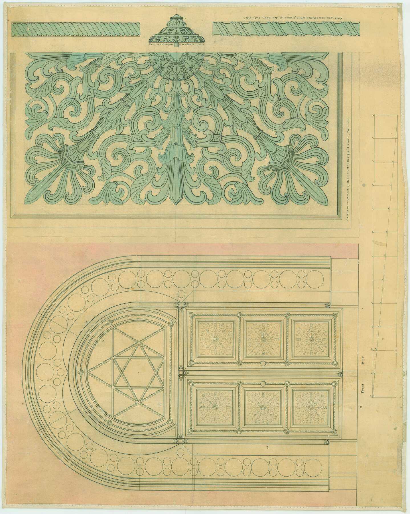
Stremme General Land Office Drawings, front door
-
Map/Doc
79737
-
Collection
Texas State Library and Archives
-
Subjects
Curiosities
-
Height x Width
27.4 x 21.9 inches
69.6 x 55.6 cm
-
Comments
Prints available from the GLO courtesy of the Texas State Library and Archives.
Part of: Texas State Library and Archives
Preliminary Chart of the Entrance to Matagorda Bay, Texas

Print $20.00
Preliminary Chart of the Entrance to Matagorda Bay, Texas
1857
Size 20.2 x 32.9 inches
Map/Doc 76247
General Highway Map, Matagorda County, Texas

Print $20.00
General Highway Map, Matagorda County, Texas
1939
Size 24.7 x 18.3 inches
Map/Doc 79187
Map of Texas and Parts of Adjoining Territories

Print $20.00
Map of Texas and Parts of Adjoining Territories
1899
Size 33.7 x 36.0 inches
Map/Doc 79304
General Highway Map, Victoria County, Texas

Print $20.00
General Highway Map, Victoria County, Texas
1940
Size 24.8 x 18.5 inches
Map/Doc 79268
General Highway Map, Scurry County, Texas

Print $20.00
General Highway Map, Scurry County, Texas
1940
Size 18.4 x 24.8 inches
Map/Doc 79240
General Highway Map, Hutchinson County, Texas

Print $20.00
General Highway Map, Hutchinson County, Texas
1940
Size 18.3 x 24.8 inches
Map/Doc 79137
General Highway Map, Terry County, Texas

Print $20.00
General Highway Map, Terry County, Texas
1961
Size 18.1 x 24.9 inches
Map/Doc 79675
General Highway Map, Parker County, Texas

Print $20.00
General Highway Map, Parker County, Texas
1961
Size 18.3 x 24.5 inches
Map/Doc 79625
General Highway Map, Matagorda County, Texas

Print $20.00
General Highway Map, Matagorda County, Texas
1939
Size 24.6 x 18.4 inches
Map/Doc 79188
Gulf Coast of the United States, Key West to Rio Grande

Print $40.00
Gulf Coast of the United States, Key West to Rio Grande
1863
Size 30.2 x 53.5 inches
Map/Doc 79335
General Highway Map. Detail of Cities and Towns in Gray County, Texas. [Pampa and vicinity]
![79484, General Highway Map. Detail of Cities and Towns in Gray County, Texas. [Pampa and vicinity], Texas State Library and Archives](https://historictexasmaps.com/wmedia_w700/maps/79484.tif.jpg)
Print $20.00
General Highway Map. Detail of Cities and Towns in Gray County, Texas. [Pampa and vicinity]
1961
Size 24.7 x 18.1 inches
Map/Doc 79484
Reconnaissance of Aransas Pass, Texas

Print $20.00
Reconnaissance of Aransas Pass, Texas
1853
Size 14.9 x 12.4 inches
Map/Doc 76250
You may also like
[Block Y and vicinity]
![91177, [Block Y and vicinity], Twichell Survey Records](https://historictexasmaps.com/wmedia_w700/maps/91177-1.tif.jpg)
Print $20.00
- Digital $50.00
[Block Y and vicinity]
Size 17.7 x 14.6 inches
Map/Doc 91177
Flight Mission No. 29300074, Harris County

Print $20.00
- Digital $50.00
Flight Mission No. 29300074, Harris County
1985
Size 10.4 x 10.4 inches
Map/Doc 85286
Hockley County Working Sketch 3

Print $20.00
- Digital $50.00
Hockley County Working Sketch 3
1962
Size 35.4 x 22.0 inches
Map/Doc 66193
General Highway Map, Smith County, Texas

Print $20.00
General Highway Map, Smith County, Texas
1961
Size 25.1 x 18.3 inches
Map/Doc 79654
Falls County Sketch File 5

Print $9.00
- Digital $50.00
Falls County Sketch File 5
1857
Size 12.5 x 8.7 inches
Map/Doc 22337
Newton County Rolled Sketch 23
Print $20.00
- Digital $50.00
Newton County Rolled Sketch 23
1893
Size 22.7 x 18.5 inches
Map/Doc 6850
Map No. 1 - Rio Bravo del Norte section of boundary between the United States & Mexico agreed upon by the Joint Commission under the Treaty of Guadalupe Hidalgo

Print $20.00
- Digital $50.00
Map No. 1 - Rio Bravo del Norte section of boundary between the United States & Mexico agreed upon by the Joint Commission under the Treaty of Guadalupe Hidalgo
1852
Size 18.3 x 27.0 inches
Map/Doc 72863
Ellwood Farms Subdivision Number 2 of the Spade Ranch Lamb and Hale Counties, Texas

Print $20.00
- Digital $50.00
Ellwood Farms Subdivision Number 2 of the Spade Ranch Lamb and Hale Counties, Texas
Size 20.9 x 29.1 inches
Map/Doc 92173
McLennan County Sketch File 41

Print $44.00
- Digital $50.00
McLennan County Sketch File 41
1963
Size 11.1 x 8.6 inches
Map/Doc 31319
Flight Mission No. DCL-4C, Frame 69, Kenedy County

Print $20.00
- Digital $50.00
Flight Mission No. DCL-4C, Frame 69, Kenedy County
1943
Size 18.7 x 22.3 inches
Map/Doc 85814
Liberty County Sketch File 52

Print $20.00
- Digital $50.00
Liberty County Sketch File 52
Size 17.5 x 13.5 inches
Map/Doc 11995
Polk County Working Sketch 31

Print $20.00
- Digital $50.00
Polk County Working Sketch 31
1960
Size 18.2 x 24.4 inches
Map/Doc 71647