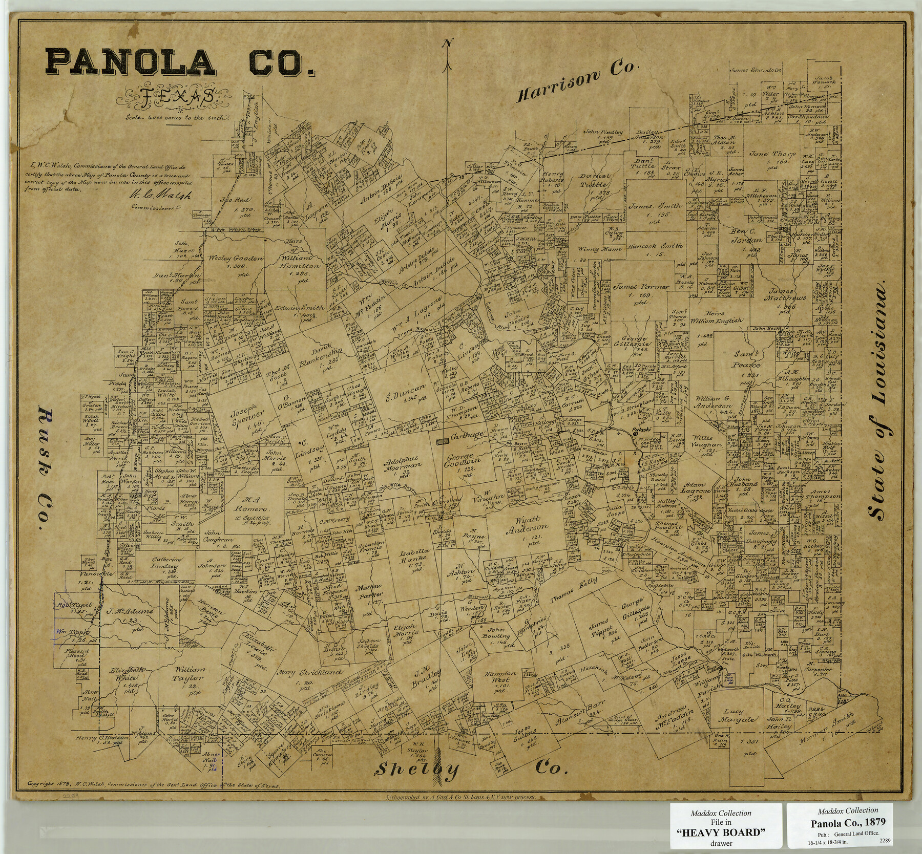
Panola County, Texas
- 
                          Map/Doc
654
 - 
                            Collection
Maddox Collection
 - 
                            Object Dates
1879 (Creation Date)
1879 (Copyright Date)
 - 
                            People and Organizations
General Land Office (Publisher)
W.C. Walsh (GLO Commissioner)
August Gast & Co. (Lithographer)
 - 
                            Counties
Panola Shelby
 - 
                            Subjects
County
 - 
                            Height x Width
18.0 x 19.4 inches
45.7 x 49.3 cm
 - 
                            Medium
paper, etching/engraving/lithograph
 - 
                            Scale
1:4000
 - 
                            Comments
Conservation funded in 2002 with donations from Panola County Citizens
 - 
                            Features
Caddo Creek
Cane Creek
Jacksons Creek
Martin's Creek
Irons Bayou
Sabine River
Socagee Bayou
Pulaski
Carthage
Six Mile Bayou
Mill Creek
Murvall's Bayou
Trammel's Trace
Taylors Creek
Wilkersons Creek
 
Part of: Maddox Collection
            [Mary L. Williams or Lydia Glasgow Survey, Bastrop County, Texas]


                                            Print $3.00                    
                                             -                         Digital $50.00                                    
                [Mary L. Williams or Lydia Glasgow Survey, Bastrop County, Texas]
Size 11.9 x 15.6 inches
                                Map/Doc 572
            
            Map of Survey 10, Block 1, D.B. Gardner


                                            Print $20.00                    
                                             -                         Digital $50.00                                    
                Map of Survey 10, Block 1, D.B. Gardner
1915
Size 16.1 x 18.7 inches
                                Map/Doc 10764
            
            Foard County, Texas


                                            Print $20.00                    
                                             -                         Digital $50.00                                    
                Foard County, Texas
1891
Size 20.6 x 24.5 inches
                                Map/Doc 4338
            
            Map of Blanco County, Texas


                                            Print $20.00                    
                                             -                         Digital $50.00                                    
                Map of Blanco County, Texas
1880
Size 28.5 x 20.1 inches
                                Map/Doc 406
            
            Map of Duval County, Texas


                                            Print $20.00                    
                                             -                         Digital $50.00                                    
                Map of Duval County, Texas
1880
Size 29.8 x 22.6 inches
                                Map/Doc 712
            
            [Sketch of F.R. Lehmann surveys on the Rio Grande]


                                            Print $20.00                    
                                             -                         Digital $50.00                                    
                [Sketch of F.R. Lehmann surveys on the Rio Grande]
Size 14.7 x 16.8 inches
                                Map/Doc 554
            
            Sketch from the map of Bailey Co.


                                            Print $2.00                    
                                             -                         Digital $50.00                                    
                Sketch from the map of Bailey Co.
Size 8.4 x 7.6 inches
                                Map/Doc 464
            
            Hansford County, Texas


                                            Print $20.00                    
                                             -                         Digital $50.00                                    
                Hansford County, Texas
1880
Size 19.9 x 18.9 inches
                                Map/Doc 528
            
            Map of the Pitchfork Ranch


                                            Print $20.00                    
                                             -                         Digital $50.00                                    
                Map of the Pitchfork Ranch
1915
Size 40.2 x 36.5 inches
                                Map/Doc 4490
            
            [Highway Map of the State of Texas]


                                            Print $20.00                    
                                             -                         Digital $50.00                                    
                [Highway Map of the State of Texas]
1923
Size 44.7 x 46.7 inches
                                Map/Doc 5039
            
            Map of Alabama and Texas Cattle Co's Pasture


                                            Print $20.00                    
                                             -                         Digital $50.00                                    
                Map of Alabama and Texas Cattle Co's Pasture
Size 17.6 x 18.1 inches
                                Map/Doc 5064
            You may also like
            Cottle County Sketch File H


                                            Print $12.00                    
                                             -                         Digital $50.00                                    
                Cottle County Sketch File H
1976
Size 11.2 x 8.7 inches
                                Map/Doc 19451
            
            Rio Grande, Penitas Sheet


                                            Print $20.00                    
                                             -                         Digital $50.00                                    
                Rio Grande, Penitas Sheet
1937
Size 40.2 x 42.9 inches
                                Map/Doc 65119
            
            Franklin County Sketch File 16


                                            Print $6.00                    
                                             -                         Digital $50.00                                    
                Franklin County Sketch File 16
Size 13.2 x 8.2 inches
                                Map/Doc 23023
            
            General Highway Map, Lubbock County


                                            Print $20.00                    
                                             -                         Digital $50.00                                    
                General Highway Map, Lubbock County
1947
Size 25.1 x 18.9 inches
                                Map/Doc 92718
            
            Spanish and Mexican Land Grants in Texas


                                            Print $20.00                    
                                    
                Spanish and Mexican Land Grants in Texas
2015
Size 34.0 x 44.0 inches
                                Map/Doc 93755
            
            Flight Mission No. CRC-3R, Frame 36, Chambers County


                                            Print $20.00                    
                                             -                         Digital $50.00                                    
                Flight Mission No. CRC-3R, Frame 36, Chambers County
1956
Size 18.7 x 22.3 inches
                                Map/Doc 84809
            
            Mapa Geográphico de la Provincia de Tejas


            Mapa Geográphico de la Provincia de Tejas
1822
Size 9.8 x 12.7 inches
                                Map/Doc 94457
            
            Wood County Working Sketch 8


                                            Print $20.00                    
                                             -                         Digital $50.00                                    
                Wood County Working Sketch 8
1943
Size 27.7 x 25.2 inches
                                Map/Doc 62008
            
            Blanco County Working Sketch 33


                                            Print $40.00                    
                                             -                         Digital $50.00                                    
                Blanco County Working Sketch 33
1978
Size 41.0 x 57.5 inches
                                Map/Doc 67393
            
            Medina County Working Sketch 13


                                            Print $20.00                    
                                             -                         Digital $50.00                                    
                Medina County Working Sketch 13
1972
Size 31.5 x 39.0 inches
                                Map/Doc 70928
            
            Padre Island National Seashore


                                            Print $4.00                    
                                             -                         Digital $50.00                                    
                Padre Island National Seashore
Size 16.0 x 22.3 inches
                                Map/Doc 60532
            
            Starr County Sketch File 38


                                            Print $8.00                    
                                             -                         Digital $50.00                                    
                Starr County Sketch File 38
1940
Size 14.2 x 8.8 inches
                                Map/Doc 36985