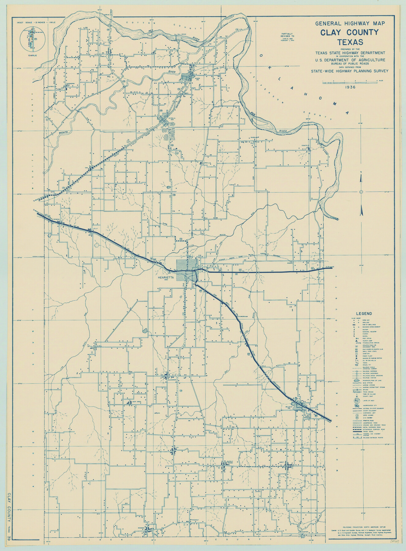
General Highway Map, Clay County, Texas
-
Map/Doc
79047
-
Collection
Texas State Library and Archives
-
Object Dates
1940 (Creation Date)
-
People and Organizations
Texas State Highway Department (Publisher)
-
Counties
Clay
-
Subjects
County
-
Height x Width
25.2 x 18.6 inches
64.0 x 47.2 cm
-
Comments
Prints available courtesy of the Texas State Library and Archives.
More info can be found here: TSLAC Map 04820
Part of: Texas State Library and Archives
General Highway Map, Zapata County, Texas

Print $20.00
General Highway Map, Zapata County, Texas
1940
Size 18.4 x 24.8 inches
Map/Doc 79287
General Highway Map, San Augustine County, Texas

Print $20.00
General Highway Map, San Augustine County, Texas
1940
Size 24.8 x 18.3 inches
Map/Doc 79235
Carte du Mexique ou de la Nouvelle Espagne

Print $20.00
Carte du Mexique ou de la Nouvelle Espagne
1750
Size 12.4 x 15.5 inches
Map/Doc 79741
General Highway Map, Washington County, Texas

Print $20.00
General Highway Map, Washington County, Texas
1961
Size 18.1 x 24.7 inches
Map/Doc 79703
General Highway Map, Sterling County, Texas

Print $20.00
General Highway Map, Sterling County, Texas
1940
Size 24.9 x 18.4 inches
Map/Doc 79248
General Highway Map, Throckmorton County, Texas

Print $20.00
General Highway Map, Throckmorton County, Texas
1961
Size 18.2 x 24.8 inches
Map/Doc 79676
General Highway Map. Detail of Cities and Towns in Harris County, Texas. City Map [of] Houston, Pasadena, West University Place, Bellaire, Galena Park, Jacinto City, South Houston, South Side Place, Deer Park, and vicinity, Harris County, Texas
![79506, General Highway Map. Detail of Cities and Towns in Harris County, Texas. City Map [of] Houston, Pasadena, West University Place, Bellaire, Galena Park, Jacinto City, South Houston, South Side Place, Deer Park, and vicinity, Harris County, Texas, Texas State Library and Archives](https://historictexasmaps.com/wmedia_w700/maps/79506.tif.jpg)
Print $20.00
General Highway Map. Detail of Cities and Towns in Harris County, Texas. City Map [of] Houston, Pasadena, West University Place, Bellaire, Galena Park, Jacinto City, South Houston, South Side Place, Deer Park, and vicinity, Harris County, Texas
1961
Size 18.0 x 24.9 inches
Map/Doc 79506
General Highway Map, Dickens County, Texas

Print $20.00
General Highway Map, Dickens County, Texas
1940
Size 18.3 x 25.3 inches
Map/Doc 79076
General Highway Map. Detail of Cities and Towns in Navarro County, Texas

Print $20.00
General Highway Map. Detail of Cities and Towns in Navarro County, Texas
1961
Size 19.3 x 25.0 inches
Map/Doc 79611
General Highway Map, Houston County, Texas

Print $20.00
General Highway Map, Houston County, Texas
1961
Size 24.7 x 18.2 inches
Map/Doc 79525
Greenville, Hunt County, Texas

Print $20.00
Greenville, Hunt County, Texas
1891
Size 21.9 x 36.5 inches
Map/Doc 79749
General Highway Map. Detail of Cities and Towns in Jefferson County, Texas. City Map of Port Arthur and vicinity, Jefferson County, Texas

Print $20.00
General Highway Map. Detail of Cities and Towns in Jefferson County, Texas. City Map of Port Arthur and vicinity, Jefferson County, Texas
1961
Size 18.0 x 24.7 inches
Map/Doc 79540
You may also like
Travis County Appraisal District Plat Map 2_2003

Print $20.00
- Digital $50.00
Travis County Appraisal District Plat Map 2_2003
Size 21.6 x 26.5 inches
Map/Doc 94202
Dallas County Sketch File 13

Print $12.00
- Digital $50.00
Dallas County Sketch File 13
1866
Size 12.8 x 8.2 inches
Map/Doc 20422
Montgomery County Sketch File 26

Print $6.00
- Digital $50.00
Montgomery County Sketch File 26
1845
Size 13.4 x 11.4 inches
Map/Doc 31871
King County Sketch File 8

Print $46.00
- Digital $50.00
King County Sketch File 8
Size 8.8 x 8.9 inches
Map/Doc 29060
Henderson County Rolled Sketch 11

Print $20.00
- Digital $50.00
Henderson County Rolled Sketch 11
1915
Size 29.5 x 42.5 inches
Map/Doc 75960
Hardin County Sketch File 27

Print $4.00
- Digital $50.00
Hardin County Sketch File 27
Size 13.0 x 8.1 inches
Map/Doc 25151
Liberty County Working Sketch 85

Print $20.00
- Digital $50.00
Liberty County Working Sketch 85
1987
Size 27.2 x 28.3 inches
Map/Doc 70545
Terrell County Rolled Sketch 34

Print $20.00
- Digital $50.00
Terrell County Rolled Sketch 34
1937
Size 29.3 x 25.3 inches
Map/Doc 7939
Right of Way and Track Map Houston & Texas Central R.R. operated by the T. & N.O. R.R. Co., Austin Branch

Print $40.00
- Digital $50.00
Right of Way and Track Map Houston & Texas Central R.R. operated by the T. & N.O. R.R. Co., Austin Branch
1918
Size 26.0 x 58.4 inches
Map/Doc 64556
Map of Anderson County, Texas

Print $20.00
- Digital $50.00
Map of Anderson County, Texas
1879
Size 18.5 x 21.7 inches
Map/Doc 377
Childress County Boundary File 3a

Print $80.00
- Digital $50.00
Childress County Boundary File 3a
Size 30.7 x 70.1 inches
Map/Doc 51354
Travis County Appraisal District Plat Map 2_0905

Print $20.00
- Digital $50.00
Travis County Appraisal District Plat Map 2_0905
Size 21.4 x 26.4 inches
Map/Doc 94232