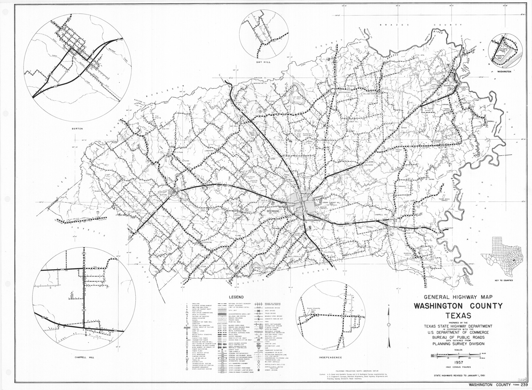
General Highway Map, Washington County, Texas
-
Map/Doc
79703
-
Collection
Texas State Library and Archives
-
Object Dates
1961 (Creation Date)
-
People and Organizations
Texas State Highway Department (Publisher)
-
Counties
Washington
-
Subjects
County
-
Height x Width
18.1 x 24.7 inches
46.0 x 62.7 cm
-
Comments
Prints available courtesy of the Texas State Library and Archives.
More info can be found here: TSLAC Map 05329
Part of: Texas State Library and Archives
United States Including California, Texas, and c.

Print $20.00
United States Including California, Texas, and c.
1861
Size 21.4 x 25.7 inches
Map/Doc 76238
General Highway Map, Goliad County, Texas

Print $20.00
General Highway Map, Goliad County, Texas
1961
Size 18.2 x 24.7 inches
Map/Doc 79481
General Highway Map, Lubbock County, Texas

Print $20.00
General Highway Map, Lubbock County, Texas
1961
Size 18.1 x 24.6 inches
Map/Doc 79578
General Highway Map, Kleberg County, Texas

Print $20.00
General Highway Map, Kleberg County, Texas
1961
Size 24.8 x 18.3 inches
Map/Doc 79558
General Highway Map, Victoria County, Texas

Print $20.00
General Highway Map, Victoria County, Texas
1961
Size 25.0 x 18.3 inches
Map/Doc 79697
General Highway Map, Trinity County, Texas

Print $20.00
General Highway Map, Trinity County, Texas
1940
Size 18.4 x 24.9 inches
Map/Doc 79263

General Highway Map, Comal County, Texas

Print $20.00
General Highway Map, Comal County, Texas
1961
Size 18.2 x 25.0 inches
Map/Doc 79417
General Highway Map, Upton County, Texas

Print $20.00
General Highway Map, Upton County, Texas
1940
Size 24.8 x 18.1 inches
Map/Doc 79265
Sectional Map of Texas Traversed by the Missouri, Kansas, and Texas Railway Showing the crops adapted to each section, with the elevation and annual rainfall.

Print $20.00
Sectional Map of Texas Traversed by the Missouri, Kansas, and Texas Railway Showing the crops adapted to each section, with the elevation and annual rainfall.
1909
Size 21.8 x 22.9 inches
Map/Doc 76265
General Highway Map, Sabine County, Texas

Print $20.00
General Highway Map, Sabine County, Texas
1940
Size 24.7 x 18.3 inches
Map/Doc 79233
General Highway Map, Aransas County, Texas

Print $20.00
General Highway Map, Aransas County, Texas
1940
Size 18.4 x 25.0 inches
Map/Doc 79004
You may also like
Harris County Rolled Sketch O

Print $20.00
- Digital $50.00
Harris County Rolled Sketch O
Size 19.3 x 28.9 inches
Map/Doc 6141
Bastrop County Sketch File 1a

Print $4.00
- Digital $50.00
Bastrop County Sketch File 1a
Size 8.4 x 12.8 inches
Map/Doc 14040
Kleberg County Rolled Sketch 10-23

Print $20.00
- Digital $50.00
Kleberg County Rolled Sketch 10-23
1953
Size 37.5 x 31.3 inches
Map/Doc 9396
Crockett County Sketch File 12

Print $20.00
- Digital $50.00
Crockett County Sketch File 12
Size 26.8 x 18.9 inches
Map/Doc 11216

[Sketch of part of G. & M. Block 5]
![93096, [Sketch of part of G. & M. Block 5], Twichell Survey Records](https://historictexasmaps.com/wmedia_w700/maps/93096-1.tif.jpg)
Print $2.00
- Digital $50.00
[Sketch of part of G. & M. Block 5]
Size 8.1 x 9.3 inches
Map/Doc 93096
The Pringle and Grieve Colony. November 1, 1843

Print $20.00
The Pringle and Grieve Colony. November 1, 1843
2020
Size 23.0 x 17.7 inches
Map/Doc 96371
Houston County Working Sketch 25

Print $40.00
- Digital $50.00
Houston County Working Sketch 25
1983
Size 43.6 x 89.0 inches
Map/Doc 66255
Hemphill County, State of Texas

Print $20.00
- Digital $50.00
Hemphill County, State of Texas
1888
Size 22.0 x 17.4 inches
Map/Doc 6187
[Blocks 36, 37 Township 2 South]
![92320, [Blocks 36, 37 Township 2 South], Twichell Survey Records](https://historictexasmaps.com/wmedia_w700/maps/92320-1.tif.jpg)
Print $20.00
- Digital $50.00
[Blocks 36, 37 Township 2 South]
Size 24.6 x 18.9 inches
Map/Doc 92320

