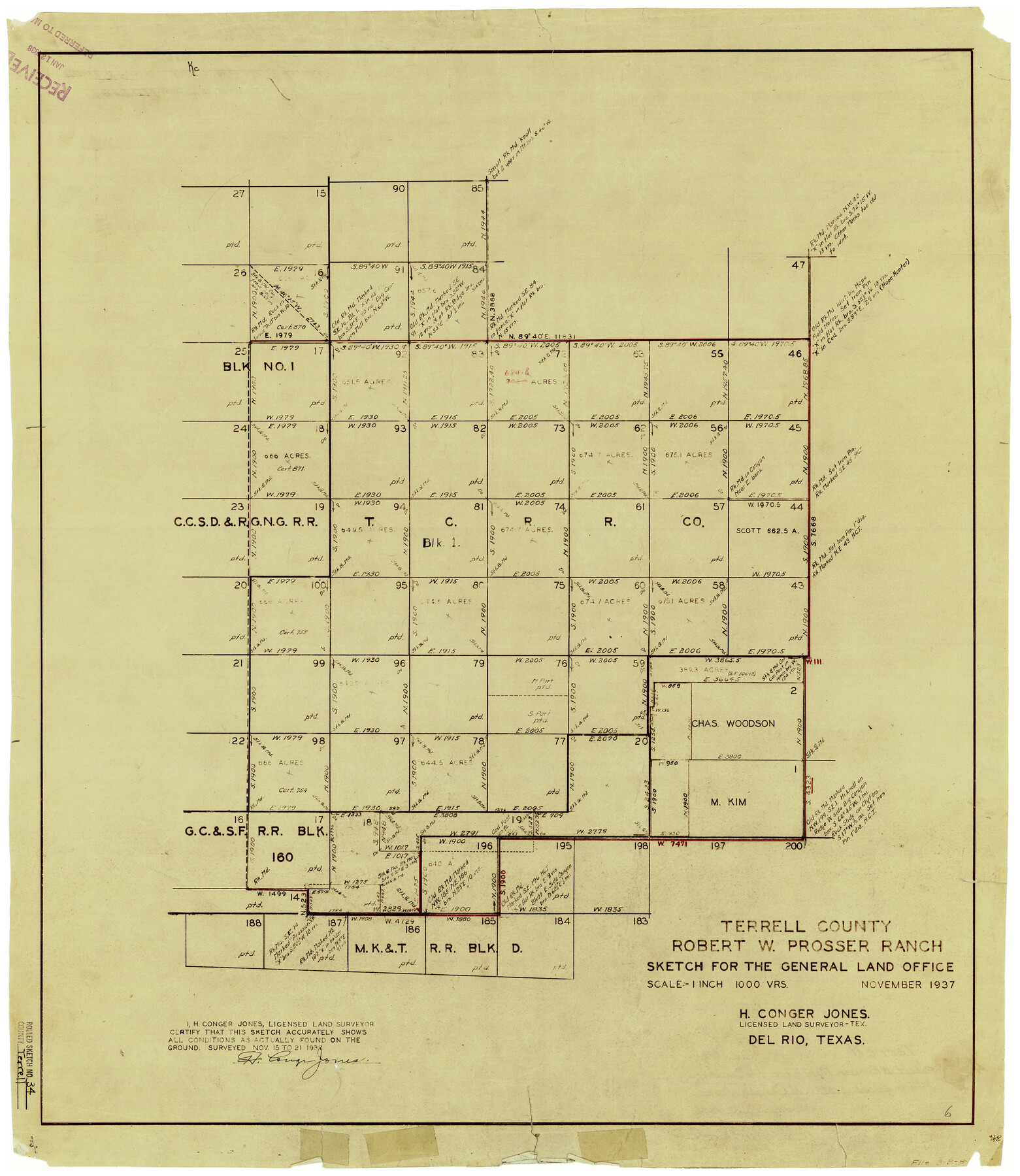
Terrell County Rolled Sketch 34
Terrell County, Robert W. Prosser Ranch
-
Map/Doc
7939
-
Collection
General Map Collection
-
Object Dates
11/21/1937 (Creation Date)
1/13/1938 (File Date)
-
People and Organizations
H. Conger Jones (Surveyor/Engineer)
-
Counties
Terrell
-
Subjects
Surveying Rolled Sketch
-
Height x Width
29.3 x 25.3 inches
74.4 x 64.3 cm
-
Medium
blueprint/diazo
-
Scale
1" = 1000 varas
Part of: General Map Collection
Val Verde County Sketch File 40A

Print $4.00
- Digital $50.00
Val Verde County Sketch File 40A
1939
Size 11.3 x 8.9 inches
Map/Doc 39307
Yoakum County

Print $20.00
- Digital $50.00
Yoakum County
1932
Size 47.1 x 35.6 inches
Map/Doc 63139
Chart of the West Indies and Spanish Dominions in North America

Print $20.00
- Digital $50.00
Chart of the West Indies and Spanish Dominions in North America
1803
Size 25.7 x 39.4 inches
Map/Doc 97137
United States - Gulf Coast Texas - Southern part of Laguna Madre

Print $20.00
- Digital $50.00
United States - Gulf Coast Texas - Southern part of Laguna Madre
1933
Size 26.8 x 18.3 inches
Map/Doc 72949
Flight Mission No. DQO-8K, Frame 143, Galveston County

Print $20.00
- Digital $50.00
Flight Mission No. DQO-8K, Frame 143, Galveston County
1952
Size 18.6 x 22.5 inches
Map/Doc 85205
Grayson County Working Sketch 11

Print $20.00
- Digital $50.00
Grayson County Working Sketch 11
1951
Size 27.9 x 24.3 inches
Map/Doc 63250
Foard County Working Sketch 13

Print $40.00
- Digital $50.00
Foard County Working Sketch 13
1981
Size 44.0 x 51.2 inches
Map/Doc 69204
Bowie County Working Sketch 11

Print $20.00
- Digital $50.00
Bowie County Working Sketch 11
1958
Size 43.2 x 31.6 inches
Map/Doc 67415

Henderson County Working Sketch 3

Print $20.00
- Digital $50.00
Henderson County Working Sketch 3
Size 28.5 x 38.3 inches
Map/Doc 66136
Comanche County Working Sketch 15

Print $20.00
- Digital $50.00
Comanche County Working Sketch 15
1964
Size 20.3 x 25.5 inches
Map/Doc 68149
Flight Mission No. DQN-1K, Frame 68, Calhoun County

Print $20.00
- Digital $50.00
Flight Mission No. DQN-1K, Frame 68, Calhoun County
1953
Size 18.6 x 22.2 inches
Map/Doc 84155
You may also like
Topographical Map of the Rio Grande, Sheet No. 20

Print $20.00
- Digital $50.00
Topographical Map of the Rio Grande, Sheet No. 20
1912
Map/Doc 89544
Cameron County Sketch File 16

Print $18.00
- Digital $50.00
Cameron County Sketch File 16
1998
Size 11.2 x 8.6 inches
Map/Doc 76334
Kent County Sketch File 6

Print $4.00
- Digital $50.00
Kent County Sketch File 6
1910
Size 8.3 x 7.0 inches
Map/Doc 28830
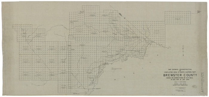
Brewster County Rolled Sketch 121
Print $40.00
- Digital $50.00
Brewster County Rolled Sketch 121
1942
Size 43.3 x 92.8 inches
Map/Doc 93790
The Land Grants of Texas

Print $20.00
The Land Grants of Texas
2014
Size 28.0 x 36.2 inches
Map/Doc 93698
Missouri Pacific Railway System

Print $20.00
- Digital $50.00
Missouri Pacific Railway System
1888
Size 20.0 x 20.0 inches
Map/Doc 89223
Hutchinson County Sketch File 41

Print $14.00
- Digital $50.00
Hutchinson County Sketch File 41
1955
Size 9.8 x 8.5 inches
Map/Doc 27298
Garza County Sketch File 20

Print $20.00
- Digital $50.00
Garza County Sketch File 20
1905
Size 8.7 x 7.8 inches
Map/Doc 24068
Nautical Chart 892-SC - Intracoastal Waterway - Carlos Bay to Redfish Bay including Copano Bay, Texas

Print $20.00
- Digital $50.00
Nautical Chart 892-SC - Intracoastal Waterway - Carlos Bay to Redfish Bay including Copano Bay, Texas
1972
Size 16.0 x 18.7 inches
Map/Doc 75912
Map of France, Spain, Portugal and Italy engraved to illustrate Mitchell's school and family geography (Inset: Greece and the Ionian Islands)

Print $20.00
- Digital $50.00
Map of France, Spain, Portugal and Italy engraved to illustrate Mitchell's school and family geography (Inset: Greece and the Ionian Islands)
1846
Size 9.5 x 11.8 inches
Map/Doc 93505
Gregg County Working Sketch 13

Print $20.00
- Digital $50.00
Gregg County Working Sketch 13
1940
Size 30.3 x 24.2 inches
Map/Doc 63280
Outer Continental Shelf Leasing Maps (Louisiana Offshore Operations)

Print $20.00
- Digital $50.00
Outer Continental Shelf Leasing Maps (Louisiana Offshore Operations)
1954
Size 12.6 x 14.4 inches
Map/Doc 76113