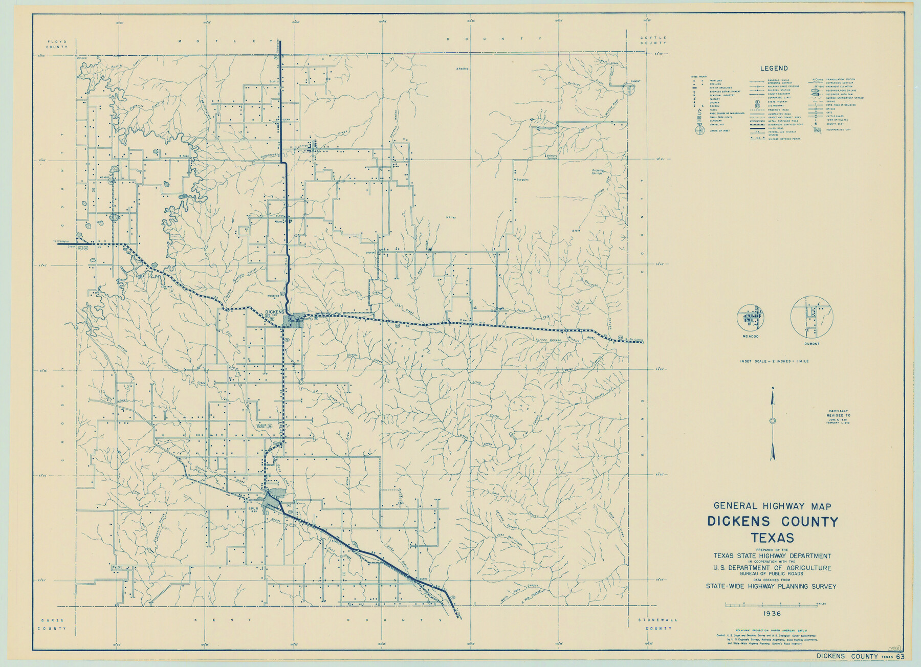
General Highway Map, Dickens County, Texas
- 
                          Map/Doc
79076
 - 
                            Collection
Texas State Library and Archives
 - 
                            Object Dates
1940 (Creation Date)
 - 
                            People and Organizations
Texas State Highway Department (Publisher)
 - 
                            Counties
Dickens
 - 
                            Subjects
County
 - 
                            Height x Width
18.3 x 25.3 inches
46.5 x 64.3 cm
 - 
                            Comments
Prints available courtesy of the Texas State Library and Archives.
More info can be found here: TSLAC Map 04845 
Part of: Texas State Library and Archives
            General Highway Map, Houston County, Texas


                                            Print $20.00                    
                                    
                General Highway Map, Houston County, Texas
1940
Size 18.3 x 24.8 inches
                                Map/Doc 79133
            
            General Highway Map, Garza County, Texas


                                            Print $20.00                    
                                    
                General Highway Map, Garza County, Texas
1961
Size 18.2 x 24.6 inches
                                Map/Doc 79478
            
            General Highway Map, Cooke County, Texas


                                            Print $20.00                    
                                    
                General Highway Map, Cooke County, Texas
1940
Size 25.2 x 18.3 inches
                                Map/Doc 79058
            
            General Highway Map, Randall County, Texas


                                            Print $20.00                    
                                    
                General Highway Map, Randall County, Texas
1961
Size 18.1 x 24.5 inches
                                Map/Doc 79635
            
            General Highway Map, Gray County, Texas


                                            Print $20.00                    
                                    
                General Highway Map, Gray County, Texas
1940
Size 25.0 x 18.4 inches
                                Map/Doc 79103
            
            General Highway Map, Harrison County, Texas


                                            Print $20.00                    
                                    
                General Highway Map, Harrison County, Texas
1940
Size 18.2 x 24.8 inches
                                Map/Doc 79121
            
            General Highway Map, Matagorda County, Texas


                                            Print $20.00                    
                                    
                General Highway Map, Matagorda County, Texas
1961
Size 24.7 x 18.2 inches
                                Map/Doc 79586
            
            Map of Texas Containing the Latest Grants and Discoveries


                                            Print $20.00                    
                                    
                Map of Texas Containing the Latest Grants and Discoveries
1836
Size 16.2 x 10.6 inches
                                Map/Doc 76245
            
            General Highway Map, Galveston County, Texas


                                            Print $20.00                    
                                    
                General Highway Map, Galveston County, Texas
1939
Size 18.5 x 25.0 inches
                                Map/Doc 79096
            
            General Highway Map, Hidalgo County, Texas


                                            Print $20.00                    
                                    
                General Highway Map, Hidalgo County, Texas
1940
Size 18.4 x 24.7 inches
                                Map/Doc 79127
            
            The Texas New Yorker's Map of the U. S. Accompanying the Map of Texas


                                            Print $20.00                    
                                    
                The Texas New Yorker's Map of the U. S. Accompanying the Map of Texas
1874
Size 32.3 x 22.8 inches
                                Map/Doc 76211
            
            General Highway Map, Taylor County, Texas


                                            Print $20.00                    
                                    
                General Highway Map, Taylor County, Texas
1961
Size 18.2 x 24.8 inches
                                Map/Doc 79672
            You may also like
            Howard County Boundary File 3a


                                            Print $62.00                    
                                             -                         Digital $50.00                                    
                Howard County Boundary File 3a
Size 3.9 x 8.7 inches
                                Map/Doc 55155
            
            Fractional Township No. 9 South Range No. 24 East of the Indian Meridian, Indian Territory


                                            Print $20.00                    
                                             -                         Digital $50.00                                    
                Fractional Township No. 9 South Range No. 24 East of the Indian Meridian, Indian Territory
1898
Size 19.2 x 24.3 inches
                                Map/Doc 75241
            
            Flight Mission No. BRE-1P, Frame 117, Nueces County


                                            Print $20.00                    
                                             -                         Digital $50.00                                    
                Flight Mission No. BRE-1P, Frame 117, Nueces County
1956
Size 18.4 x 22.3 inches
                                Map/Doc 86683
            
            [1680 Bed of Rock 20 Feet in Diameter on East Bank of Concho Drain]


                                            Print $20.00                    
                                             -                         Digital $50.00                                    
                [1680 Bed of Rock 20 Feet in Diameter on East Bank of Concho Drain]
Size 25.4 x 15.1 inches
                                Map/Doc 91361
            
            Eastland County Working Sketch 57


                                            Print $20.00                    
                                             -                         Digital $50.00                                    
                Eastland County Working Sketch 57
1985
Size 21.7 x 21.8 inches
                                Map/Doc 68838
            
            Liberty County Working Sketch 35


                                            Print $20.00                    
                                             -                         Digital $50.00                                    
                Liberty County Working Sketch 35
1948
Size 22.3 x 42.3 inches
                                Map/Doc 70494
            
            Comal County Sketch File 20


                                            Print $6.00                    
                                             -                         Digital $50.00                                    
                Comal County Sketch File 20
1857
Size 12.4 x 8.1 inches
                                Map/Doc 19039
            
            Falls County Working Sketch 5


                                            Print $40.00                    
                                             -                         Digital $50.00                                    
                Falls County Working Sketch 5
2008
Size 34.3 x 56.6 inches
                                Map/Doc 88885
            
            Webb County Rolled Sketch 68


                                            Print $43.00                    
                                             -                         Digital $50.00                                    
                Webb County Rolled Sketch 68
1910
Size 9.6 x 15.1 inches
                                Map/Doc 49485
            
            Knox County Rolled Sketch 24


                                            Print $20.00                    
                                             -                         Digital $50.00                                    
                Knox County Rolled Sketch 24
2007
Size 28.5 x 34.5 inches
                                Map/Doc 87722
            
            [Right of Way Map, Belton Branch of the M.K.&T. RR.]


                                            Print $20.00                    
                                             -                         Digital $50.00                                    
                [Right of Way Map, Belton Branch of the M.K.&T. RR.]
1896
Size 22.0 x 7.1 inches
                                Map/Doc 64221