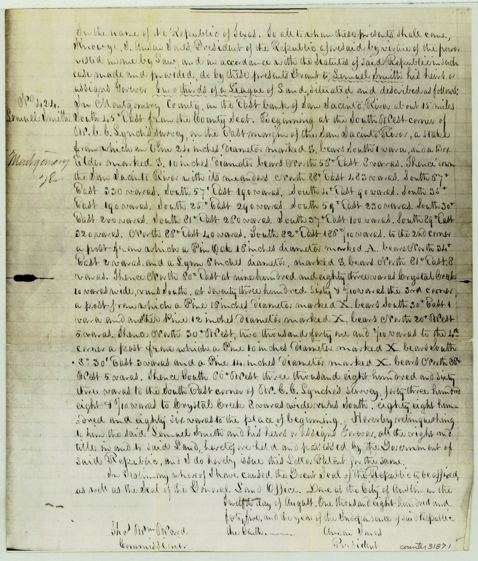
Montgomery County Sketch File 26
[Copy of the patent of the Lemuel Smith 2/3 League]
-
Map/Doc
31871
-
Collection
General Map Collection
-
Object Dates
8/12/1845 (Creation Date)
-
People and Organizations
Anson Jones (President)
Thomas William Ward (GLO Commissioner)
-
Counties
Montgomery
-
Subjects
Surveying Sketch File
-
Height x Width
13.4 x 11.4 inches
34.0 x 29.0 cm
-
Medium
photostat
-
Features
San Jacinto River
Crystal Creek
Part of: General Map Collection
Live Oak County Sketch File 27

Print $4.00
- Digital $50.00
Live Oak County Sketch File 27
1922
Size 14.3 x 8.7 inches
Map/Doc 30312
Jefferson County Rolled Sketch 61F

Print $20.00
- Digital $50.00
Jefferson County Rolled Sketch 61F
1928
Size 27.2 x 40.2 inches
Map/Doc 6415
Flight Mission No. CRK-5P, Frame 162, Refugio County

Print $20.00
- Digital $50.00
Flight Mission No. CRK-5P, Frame 162, Refugio County
1956
Size 18.5 x 22.3 inches
Map/Doc 86943
Padre Island National Seashore

Print $4.00
- Digital $50.00
Padre Island National Seashore
Size 16.0 x 21.9 inches
Map/Doc 60526
Wise County Sketch File 32

Print $5.00
- Digital $50.00
Wise County Sketch File 32
1880
Size 16.4 x 11.0 inches
Map/Doc 40588
Upton County Rolled Sketch 59A

Print $20.00
- Digital $50.00
Upton County Rolled Sketch 59A
Size 35.7 x 45.9 inches
Map/Doc 76423
Wichita County Sketch File I

Print $4.00
- Digital $50.00
Wichita County Sketch File I
1885
Size 10.3 x 8.2 inches
Map/Doc 40091
Harris County Sketch File 86

Print $20.00
- Digital $50.00
Harris County Sketch File 86
1894
Size 34.7 x 21.3 inches
Map/Doc 11674
Liberty County Working Sketch 67

Print $20.00
- Digital $50.00
Liberty County Working Sketch 67
1971
Size 35.3 x 44.5 inches
Map/Doc 70527
Map of Karnes County

Print $20.00
- Digital $50.00
Map of Karnes County
1856
Size 26.2 x 22.4 inches
Map/Doc 3745
Garza County Rolled Sketch 6D

Print $20.00
- Digital $50.00
Garza County Rolled Sketch 6D
1913
Size 17.4 x 16.0 inches
Map/Doc 5998
Lampasas County Boundary File 2

Print $4.00
- Digital $50.00
Lampasas County Boundary File 2
Size 13.8 x 8.8 inches
Map/Doc 56095
You may also like
Map of Glasscock County

Print $20.00
- Digital $50.00
Map of Glasscock County
Size 18.9 x 23.2 inches
Map/Doc 90711
Treaty to Resolve Pending Boundary Differences and Maintain the Rio Grande and Colorado River as the International Boundary Between the United States of American and Mexico

Print $20.00
- Digital $50.00
Treaty to Resolve Pending Boundary Differences and Maintain the Rio Grande and Colorado River as the International Boundary Between the United States of American and Mexico
1970
Size 11.0 x 35.2 inches
Map/Doc 83105
Crosby County Sketch File 21

Print $6.00
- Digital $50.00
Crosby County Sketch File 21
Size 13.8 x 8.8 inches
Map/Doc 20087
Map of the chief part of the Western States and part of Virginia engraved to illustrate Mitchell's school and family geography

Print $20.00
- Digital $50.00
Map of the chief part of the Western States and part of Virginia engraved to illustrate Mitchell's school and family geography
1839
Size 11.8 x 17.8 inches
Map/Doc 93499
Section 1, Block AX, Gaines County, Texas

Print $3.00
- Digital $50.00
Section 1, Block AX, Gaines County, Texas
1952
Size 11.1 x 13.1 inches
Map/Doc 92670
General Highway Map, El Paso County, Texas

Print $20.00
General Highway Map, El Paso County, Texas
1961
Size 18.2 x 24.8 inches
Map/Doc 79458
[Tex Mex & CCSDRG&G Railroad Blocks in Starr and Hidalgo Counties, Texas]
![4452, [Tex Mex & CCSDRG&G Railroad Blocks in Starr and Hidalgo Counties, Texas], Maddox Collection](https://historictexasmaps.com/wmedia_w700/maps/4452-1.tif.jpg)
Print $20.00
- Digital $50.00
[Tex Mex & CCSDRG&G Railroad Blocks in Starr and Hidalgo Counties, Texas]
1906
Size 28.7 x 24.2 inches
Map/Doc 4452
Aransas County Rolled Sketch 4

Print $20.00
- Digital $50.00
Aransas County Rolled Sketch 4
1952
Size 28.9 x 26.4 inches
Map/Doc 77189
Working Sketch in Archer County

Print $20.00
- Digital $50.00
Working Sketch in Archer County
1924
Size 30.3 x 42.2 inches
Map/Doc 90171
Somervell County Working Sketch 5

Print $20.00
- Digital $50.00
Somervell County Working Sketch 5
1975
Size 33.3 x 39.4 inches
Map/Doc 63909
Kendall County Working Sketch 23

Print $20.00
- Digital $50.00
Kendall County Working Sketch 23
1974
Size 21.7 x 24.5 inches
Map/Doc 66695
Bell County Sketch File 26a

Print $4.00
- Digital $50.00
Bell County Sketch File 26a
1883
Size 9.0 x 9.6 inches
Map/Doc 14433