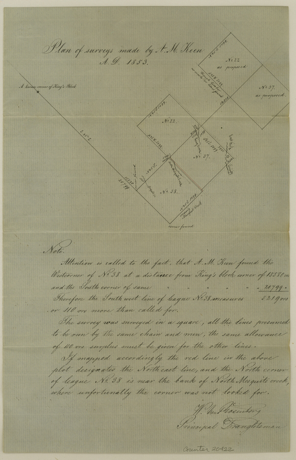
Dallas County Sketch File 13
[Sketches and statement in regard to A. M. Keen's survey compared with field notes]
-
Map/Doc
20422
-
Collection
General Map Collection
-
Object Dates
1866/10/12 (Creation Date)
-
People and Organizations
W. von Rosenberg (Draftsman)
A.M. Keen (Surveyor/Engineer)
-
Counties
Dallas
-
Subjects
Surveying Sketch File
-
Height x Width
12.8 x 8.2 inches
32.5 x 20.8 cm
-
Medium
paper, manuscript
-
Features
East Prong of Trinity River
North Mesquite Creek
Long Creek
Mesquite Creek
East Fork of Trinity River
Trinity River
Part of: General Map Collection
Montgomery County Working Sketch 53

Print $20.00
- Digital $50.00
Montgomery County Working Sketch 53
1961
Size 28.2 x 30.2 inches
Map/Doc 71160
Sabine County Sketch File 4

Print $22.00
Sabine County Sketch File 4
1876
Size 8.1 x 12.8 inches
Map/Doc 35606
Flight Mission No. CGI-3N, Frame 181, Cameron County

Print $20.00
- Digital $50.00
Flight Mission No. CGI-3N, Frame 181, Cameron County
1954
Size 18.5 x 22.2 inches
Map/Doc 84645
Anderson County Sketch File 29

Print $4.00
- Digital $50.00
Anderson County Sketch File 29
1873
Size 10.4 x 8.2 inches
Map/Doc 12814
Map of Part of Texas Prison System, Blue Ridge State Farm near Camp No. 1 Showing Buildings and Property Lines

Print $20.00
- Digital $50.00
Map of Part of Texas Prison System, Blue Ridge State Farm near Camp No. 1 Showing Buildings and Property Lines
Size 20.3 x 25.4 inches
Map/Doc 62980
Map of Houston & Overton Branch Railroad

Print $40.00
- Digital $50.00
Map of Houston & Overton Branch Railroad
1877
Size 22.3 x 110.1 inches
Map/Doc 64460
Mills County Rolled Sketch 7

Print $20.00
- Digital $50.00
Mills County Rolled Sketch 7
2025
Size 23.7 x 29.8 inches
Map/Doc 97434
Railroad Track Map, T&PRRCo., Culberson County, Texas

Print $4.00
- Digital $50.00
Railroad Track Map, T&PRRCo., Culberson County, Texas
1910
Size 11.7 x 18.6 inches
Map/Doc 62829
San Saba County

Print $20.00
- Digital $50.00
San Saba County
1918
Size 46.8 x 41.2 inches
Map/Doc 63022
Palo Pinto County Sketch File 21

Print $20.00
- Digital $50.00
Palo Pinto County Sketch File 21
1896
Size 18.5 x 17.5 inches
Map/Doc 12133
[Map of Jackson County]
![78359, [Map of Jackson County], General Map Collection](https://historictexasmaps.com/wmedia_w700/maps/78359.tif.jpg)
Print $20.00
- Digital $50.00
[Map of Jackson County]
1836
Size 32.8 x 21.1 inches
Map/Doc 78359
Travis County Sketch File 46

Print $20.00
- Digital $50.00
Travis County Sketch File 46
1939
Size 21.0 x 21.2 inches
Map/Doc 12468
You may also like
Newton County Working Sketch 24

Print $20.00
- Digital $50.00
Newton County Working Sketch 24
1953
Size 13.4 x 16.1 inches
Map/Doc 71270
Wise County Working Sketch 31

Print $20.00
- Digital $50.00
Wise County Working Sketch 31
2009
Size 27.9 x 37.5 inches
Map/Doc 89985
Tyler County Sketch File 1

Print $22.00
- Digital $50.00
Tyler County Sketch File 1
1849
Size 12.2 x 15.3 inches
Map/Doc 38607
Liberty County Working Sketch 20

Print $20.00
- Digital $50.00
Liberty County Working Sketch 20
1940
Size 14.5 x 17.7 inches
Map/Doc 70479
Maverick County Sketch File 17

Print $20.00
- Digital $50.00
Maverick County Sketch File 17
Size 15.4 x 18.2 inches
Map/Doc 12052
Fisher County Rolled Sketch 4A

Print $20.00
- Digital $50.00
Fisher County Rolled Sketch 4A
1951
Size 31.0 x 36.6 inches
Map/Doc 8889
[Charles Welch, J. D. Brown, and surrounding surveys]
![91010, [Charles Welch, J. D. Brown, and surrounding surveys], Twichell Survey Records](https://historictexasmaps.com/wmedia_w700/maps/91010-1.tif.jpg)
Print $20.00
- Digital $50.00
[Charles Welch, J. D. Brown, and surrounding surveys]
Size 37.4 x 24.0 inches
Map/Doc 91010

[Blocks L. E. and B8]
![90666, [Blocks L. E. and B8], Twichell Survey Records](https://historictexasmaps.com/wmedia_w700/maps/90666-2.tif.jpg)
Print $20.00
- Digital $50.00
[Blocks L. E. and B8]
Size 18.4 x 13.6 inches
Map/Doc 90666

Flight Mission No. DQN-1K, Frame 153, Calhoun County

Print $20.00
- Digital $50.00
Flight Mission No. DQN-1K, Frame 153, Calhoun County
1953
Size 18.6 x 22.3 inches
Map/Doc 84212
Archer County Boundary File 6

Print $62.00
- Digital $50.00
Archer County Boundary File 6
Size 22.5 x 6.1 inches
Map/Doc 50113