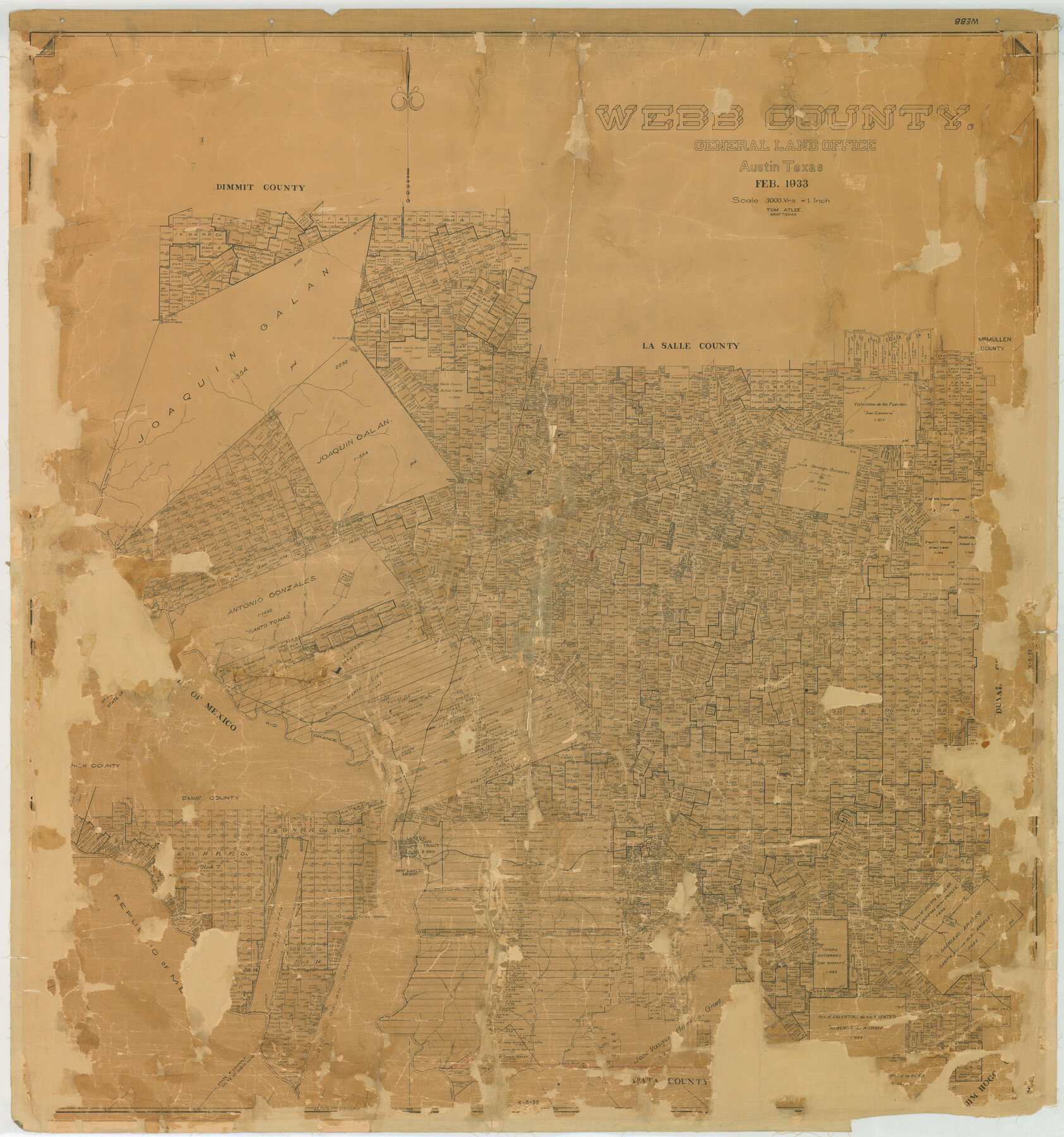
Webb County
K-5-35
-
Map/Doc
78443
-
Collection
General Map Collection
-
Object Dates
1933 (Creation Date)
-
People and Organizations
Texas General Land Office (Publisher)
Tom G. Atlee (Compiler)
Tom G. Atlee (Draftsman)
-
Counties
Webb
-
Subjects
County
-
Height x Width
55.0 x 51.5 inches
139.7 x 130.8 cm
-
Comments
Note on back: Replaced by copy Sept. 8, 1947".
Help Save Texas History - Adopt Me! -
Features
San Casimiro Creek
Los Cristales Creek
El Venado Creek
Abra Bonita Creek
La Espada Creek
Serrito Prieto
San Pedro Hill
La Moca Creek
Serrita Chequita Creek
Callaghan
Cactus
Rancherias Creek
La Volanta Creek
Salado Creek
El Suisache Creek
Tanquecillos Creek
Webb
Tordillo Creek
Tejones Creek
Santa Isabel Creek
Zacatosa Creek
Santo Tomas
Cannel Darwin Post Office
Dolores
Ortagilla Creek
Branch of Charco Escondido
El Gato Creek
Arroyo Abra de Vela
Orvil
Sanchez Hill Spur
Rio Grande
Sada
El Chacon Creek
Arroyo de San Ignacio
Carrecitos Creek
Sanchez
Davis
Nye
Love
Chapadera Creek
Ambrosia Creek
San Pedro Creek
Laredo
Zocata Creek
Torrecillas
Oilton
San Juanito Creek
Loma Alta Mountain
Bruni
Arroyo de Los Angelos
El Lobo Creek
Derrymadero del Carba Creek
Arroyo Serrito Prieto
Agua Azul Creek
Las Meritas Creek
Lakoya Creek
El Sauz Creek
Becerra Creek
Rio Grande City Railroad
El Espejo Creek
San Cerildo Creek
La Posada Creek
Pilotes Creek
Canada de San Andres Creek
El Saez Creek
Las Blancas Creek
Laguna de Hilario
Laguna Zacatan
El Amuc
El Piloncillo
Las Raices Creek
Los Dos Hermanos
Nueces River
Charamusco Creek
Prieto Creek
Palito Blanco Creek
Encinal
Jaboncillos Creek
Vidales
Los Olmos Creek
Magueyitos Creek
Magueyitos Hill
Cochipa Creek
La Parida Creek
Baranquitas Creek
Las Pintas Creek
Rodriguez
Tinaja Escondido Creek
Buena Vista Creek
Ramberias Creek
Alamito Creek
Carrizitos Creek
Llave Creek
Saucillo Creek
Santo Tomas Creek
Charco
Ventura Creek
Navajo Creek
[ ] Pato Creek
Arroyo del Relacion
El Salado Creek
San Isabel
Leyendecker
Telitas
Simon
Joyce Post Office
Jacalon Hill
Petscadito
Reiser
Arroyo del Guarmito
Lorenz Creek
Arroyo Jobero
Laguna del Javali
Arroyo Becerrit
La Bibora [Creek]
Dolores Creek
Part of: General Map Collection
Kleberg County Boundary File 1

Print $10.00
- Digital $50.00
Kleberg County Boundary File 1
Size 9.3 x 5.9 inches
Map/Doc 64961
Terrell County Working Sketch 7

Print $20.00
- Digital $50.00
Terrell County Working Sketch 7
1915
Size 42.2 x 31.3 inches
Map/Doc 62156
Limestone County Sketch File 2

Print $2.00
- Digital $50.00
Limestone County Sketch File 2
Size 8.0 x 6.2 inches
Map/Doc 30157
McMullen County Sketch File 10

Print $40.00
- Digital $50.00
McMullen County Sketch File 10
1876
Size 14.3 x 17.6 inches
Map/Doc 31353
Live Oak County Sketch File 7

Print $4.00
- Digital $50.00
Live Oak County Sketch File 7
1875
Size 8.8 x 8.3 inches
Map/Doc 30259
[Copied from a chart of Galveston Bar and Harbor]
![72760, [Copied from a chart of Galveston Bar and Harbor], General Map Collection](https://historictexasmaps.com/wmedia_w700/maps/72760.tif.jpg)
Print $20.00
- Digital $50.00
[Copied from a chart of Galveston Bar and Harbor]
1846
Size 18.3 x 25.3 inches
Map/Doc 72760
San Saba County Working Sketch 3

Print $20.00
- Digital $50.00
San Saba County Working Sketch 3
1941
Size 27.3 x 20.7 inches
Map/Doc 63791
Map of the State of Texas

Print $40.00
- Digital $50.00
Map of the State of Texas
1879
Size 102.3 x 56.2 inches
Map/Doc 93384
Tyler County Rolled Sketch 9

Print $20.00
- Digital $50.00
Tyler County Rolled Sketch 9
Size 43.3 x 25.6 inches
Map/Doc 8059
Trinity River, Trinidad Sheet

Print $20.00
- Digital $50.00
Trinity River, Trinidad Sheet
1928
Size 39.0 x 46.3 inches
Map/Doc 65183
Map of The Surveyed Part of Peters Colony Texas

Print $40.00
- Digital $50.00
Map of The Surveyed Part of Peters Colony Texas
1852
Size 53.0 x 28.1 inches
Map/Doc 1964
Nueces County Rolled Sketch 128

Print $20.00
- Digital $50.00
Nueces County Rolled Sketch 128
1998
Size 18.3 x 24.5 inches
Map/Doc 7163
You may also like
Matagorda County Boundary File 1a

Print $8.00
- Digital $50.00
Matagorda County Boundary File 1a
Size 14.2 x 8.6 inches
Map/Doc 56889
Runnels County Working Sketch 25

Print $20.00
- Digital $50.00
Runnels County Working Sketch 25
1955
Size 38.2 x 47.1 inches
Map/Doc 63621
Coke County Rolled Sketch 15A

Print $20.00
- Digital $50.00
Coke County Rolled Sketch 15A
1949
Size 43.8 x 44.3 inches
Map/Doc 8629
Floyd County Sketch File 6

Print $2.00
- Digital $50.00
Floyd County Sketch File 6
Size 9.1 x 14.4 inches
Map/Doc 22696
Colorado County Working Sketch 3

Print $20.00
- Digital $50.00
Colorado County Working Sketch 3
1911
Size 23.2 x 19.2 inches
Map/Doc 68103
Plano de la Sauteña. Indicando los terrenos irrigados en Texas

Plano de la Sauteña. Indicando los terrenos irrigados en Texas
Size 38.6 x 37.8 inches
Map/Doc 94566
Part of a map showing resurvey of Capitol Leagues by R. S. Hunnicutt & Behn Cook State Surveyors

Print $20.00
- Digital $50.00
Part of a map showing resurvey of Capitol Leagues by R. S. Hunnicutt & Behn Cook State Surveyors
Size 21.6 x 17.3 inches
Map/Doc 90277
Gulf Intracoastal Waterway - Aransas Bay to Corpus Christi Bay - Modified Route Main Channel

Print $20.00
- Digital $50.00
Gulf Intracoastal Waterway - Aransas Bay to Corpus Christi Bay - Modified Route Main Channel
Size 30.9 x 41.9 inches
Map/Doc 61904

Bowie County Rolled Sketch 2

Print $40.00
- Digital $50.00
Bowie County Rolled Sketch 2
Size 37.8 x 51.3 inches
Map/Doc 8454
Refugio County Working Sketch 13

Print $20.00
- Digital $50.00
Refugio County Working Sketch 13
1961
Size 23.8 x 29.8 inches
Map/Doc 63522
Cass County Working Sketch 2

Print $20.00
- Digital $50.00
Cass County Working Sketch 2
1935
Size 24.7 x 36.7 inches
Map/Doc 67905