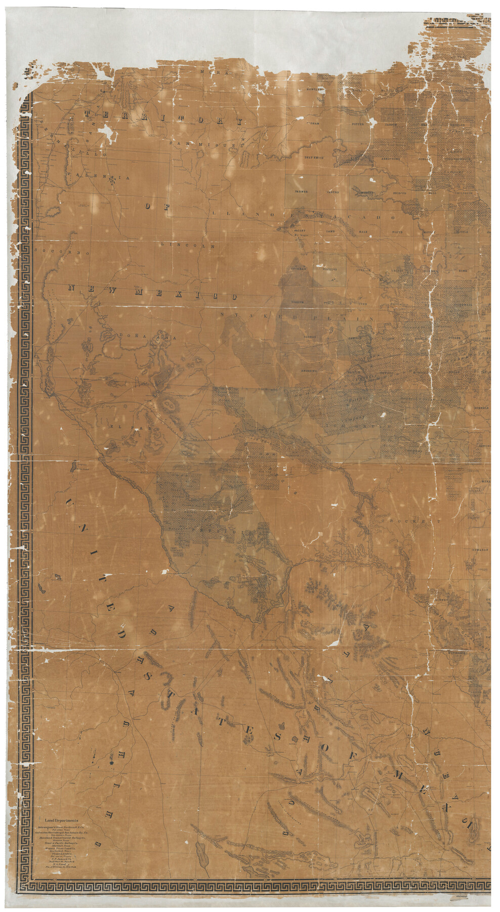
Map of the State of Texas
Compiled from the records on file in the General Land Office of the State, the U.S. coast surveys, the reports of the Mexican & U.S. boundary commissions & topographical maps of army officers
-
Map/Doc
93384
-
Collection
General Map Collection
-
Object Dates
1879 (Creation Date)
-
People and Organizations
Texas General Land Office (Publisher)
Am. Photo-Lithographical Co. (Printer)
Chas. W. Pressler (Draftsman)
W.C. Walsh (GLO Commissioner)
A.B. Langermann (Compiler)
-
Subjects
State of Texas
-
Height x Width
102.3 x 56.2 inches
259.8 x 142.8 cm
-
Comments
West part of map. For east part see 93385. For digital composite of both halves see 16974.
Conservation funded in 2001.
Related maps
Map of the State of Texas

Print $40.00
- Digital $50.00
Map of the State of Texas
1879
Size 102.3 x 106.1 inches
Map/Doc 16974
Map of the State of Texas

Print $40.00
- Digital $50.00
Map of the State of Texas
1879
Size 102.3 x 57.5 inches
Map/Doc 93385
Part of: General Map Collection
Hartley County Working Sketch 6

Print $20.00
- Digital $50.00
Hartley County Working Sketch 6
1971
Size 37.0 x 37.0 inches
Map/Doc 66056
Pecos County Working Sketch 73

Print $40.00
- Digital $50.00
Pecos County Working Sketch 73
1957
Size 110.6 x 38.7 inches
Map/Doc 71545
Duval County Sketch File 1

Print $40.00
- Digital $50.00
Duval County Sketch File 1
1848
Size 12.7 x 16.2 inches
Map/Doc 21278
Comanche County Sketch File 2

Print $40.00
- Digital $50.00
Comanche County Sketch File 2
1849
Size 16.0 x 12.9 inches
Map/Doc 19053
Edwards County Sketch File 34

Print $20.00
- Digital $50.00
Edwards County Sketch File 34
Size 16.8 x 19.0 inches
Map/Doc 11434
Flight Mission No. CRC-2R, Frame 59, Chambers County

Print $20.00
- Digital $50.00
Flight Mission No. CRC-2R, Frame 59, Chambers County
1956
Size 18.7 x 22.5 inches
Map/Doc 84730

San Patricio County Working Sketch 14

Print $20.00
- Digital $50.00
San Patricio County Working Sketch 14
1949
Size 34.9 x 28.2 inches
Map/Doc 63776
Terrell County Working Sketch 5

Print $20.00
- Digital $50.00
Terrell County Working Sketch 5
1914
Size 32.0 x 26.3 inches
Map/Doc 62154
Maps of Gulf Intracoastal Waterway, Texas - Sabine River to the Rio Grande and connecting waterways including ship channels

Print $20.00
- Digital $50.00
Maps of Gulf Intracoastal Waterway, Texas - Sabine River to the Rio Grande and connecting waterways including ship channels
1966
Size 15.7 x 22.0 inches
Map/Doc 61983

You may also like
Tyler County Sketch File 6

Print $6.00
- Digital $50.00
Tyler County Sketch File 6
1848
Size 6.0 x 7.1 inches
Map/Doc 38630
Harrison County Working Sketch 14

Print $20.00
- Digital $50.00
Harrison County Working Sketch 14
1961
Size 35.6 x 32.0 inches
Map/Doc 66034
Map of Galveston, Turtle & East Bays & portions of the Gulf of Mexico in Chambers & Galveston Counties, Texas showing subdivision for mineral development

Print $40.00
- Digital $50.00
Map of Galveston, Turtle & East Bays & portions of the Gulf of Mexico in Chambers & Galveston Counties, Texas showing subdivision for mineral development
Size 50.0 x 55.2 inches
Map/Doc 65807

Flight Mission No. CUG-1P, Frame 19, Kleberg County

Print $20.00
- Digital $50.00
Flight Mission No. CUG-1P, Frame 19, Kleberg County
1956
Size 18.6 x 22.2 inches
Map/Doc 86109
Brewster County Sketch File NS-3

Print $40.00
- Digital $50.00
Brewster County Sketch File NS-3
1913
Size 30.9 x 15.6 inches
Map/Doc 10986
Flight Mission No. DQO-7K, Frame 78, Galveston County

Print $20.00
- Digital $50.00
Flight Mission No. DQO-7K, Frame 78, Galveston County
1952
Size 18.8 x 22.4 inches
Map/Doc 85105
Galveston County Rolled Sketch 31

Print $20.00
- Digital $50.00
Galveston County Rolled Sketch 31
1979
Size 28.4 x 39.8 inches
Map/Doc 5965
Presidio County Rolled Sketch 34

Print $20.00
- Digital $50.00
Presidio County Rolled Sketch 34
1890
Size 46.1 x 32.9 inches
Map/Doc 9773
Culberson County Sketch File EM and RJ

Print $24.00
- Digital $50.00
Culberson County Sketch File EM and RJ
Size 13.3 x 8.8 inches
Map/Doc 20157
Runnels County Sketch File 15

Print $42.00
Runnels County Sketch File 15
1883
Size 9.2 x 7.9 inches
Map/Doc 35459
Van Zandt County Sketch File 25

Print $4.00
- Digital $50.00
Van Zandt County Sketch File 25
Size 7.6 x 8.8 inches
Map/Doc 39443