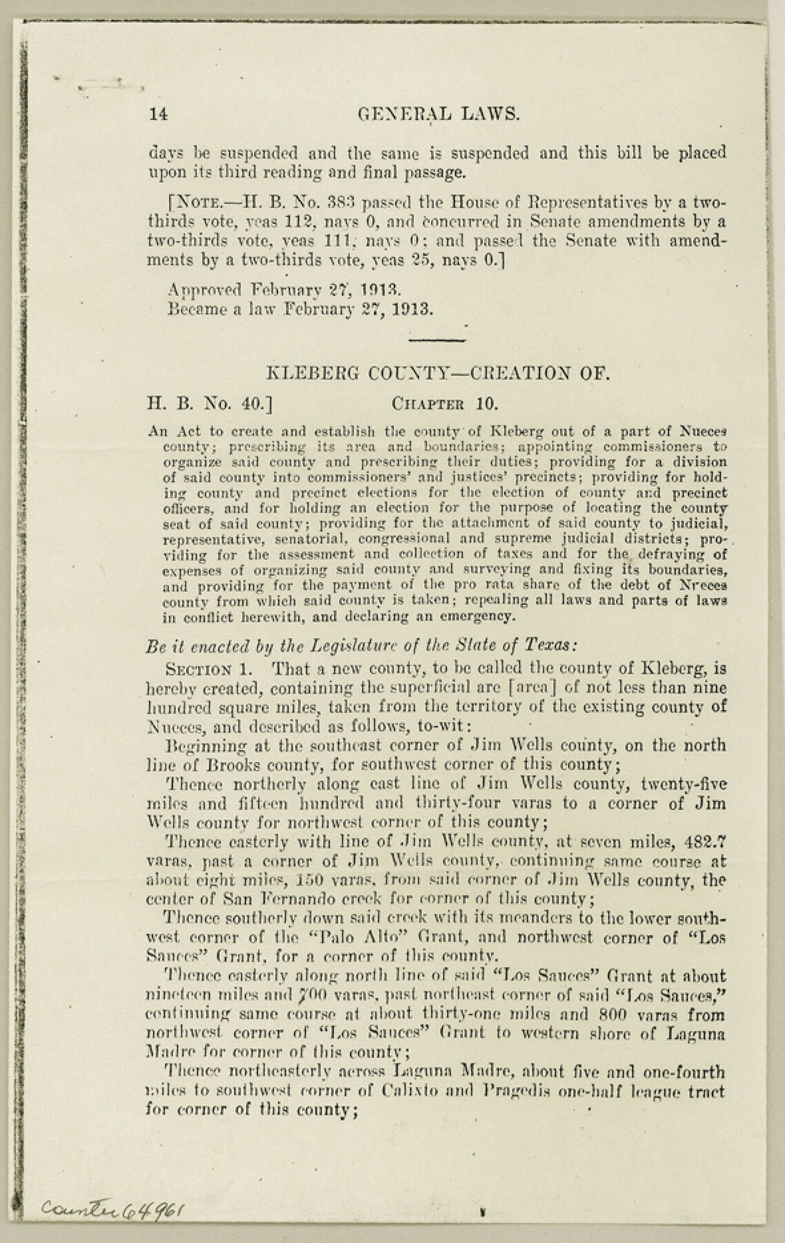
Kleberg County Boundary File 1
Creation of County
-
Map/Doc
64961
-
Collection
General Map Collection
-
Counties
Kleberg
-
Subjects
County Boundaries
-
Height x Width
9.3 x 5.9 inches
23.6 x 15.0 cm
Part of: General Map Collection
Trinity County Sketch File 5b

Print $4.00
- Digital $50.00
Trinity County Sketch File 5b
1855
Size 12.6 x 8.0 inches
Map/Doc 38506
Upton County Sketch File 27

Print $20.00
- Digital $50.00
Upton County Sketch File 27
1928
Size 42.9 x 22.6 inches
Map/Doc 10416

Controlled Mosaic by Jack Amman Photogrammetric Engineers, Inc - Sheet 9

Print $20.00
- Digital $50.00
Controlled Mosaic by Jack Amman Photogrammetric Engineers, Inc - Sheet 9
1954
Size 20.0 x 24.0 inches
Map/Doc 83453
Flight Mission No. CRC-3R, Frame 202, Chambers County

Print $20.00
- Digital $50.00
Flight Mission No. CRC-3R, Frame 202, Chambers County
1956
Size 18.7 x 22.4 inches
Map/Doc 84857
Nolan County Boundary File 1a

Print $22.00
- Digital $50.00
Nolan County Boundary File 1a
Size 8.9 x 8.2 inches
Map/Doc 57647
Flight Mission No. DCL-6C, Frame 95, Kenedy County

Print $20.00
- Digital $50.00
Flight Mission No. DCL-6C, Frame 95, Kenedy County
1943
Size 18.6 x 22.3 inches
Map/Doc 85925
Donley County Sketch File B10

Print $24.00
- Digital $50.00
Donley County Sketch File B10
1938
Size 14.3 x 9.1 inches
Map/Doc 21272
Flight Mission No. BQY-15M, Frame 10, Harris County

Print $20.00
- Digital $50.00
Flight Mission No. BQY-15M, Frame 10, Harris County
1953
Size 18.5 x 22.3 inches
Map/Doc 85308
Pecos County Working Sketch 26

Print $20.00
- Digital $50.00
Pecos County Working Sketch 26
1929
Size 27.6 x 28.6 inches
Map/Doc 71497
Hardeman County Sketch File 16

Print $20.00
- Digital $50.00
Hardeman County Sketch File 16
Size 21.9 x 26.8 inches
Map/Doc 11628
Burleson County Working Sketch 6

Print $20.00
- Digital $50.00
Burleson County Working Sketch 6
1980
Size 22.3 x 16.0 inches
Map/Doc 67725
You may also like
Childress County Rolled Sketch 1

Print $20.00
- Digital $50.00
Childress County Rolled Sketch 1
Size 31.2 x 26.5 inches
Map/Doc 5437
Liberty County Rolled Sketch Q

Print $20.00
- Digital $50.00
Liberty County Rolled Sketch Q
1890
Size 31.7 x 25.1 inches
Map/Doc 6625
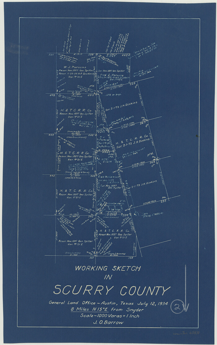
Scurry County Working Sketch 2
Print $3.00
- Digital $50.00
Scurry County Working Sketch 2
1934
Size 16.2 x 10.2 inches
Map/Doc 63831
Flight Mission No. DIX-5P, Frame 143, Aransas County

Print $20.00
- Digital $50.00
Flight Mission No. DIX-5P, Frame 143, Aransas County
1956
Size 17.0 x 17.1 inches
Map/Doc 83804

Duval County Working Sketch 55

Print $20.00
- Digital $50.00
Duval County Working Sketch 55
1936
Size 25.7 x 21.6 inches
Map/Doc 68779
Map No. 1 - Surveys Located in 1881 as they appear on the ground

Print $20.00
- Digital $50.00
Map No. 1 - Surveys Located in 1881 as they appear on the ground
Size 29.6 x 18.8 inches
Map/Doc 91889
Liberty County Boundary File 2

Print $9.00
- Digital $50.00
Liberty County Boundary File 2
Size 17.0 x 11.0 inches
Map/Doc 56293
"Capture of Cynthia Ann Parker"

Print $20.00
"Capture of Cynthia Ann Parker"
Size 20.0 x 16.0 inches
Map/Doc 94150
Rusk County Working Sketch 35

Print $20.00
- Digital $50.00
Rusk County Working Sketch 35
2005
Size 28.7 x 42.0 inches
Map/Doc 83584
Bexar County State Real Property Sketch 3

Print $20.00
- Digital $50.00
Bexar County State Real Property Sketch 3
2000
Size 18.8 x 22.5 inches
Map/Doc 61671
Flight Mission No. DQO-3K, Frame 38, Galveston County

Print $20.00
- Digital $50.00
Flight Mission No. DQO-3K, Frame 38, Galveston County
1952
Size 18.7 x 22.3 inches
Map/Doc 85079