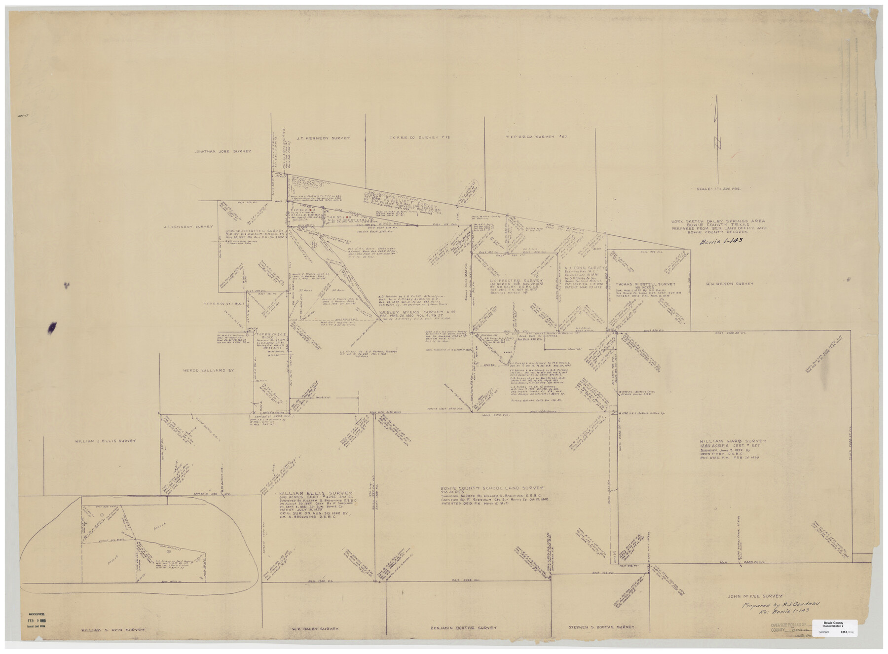
Bowie County Rolled Sketch 2
Work sketch Dalby Springs area Bowie County, Texas [re: Bowie 1-143]
-
Map/Doc
8454
-
Collection
General Map Collection
-
Object Dates
1965/2/9 (File Date)
-
People and Organizations
P.J. Goudeau (Surveyor/Engineer)
-
Counties
Bowie
-
Subjects
Surveying Rolled Sketch
-
Height x Width
37.8 x 51.3 inches
96.0 x 130.3 cm
-
Medium
blueprint/diazo
-
Scale
1" = 200 varas
Part of: General Map Collection
Brewster County Sketch File 40

Print $6.00
- Digital $50.00
Brewster County Sketch File 40
1910
Size 15.2 x 10.3 inches
Map/Doc 16302
Atascosa County Rolled Sketch 22

Print $40.00
- Digital $50.00
Atascosa County Rolled Sketch 22
1917
Size 25.9 x 57.4 inches
Map/Doc 8920
Portion of States Submerged Area in Matagorda Bay

Print $20.00
- Digital $50.00
Portion of States Submerged Area in Matagorda Bay
1923
Size 12.7 x 13.5 inches
Map/Doc 2956
Hood County Sketch File 16

Print $4.00
- Digital $50.00
Hood County Sketch File 16
1860
Size 10.2 x 8.2 inches
Map/Doc 26597
Flight Mission No. CLL-1N, Frame 189, Willacy County

Print $20.00
- Digital $50.00
Flight Mission No. CLL-1N, Frame 189, Willacy County
1954
Size 18.2 x 22.0 inches
Map/Doc 87059
[Surveys along Childress Creek in Bosque County]
![69759, [Surveys along Childress Creek in Bosque County], General Map Collection](https://historictexasmaps.com/wmedia_w700/maps/69759.tif.jpg)
Print $2.00
- Digital $50.00
[Surveys along Childress Creek in Bosque County]
1846
Size 11.6 x 8.5 inches
Map/Doc 69759
Galveston Bay Entrance

Print $20.00
- Digital $50.00
Galveston Bay Entrance
1953
Size 26.1 x 42.2 inches
Map/Doc 69860
Knox County Working Sketch 9

Print $20.00
- Digital $50.00
Knox County Working Sketch 9
1945
Size 33.8 x 43.3 inches
Map/Doc 70251
Colorado County Sketch File 16

Print $4.00
- Digital $50.00
Colorado County Sketch File 16
Size 8.2 x 10.3 inches
Map/Doc 18945
Atascosa County Sketch File 1a

Print $4.00
- Digital $50.00
Atascosa County Sketch File 1a
1858
Size 14.1 x 8.8 inches
Map/Doc 13722
Gregg County Working Sketch 16

Print $20.00
- Digital $50.00
Gregg County Working Sketch 16
1944
Size 14.8 x 27.9 inches
Map/Doc 63283
Stonewall County Sketch File 15

Print $40.00
- Digital $50.00
Stonewall County Sketch File 15
1905
Size 14.3 x 8.7 inches
Map/Doc 37255
You may also like
Tom Green County Sketch File 46 1/2

Print $40.00
- Digital $50.00
Tom Green County Sketch File 46 1/2
1882
Size 12.7 x 19.6 inches
Map/Doc 12440

Liberty County Rolled Sketch JP1

Print $40.00
- Digital $50.00
Liberty County Rolled Sketch JP1
1935
Size 41.9 x 60.8 inches
Map/Doc 9567
Donley County Boundary File 7

Print $31.00
- Digital $50.00
Donley County Boundary File 7
Size 11.3 x 8.6 inches
Map/Doc 52640
Zavala County Sketch File 23

Print $4.00
- Digital $50.00
Zavala County Sketch File 23
1885
Size 14.4 x 8.8 inches
Map/Doc 41380
Hall County Working Sketch 7

Print $20.00
- Digital $50.00
Hall County Working Sketch 7
1955
Size 31.6 x 18.2 inches
Map/Doc 63335
Carte du Spits-Berg, et partie de la Côte de Galles hams-kes au nouveau Groenland

Print $20.00
- Digital $50.00
Carte du Spits-Berg, et partie de la Côte de Galles hams-kes au nouveau Groenland
1782
Size 13.8 x 19.8 inches
Map/Doc 97123
Orange County Working Sketch 35

Print $20.00
- Digital $50.00
Orange County Working Sketch 35
1959
Size 28.8 x 25.0 inches
Map/Doc 71367
Map of Burnet Co.

Print $20.00
- Digital $50.00
Map of Burnet Co.
1887
Size 45.5 x 37.9 inches
Map/Doc 7816
The Republic County of Matagorda. Proposed, Late Fall 1837

Print $20.00
The Republic County of Matagorda. Proposed, Late Fall 1837
2020
Size 21.0 x 21.7 inches
Map/Doc 96214
Presidio County Sketch File 62

Print $10.00
- Digital $50.00
Presidio County Sketch File 62
1938
Size 11.2 x 8.8 inches
Map/Doc 34647
Colorado County Sketch File 35

Print $13.00
- Digital $50.00
Colorado County Sketch File 35
2005
Size 44.0 x 28.0 inches
Map/Doc 83564