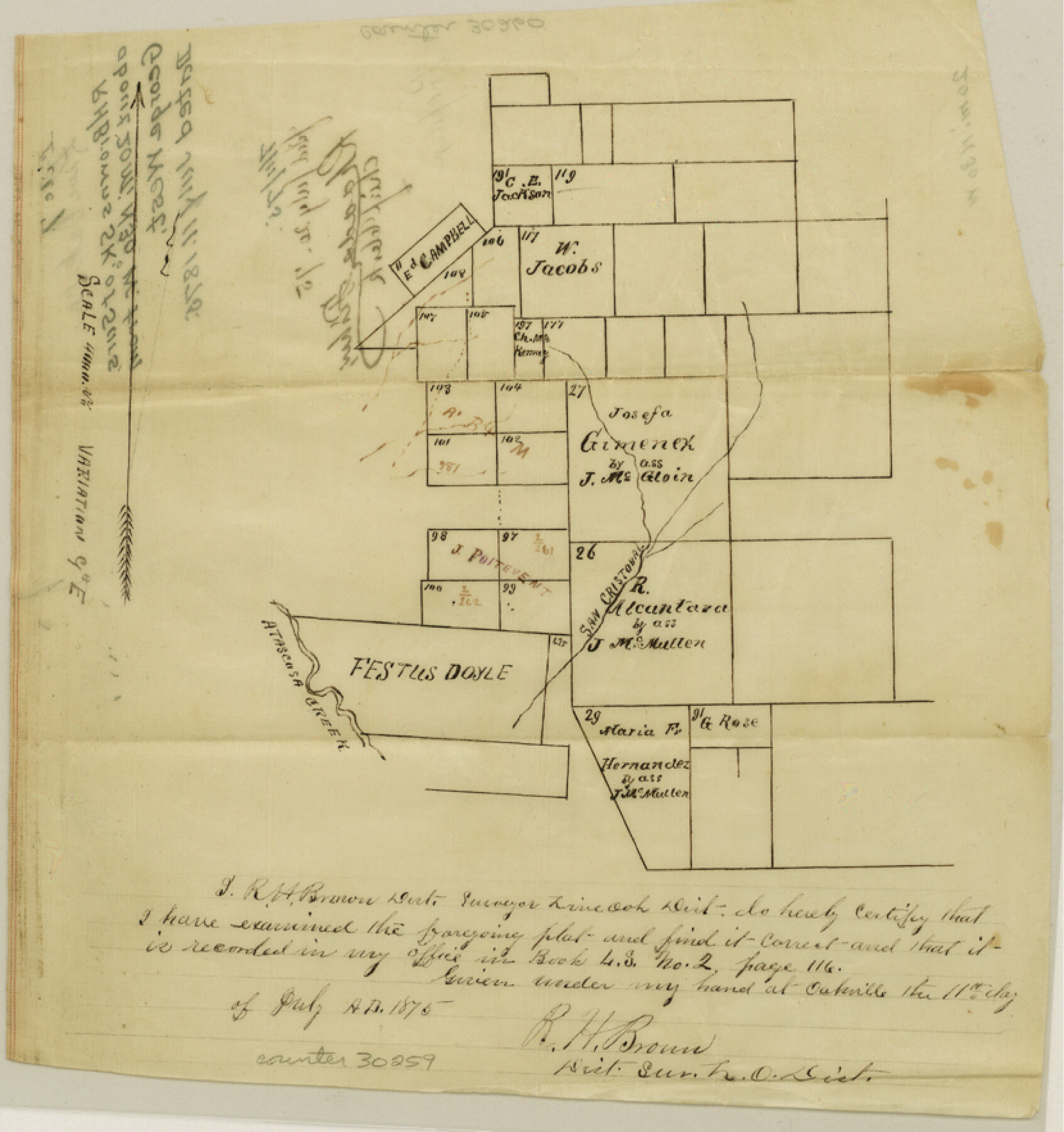
Live Oak County Sketch File 7
[Sketch of surveys northwest from George West]
-
Map/Doc
30259
-
Collection
General Map Collection
-
Object Dates
7/11/1875 (Creation Date)
7/20/1875 (File Date)
-
People and Organizations
R.H. Brown (Surveyor/Engineer)
-
Counties
Live Oak Atascosa
-
Subjects
Surveying Sketch File
-
Height x Width
8.8 x 8.3 inches
22.4 x 21.1 cm
-
Medium
paper, manuscript
-
Scale
1:4000
-
Features
Atascosa Creek
San Cristoval Creek
Part of: General Map Collection
[Surveys on the Trinity River]
![342, [Surveys on the Trinity River], General Map Collection](https://historictexasmaps.com/wmedia_w700/maps/342.tif.jpg)
Print $2.00
- Digital $50.00
[Surveys on the Trinity River]
Size 6.6 x 4.6 inches
Map/Doc 342
Rusk County Sketch File 27B

Print $20.00
Rusk County Sketch File 27B
1936
Size 15.4 x 19.9 inches
Map/Doc 12273
Comanche County Working Sketch 9

Print $20.00
- Digital $50.00
Comanche County Working Sketch 9
1954
Size 18.6 x 21.5 inches
Map/Doc 68143
Edwards County Working Sketch 70

Print $20.00
- Digital $50.00
Edwards County Working Sketch 70
1957
Size 22.5 x 22.4 inches
Map/Doc 68946
Hardin County Rolled Sketch 12

Print $20.00
- Digital $50.00
Hardin County Rolled Sketch 12
1949
Size 36.3 x 47.3 inches
Map/Doc 10200
Chambers County Sketch File 53

Print $12.00
- Digital $50.00
Chambers County Sketch File 53
1952
Size 14.3 x 8.9 inches
Map/Doc 18087
Travis County State Real Property Sketch 17

Print $20.00
- Digital $50.00
Travis County State Real Property Sketch 17
2012
Size 36.0 x 24.5 inches
Map/Doc 93354
Crosby County Sketch File 26

Print $28.00
- Digital $50.00
Crosby County Sketch File 26
1888
Size 14.1 x 8.6 inches
Map/Doc 20098

Henderson County Rolled Sketch 11

Print $20.00
- Digital $50.00
Henderson County Rolled Sketch 11
1915
Size 29.4 x 42.5 inches
Map/Doc 75946
Phelps & Ensign's Travellers' Guide, and Map of the United States containing the roads, distances, steam boat and canal routes & c.

Print $20.00
- Digital $50.00
Phelps & Ensign's Travellers' Guide, and Map of the United States containing the roads, distances, steam boat and canal routes & c.
1841
Size 28.8 x 33.9 inches
Map/Doc 96875
Val Verde County Rolled Sketch 77

Print $20.00
- Digital $50.00
Val Verde County Rolled Sketch 77
1981
Size 36.2 x 37.4 inches
Map/Doc 10087
You may also like
Pecos County Working Sketch 61

Print $20.00
- Digital $50.00
Pecos County Working Sketch 61
1952
Size 28.4 x 22.7 inches
Map/Doc 71533
Reeves County Rolled Sketch 24

Print $20.00
- Digital $50.00
Reeves County Rolled Sketch 24
1982
Size 37.2 x 24.9 inches
Map/Doc 7493
Outer Continental Shelf Leasing Maps (Louisiana Offshore Operations)

Print $20.00
- Digital $50.00
Outer Continental Shelf Leasing Maps (Louisiana Offshore Operations)
1959
Size 17.8 x 14.1 inches
Map/Doc 76095
Coast Chart No. 210 Aransas Pass and Corpus Christi Bay with the coast to latitude 27° 12' Texas

Print $20.00
- Digital $50.00
Coast Chart No. 210 Aransas Pass and Corpus Christi Bay with the coast to latitude 27° 12' Texas
1913
Size 27.6 x 18.2 inches
Map/Doc 72807
Tarrant County Boundary File 4 and 4a

Print $6.00
- Digital $50.00
Tarrant County Boundary File 4 and 4a
Size 11.5 x 9.0 inches
Map/Doc 59151
Harris County Sketch File 12

Print $40.00
- Digital $50.00
Harris County Sketch File 12
1896
Size 16.1 x 12.5 inches
Map/Doc 25353
Red River County Sketch File 14

Print $8.00
- Digital $50.00
Red River County Sketch File 14
Size 13.7 x 9.0 inches
Map/Doc 35133
Matagorda County Sketch File 4

Print $4.00
- Digital $50.00
Matagorda County Sketch File 4
1876
Size 7.9 x 12.8 inches
Map/Doc 30734
Dawson County Sketch File 26

Print $10.00
- Digital $50.00
Dawson County Sketch File 26
Size 14.7 x 9.1 inches
Map/Doc 20583
Starr County Rolled Sketch 44

Print $20.00
- Digital $50.00
Starr County Rolled Sketch 44
Size 38.0 x 46.0 inches
Map/Doc 9943
Old Miscellaneous File 38

Print $40.00
- Digital $50.00
Old Miscellaneous File 38
1841
Size 57.8 x 33.9 inches
Map/Doc 75282
Colorado River Project - Texas, Marshall Ford Dam right of way survey

Print $20.00
- Digital $50.00
Colorado River Project - Texas, Marshall Ford Dam right of way survey
1937
Size 22.1 x 42.0 inches
Map/Doc 3151